Related Research Articles

The Brahmaputra is a trans-boundary river which flows through Tibet (China), Northeastern India, and Bangladesh. It is known as Brahmaputra or Luit in Assamese, Yarlung Tsangpo in Tibetan, the Siang/Dihang River in Arunachali, and Jamuna River in Bengali. It is the 9th largest river in the world by discharge, and the 15th longest.

Golaghat district (Pron:ˌgəʊləˈgɑ:t) is an administrative district in the state of Assam in India. It attained district status in 1987. The district headquarters are located at Golaghat. The district occupies an area of3,502 km2 (1,352 sq mi) and lies 100 metres (330 ft) above sea level.

Morigaon district is an administrative district in the state of Assam in India. The district headquarters is located at Morigaon. The ancient place of occult Mayong is located in this district as well as Pobitora Wildlife Sanctuary.

Nagaon district is an administrative district in the Indian state of Assam. At the time of the 2011 census it was the most populous district in Assam, before Hojai district was split from it in 2016.

Dimapur is the largest city and municipality in the Indian state of Nagaland. As of 2011, the municipality had a population of 122,834. The city is the main gateway and commercial centre of Nagaland. Located near the border with Assam along the banks of the Dhansiri River. Its main railway station is the second busiest station in Northeast India. The District of Dimapur is bifurcated into two other districts; namely, Chumoukedima and Niuland.

The Dooars or Duars are the alluvial floodplains in eastern-northeastern India and southern Bhutan that lie south of the outer foothills of the Himalayas and north of the Brahmaputra River basin. This region is about 30 km (19 mi) wide and stretches over about 350 km (220 mi) from the Teesta River in West Bengal to the Dhansiri River in Udalguri district of Assam. The region forms the gateway to Bhutan. It is part of the Terai-Duar savanna and grasslands ecoregion.

Nagaon is a city and a municipal board in Nagaon district in the Indian state of Assam. It is situated 122.6 kilometres (76 mi) east of Guwahati.

The Dimasa Kingdom was a late medieval/early modern kingdom in Assam, Northeast India ruled by Dimasa kings. The Dimasa kingdom and others that developed in the wake of the Kamarupa kingdom were examples of new states that emerged from indigenous communities in medieval Assam as a result of socio-political transformations in these communities. The British finally annexed the kingdom: the plains in 1832 and the hills in 1834. This kingdom gave its name to undivided Cachar district of colonial Assam. And after independence the undivided Cachar district was split into three districts in Assam: Dima Hasao district, Cachar district, Hailakandi district. The Ahom Buranjis called this kingdom Timisa.
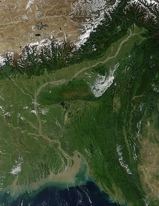
The Brahmaputra Valley is a region situated between hill ranges of the eastern and northeastern Himalayan range in Eastern India.

Dihing or Burhi Dihing is a large tributary, about 380 kilometres (240 mi) long, of the Brahmaputra River in Upper Assam in northeastern India. The river originates at 2,375 metres (7,792 ft) above sea level in the Eastern Himalayas in Arunachal Pradesh and flows through Tinsukia and Dibrugarh Districts in Assam to its confluence with the Brahmaputra at Dihingmukh. Its watershed covers about 6,000 square kilometres (2,300 sq mi). The Dihing has created number of oxbow lakes in the area.

The Dhansiri is a river of Golaghat District of Assam and the Chümoukedima District and Dimapur District of Nagaland. It originates from Laisang peak of Nagaland. It flows through a distance of 352 kilometres (219 mi) from south to north before joining the Brahmaputra on its south bank. Its total catchment area is 1,220 square kilometres (470 sq mi).

Kaziranga National Park is an Indian national park and a World Heritage Site in Golaghat and Nagaon districts of Assam, India. It is refuge for the world's largest population of Great One-horned Rhinoceros. The park has many elephant, water buffalo and swamp deer. It is recognized as an Important Bird Area by BirdLife International for conservation of avifaunal species. The park has achieved notable progress in wildlife conservation despite several constraints.
Bhairabkunda is a popular picnic spot in Udalguri district in the State of Assam, India. It is situated on the border of Bhutan.
Old NH-37 is now National Highway 127. It's a national highway of India. It connects Nagaon, New Gatanga and Jakhalabandha in the state of Assam.
The Kolong River or Kailang is an anabranch of the Brahmaputra River, which diverts out from the Brahamputra river in Hatimura region of Jakhalabandha, and meets the same at Kolongpar near Guwahati. The tributary is about 250 kilometres (160 mi) long and flows through the districts of Nagaon, Morigaon and Kamrup. On the way, several smaller streams meet it. The river flows through the heart of the Nagaon urban area, dividing the town into Nagaon and Haiborgaon.
Assam – 16th largest, 15th most populous and 26th most literate state of the 28 states of the democratic Republic of India. Assam is at 14th position in life expectancy and 8th in female-to-male sex ratio. Assam is the 21st most media exposed states in India. The Economy of Assam is largely agriculture based with 69% of the population engaged in it. Growth rate of Assam's income has not kept pace with that of India's during the Post-British Era; differences increased rapidly since the 1970s. While the Indian economy grew at 6 percent per annum over the period of 1981 to 2000, the same of Assam's grew only by 3.3 percent.
The Diju River is a sub- tributary of the Brahmaputra River in the Indian state of Assam.

Samaguri Beel is an ox-bow shaped (U-shaped) wetland and lake located near to Nagaon town in Nagaon district of Assam. The Beel is situated in the Brahmaputra River basin. The lake was formed by the abandoned path of the Kolong River.
The Chathe is a river that flows through the Chümoukedima District of Nagaland, it flows to join the Dhansiri River in Assam which together in turn is a left tributary of the Brahmaputra River.
The Doyang is the longest and largest river in the Indian state of Nagaland. With its origin from small streams near the Nagaland–Manipur border, it first flows to the form the River Dzüü and Sidzü which flows in a parallel direction in Kohima District and Phek District to meet at the Zünheboto District. It then flows to Wokha District where it is known by its name, the Doyang and moves south west direction and then north in Assam to join the Dhansiri which together in turn is a left tributary of the Brahmaputra.
References
- 1 2 3 4 5 6 7 8 9 10 11 12 13 14 15 16 17 18 19 20 21 "Brahmaputra". Water Resources Information System of India. Retrieved 5 September 2013.
- 1 2 3 4 5 6 7 8 9 10 11 12 13 14 15 16 17 18 19 20 21 22 23 24 25 26 27 28 Borah, Pranjal. "Principal Rivers in Assam". Assam Online Portal.
- ↑ "Action plan for Kolong river-priority V" (PDF). Pollution Control Board Assam. Retrieved 3 November 2020.