
Lake Nokomis is one of several lakes in Minneapolis, Minnesota, United States. The lake was previously named Lake Amelia in honor of Captain George Gooding's daughter, Amelia, in 1819. Its current name was adopted in 1910 to honor Nokomis, grandmother of Hiawatha. It is located in the southern part of the city, west of the Mississippi River and south of Lake Hiawatha. The lake is oval in shape, with a long axis running southwest to northeast. Two pathways circle the lake, a 2.7-mile (4.3 km) pedestrian tail and a 2.8-mile (4.5 km) bicycle trail. Because the lower part of the lake is crossed by Cedar Avenue running north–south, the impression from the ground is that the lake is shaped like an L. The lake has an area of 204 acres (0.83 km2).

The Grand Rounds National Scenic Byway is a linked series of park areas in Minneapolis, Minnesota, United States, that takes a roughly circular path through the city. The Minneapolis Park and Recreation Board developed the system over many years. The corridors include roads for automobile traffic plus separate paths for pedestrians and bicycles, and extend slightly into neighboring cities. About 50 miles (80 km) of roadway and paths are in the system, and much of it was built in the 1930s as part of Civilian Conservation Corps projects.

Lake Harriet is a lake in the southwest part of Minneapolis, just south of Bde Maka Ska and north of Minnehaha Creek. The lake is surrounded by parkland as part of the Minneapolis Chain of Lakes. The lake has an area of 335 acres (1.36 km2) and a maximum depth of 85 feet (26 m).

Cedar Lake is a lake in Minneapolis, Minnesota, United States, and part of the city's Chain of Lakes. It is located on the west side of the city, north of Bde Maka Ska and west of Lake of the Isles. The lake is surrounded by parkland on the west side, while the east side borders the Kenwood residential area. The north side is bordered by the Cedar Lake Trail and the BNSF Railway. Cedar Lake has an area of 169 acres (0.68 km2) and a maximum depth of 51 feet (16 m). Minneapolis Park and Recreation Board manages parkland around the lake.

Lake Hiawatha is located just north of Lake Nokomis in Minneapolis, Minnesota. It was purchased by the Minneapolis Park and Recreation Board in 1922 for $550,000. At that time the lake was a marsh known as Rice Lake, but over four years, the park system transformed the wetland into a lake surrounded by a park.

Lake Street is a major east-west thoroughfare in Minneapolis, Minnesota which is located between 29th and 31st Streets in south Minneapolis. It was named such because it runs through the Chain of Lakes area on the west side of town and passes over a small channel linking Bde Maka Ska and Lake of the Isles.

Cedar Lake Trail is a 4.3-mile (6.9 km), shared-use path in the U.S. state of Minnesota, from downtown Minneapolis to the neighboring suburb of St. Louis Park. The trail begins at its eastern trailhead in downtown Minneapolis (44°59′11″N93°16′01″W) and continues west to Minnesota State Highway 100 in St. Louis Park (44°57′43″N93°20′36″W). At the trail's west end, a paved path continues for another 4.2 miles (6.8 km) through St. Louis Park to Hopkins under the former name of Hutchinson Spur Trail, but known as North Cedar Lake Regional Trail since 2009. In 2019, large portions of the Cedar Lake Trail were closed due to construction of the Southwest LRT extension with expected reopening in 2021 or 2022.

The Midtown Greenway is a 5.7-mile (9.2 km) rail trail in Minneapolis, Minnesota. It is considered under segregated cycle facilities.

Three Rivers Park District is a special park district serving the suburban areas of the Twin Cities including suburban Hennepin, Carver, Dakota, Scott and Ramsey counties. Three Rivers's mission is "To promote environmental stewardship through recreation and education in a natural resources-based park system." Three Rivers operates twenty parks and ten regional trails, with at least two more regional trails planned. Nearly seven million people visit Three Rivers facilities each year. It has over 27,000 acres (11,000 ha) of parks and trails.

Longfellow is a defined community in Minneapolis, Minnesota which includes five smaller neighborhoods inside of it: Seward, Cooper, Hiawatha, Howe and Longfellow. Grouped with South Minneapolis between the city's eastern border with the Mississippi River and the Metro Blue Line, Longfellow takes its name from Longfellow neighborhood which in turn is named after Henry Wadsworth Longfellow. The renowned American poet incorporated elements into his poem The Song of Hiawatha from Henry Schoolcraft's accounts of native Dakota lore in Minnesota which included Minnehaha Falls in Longfellow's southern tip. The early reference of Highway 55 as Hiawatha Avenue, along the west border, may have influenced the naming decision when community borders were drawn in the 1960s. Hiawatha Avenue is the main thoroughfare leading north into Downtown Minneapolis and south to the Minneapolis-Saint Paul Airport.

Southwest LRT Trail is a system of shared-use paths for bicycles and pedestrian paths that extends through several western suburbs of Minneapolis, Minnesota. They are operated by the Three Rivers Park District. Two former rail corridors originally built by the Minneapolis and St. Louis Railway were acquired and converted to trails in anticipation of the Southwest Corridor light rail project. The two former railway corridors are now divided into three distinct trails.
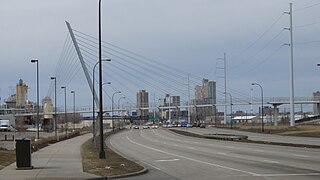
The Martin Olav Sabo Bridge is a bridge in the city of Minneapolis and the first cable-stayed suspension bridge in the U.S. state of Minnesota. Formerly the Midtown Greenway Pedestrian Bridge, it was renamed in honor of former Representative Martin Olav Sabo, a fourteen-term member of Congress from Minnesota.

The Kenilworth Trail is a paved bicycle trail in Minneapolis, Minnesota, United States. It runs nearly 1.5 miles (2.4 km) and acts as a connector between the Cedar Lake Trail in the north and the Midtown Greenway in the south. Like the Cedar Lake Trail, most of the route is composed of a triple-divided cycleway/pedway with a pair of one-way paths for bicycles and another path for pedestrians. On some maps, a southern segment of the Kenilworth Trail is called the Burnham Trail. The trail corridor has been considered the most highly trafficked in the Minneapolis park system.
The Minneapolis Park and Recreation Board (MPRB) is an independent park district that owns, maintains, and programs activities in public parks in Minneapolis, Minnesota, United States. It has 500 full-time and 1,300 part-time employees and an $111 million operating and capital budget.

Winchell Trail is a five-mile (8 km) round trip, pedestrian-only trail in Minneapolis, Minnesota, United States, that runs along the west side of the Mississippi River between Franklin Avenue South and East 44th Street. Popular with bird watchers and naturalists, the rustic trail provides Upper Mississippi River gorge access and views. The trail is separate from the adjacent multi-use bicycle path, taking hikers past sandy beaches, an oak savanna restoration project, and the floodplain forest. The trail has multiple access points and the section from East 38th Street to East 44th Street is paved. Described as moderate and for all hiking skill levels, the out-and-back Winchell Trail has total elevation gain of 501 feet (153 m). Portions of the trail can be hiked in near solitude as its age and general destitute make it a widely forgotten place to explore.

Minnehaha Trail is a 1.5-mile (2.4 km) paved, multi-use trail in Minneapolis, Minnesota, United States, that connects Minnehaha Regional Park and Fort Snelling State Park – two of the most popular recreation destinations in the Twin Cities metro area. The trail is considered a segment of a longer, loosely connected bicycle route system along the Mississippi River. Users of Minnehaha Trail traverse under a lush forest canopy and may occasionally spot wildlife. The trail received local recognition for its natural beauty, but it was criticized for its worn pavement and lack of signage.

Hiawatha LRT Trail is a 4.7-mile (7.6 km), multi-use path adjacent to a light-rail transit line in Minneapolis, Minnesota, United States, that is popular with bicycle commuters. Users travel along the Metro Blue Line and Hiawatha Avenue transit corridor, reaching downtown Minneapolis near an indoor sports stadium at the trail’s northern end, and reaching a bridge above Minnehaha Creek at the trail’s southern end. Hiawatha LRT Trail provides a vital link between several Minneapolis neighborhoods and the city’s downtown area.

Little Earth Trail is an approximately 1-mile (1.6 km), multi-use bicycle path in Minneapolis, Minnesota, United States, that links several neighborhoods, parks, businesses, and trails in the Phillips community. The trail begins at its northern end near the intersection of East Franklin Avenue and 16th Avenue South and eventually follows the west side of Hiawatha Avenue to the Midtown Greenway and Martin Olav Sabo Bridge. Named after the nearby Little Earth community, the shared-use pathway provides transportation and recreation opportunities, and is a frequent location of activism on social justice issues in Minneapolis.

Min Hi Line is a proposed linear park and shared-use path that would eventually re-purpose an active rail and agri-industrial corridor in the Longfellow community of Minneapolis, Minnesota, United States. Modeled after successful projects like the Atlanta Beltline and New York High Line, it would feature an approximately 3-mile (4.8 km), shared-use pathway that traverses housing, retail, commercial buildings, gardens, playgrounds, and public art installments. Two pilot projects completed in 2018 and 2019 connect the Min Hi Line corridor to trail systems at its northern and southern ends.
