Listed buildings in Knutsford

Last updated

King Street, showing the Gaskell Memorial Tower King Street, Knutsford - geograph.org.uk - 1225548.jpg
King Street, showing the Gaskell Memorial Tower

Knutsford is a market town in Cheshire East, England. Historically, its two main streets are Princess Street and King Street, which still contain 17th and 18th-century houses and shops, and Georgian buildings. [1] The prosperity of the town grew with the arrival of the railway, and this resulted in the building of large houses to the south of the town, including the eccentric villas designed by Richard Harding Watt. [2]

Contents

This list contains all the structures included in the National Heritage List for England in Knutsford. There is one listed at Grade I, the 17th-century Brook Street Chapel, which is the burial place of the novelist Mrs Gaskell. Two Anglican churches, St John the Baptist, dating from the 18th century and Neoclassical in style, and the 19th-century Gothic Revival Church of St Cross, are listed at Grade II*, together with five other buildings. The rest of the listed buildings are in Grade II.

Key

Map all coordinates using: OpenStreetMap  
Download coordinates as: KML
GradeCriteria [3]
Grade IBuildings of exceptional interest, sometimes considered to be internationally important.
Grade II*Particularly important buildings of more than special interest.
Grade IIBuildings of national importance and special interest.

Listed buildings

Name and locationPhotographDateNotesGrade
48 King Street
53°18′14″N2°22′22″W / 53.3038°N 2.3727°W / 53.3038; -2.3727 (48 King Street)
16th century (or earlier)Originally a timber-framed house, later in commercial use, it was refronted in 1907. It has two storeys and a slate roof. [4] II
84 and 86 King Street
53°18′18″N2°22′26″W / 53.3051°N 2.3740°W / 53.3051; -2.3740 (84 and 86 Street)
16th century (probable)A timber-framed house with a slate roof, its exterior partly painted. It incorporates some close studding. Alterations and extensions were made to it in the 19th and 20th centuries. It is in the form of an H-plan. [5] II
88 King Street
53°18′19″N2°22′26″W / 53.3052°N 2.3740°W / 53.3052; -2.3740 (88 King Street)
16th century (probable)A timber-framed house with a slate roof, later a shop. The upper storey is jettied. [6] II
White Bear Public House
53°18′17″N2°22′35″W / 53.3047°N 2.3763°W / 53.3047; -2.3763 (White Bear Public House)
The White Bear, Knutsford - geograph.org.uk - 239525.jpg
Late 16th century (probable)The building was refurbished in the early 20th century. It is timber-framed, encased in rendered mock timberwork, and has a thatched roof. [7] II
57, 59, and 61 King Street
53°18′14″N2°22′21″W / 53.3039°N 2.3725°W / 53.3039; -2.3725 (57, 59, and 61 King Street)
Late 16th century or early 17th century
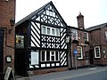
Originally three houses, later three shops. Timber-framed with rendering at the front, the roofs are in slate. Inside is decorative plasterwork dating from about 1630. [8] [9] II
38, 40 and 42 King Street
53°18′12″N2°22′18″W / 53.3032°N 2.3718°W / 53.3032; -2.3718 (38, 40 and 42 King Street)
Early 17th centuryA row of three timber-framed cottages, later altered, especially in about 1920. It has a shingle roof with five dormer windows. [10] II
43 and 45 King Street
53°18′13″N2°22′20″W / 53.3037°N 2.3722°W / 53.3037; -2.3722 (43 and 45 King Street)
Early 17th centuryA timber-framed house with brick infill and a slate roof. [11] II
Outbuildings, Old Court House, Chelford Road
53°17′48″N2°21′43″W / 53.2968°N 2.3619°W / 53.2968; -2.3619 (Outbuildings, Old Court House)
Early 17th centuryProbably originated as stables; timber-framed with brick infill. [12] II
29 Chelford Road
53°17′51″N2°21′38″W / 53.2974°N 2.3606°W / 53.2974; -2.3606 (29 Chelford Road)
Early 17th century (probable)A timber-framed cottage with a thatched roof; it probably originally had a single-room plan. [13] II
Old Court House and West Court, Chelford Road
53°17′50″N2°21′42″W / 53.2971°N 2.3618°W / 53.2971; -2.3618 (Old Court House and West Court)
Early 17th century (probable)Initially a single house, later divided into two houses. The original part, now rendered, was probably timber-framed, and the later part is in brick. [14] II
White Lion, 94 King Street
53°18′20″N2°22′27″W / 53.3055°N 2.3742°W / 53.3055; -2.3742 (White Lion)
The White Lion, Knutsford - geograph.org.uk - 550929.jpg
17th century Timber-framed with some rebuilding and refronting in brick. It is in the form of an H-plan and has a slate roof. [15] [16] II
131 King Street
53°18′24″N2°22′26″W / 53.3067°N 2.3739°W / 53.3067; -2.3739 (131 King Street)
131, King Street, Knutsford.jpg
Late 17th centuryOriginally a house, later converted into offices. It is in two storeys, constructed in painted brick, and has a slate roof. Its façade is in Artisan Mannerist style. [17] II
95 King Street
53°18′18″N2°22′25″W / 53.3049°N 2.3736°W / 53.3049; -2.3736 (95 King Street)
Late 17th century (possible)A three-storey painted brick house with a slate roof, later in commercial use, and much altered. [18] II
Brook Street Chapel
53°18′06″N2°22′12″W / 53.3017°N 2.3701°W / 53.3017; -2.3701 (Brook Street Chapel)
Knutsford Brook 1.jpg
1689This is a brick building with a stone-slate roof, expressed externally in two storeys, but interiorly is a single cell. The chapel was attended by Mrs Gaskell, who is buried in the churchyard. It is in use as a Unitarian chapel. [19] [20] I
93 King Street
53°18′17″N2°22′24″W / 53.3048°N 2.3734°W / 53.3048; -2.3734 (93 King Street)
1697A timber-framed house encased in brick, later in commercial use. It has two storeys and an attic. [15] [21] II
68, 70 and 70A King Street
53°18′16″N2°22′24″W / 53.3045°N 2.3734°W / 53.3045; -2.3734 (68, 70 and 70A King Street)
1701Originally a terrace of two or three houses, later two shops. Built in brick with a slate roof in three storeys. [22] II
50 King Street
53°18′14″N2°22′22″W / 53.3039°N 2.3727°W / 53.3039; -2.3727 (50 King Street)
1721A 2½-storey house in brick with a slate roof, later converted for commercial use. [23] II
1 and 2 Church Hill
53°18′13″N2°22′22″W / 53.3035°N 2.3729°W / 53.3035; -2.3729 (1 and 2 Church Hill)
1 and 2, Church Hill, Knutsford 02.jpg
Early 18th centuryA three-storey painted brick house with a slate roof, later divided into two dwellings and used as offices. The principal entrance is in the centre and has a Gibbs surround. The windows are sashes with twelve panes. [24] II
125 King Street
53°18′22″N2°22′26″W / 53.3061°N 2.3740°W / 53.3061; -2.3740 (125 King Street)
Early 18th centuryA house, possibly originally an inn, part of which has since been used as offices. It is constructed in brick with stone dressings, and has a slate roof. An arched entry leads to the rear yard. [25] II*
St John the Baptist's Church
53°18′11″N2°22′22″W / 53.3031°N 2.3729°W / 53.3031; -2.3729 (St John the Baptist's Church)
Knutsford swJanaChrzciciela.jpg
1741–44The church was designed in neoclassical style by J. Garlive. It is constructed in brick with stone dressings, and has a slate roof. In 1879 the chancel was extended and reordered by Alfred Darbyshire. [26] [27] II*
3 and 5 Brook Lane
53°18′03″N2°22′08″W / 53.3007°N 2.3689°W / 53.3007; -2.3689 (3 and 5 Brook Lane)
1742Originally a single house, now divided into two dwellings. It has two storeys, is built in brick, and has a slate roof. [28] II
16 Gaskell Avenue
53°18′14″N2°22′42″W / 53.3038°N 2.3783°W / 53.3038; -2.3783 (16 Gaskell Avenue)
Mid-18th centuryA brick house with a slate roof in two and three storeys, with later additions. [29] II
Heathwaite,
17 Gaskell Avenue
53°18′14″N2°22′43″W / 53.3038°N 2.3785°W / 53.3038; -2.3785 (Heathwaite, 17 Gaskell Avenue)
Elizabeth Gaskells House - geograph.org.uk - 80814.jpg
Mid-18th centuryA brick house with a slate roof in two and three storeys, with later additions. The childhood home of Mrs Gaskell. The gate and railings to the front garden dating from the 19th century are also listed. [30] [31] II
Heath House,
19 and 20 Gaskell Avenue
53°18′14″N2°22′43″W / 53.3038°N 2.3785°W / 53.3038; -2.3785 (Heath House, Gaskell Avenue)
Mid-18th centuryA house in roughcast brick with a slate roof in three storeys forming two dwellings. [32] II
Hollingford House,
1 Toft Road
53°18′09″N2°22′25″W / 53.3025°N 2.3735°W / 53.3025; -2.3735 (Hollingford House)
Mid-18th centuryBuilt as a house, later converted into a shop. [33] II
Lord Eldon Public House,
Tatton Street
53°18′20″N2°22′31″W / 53.3055°N 2.3753°W / 53.3055; -2.3753 (Lord Eldon Public House)
Knutsford, Lord Eldon - geograph.org.uk - 1314773.jpg
Mid-18th centuryOriginally a house with a baffle entry, it is constructed in brick, and has a slate roof and three-light casement windows throughout. Later converted into a public house. [34] II
Obelisk,
Chelford Road
53°17′42″N2°21′25″W / 53.2949°N 2.3570°W / 53.2949; -2.3570 (Obelisk)
Mid-18th centuryA square pillar in rusticated stone, thought to be a memorial to the Legh family. [35] II
Beson Hill Cottage and Rose Cottage, Tabley Road
53°18′37″N2°23′33″W / 53.3103°N 2.3924°W / 53.3103; -2.3924 (Beson Hill Cottage and Rose Cottage)
Mid-18th century (probable)A pair of cottages in two storeys, constructed in brick with thatched roofs. [36] II
98 King Street
53°18′22″N2°22′27″W / 53.3060°N 2.3743°W / 53.3060; -2.3743 (98 King Street)
c. 1750Originally a house, later converted into offices. It is in red brick with a slate roof, and has three storeys. [37] II*
Freemasons Arms Public House
53°18′15″N2°22′28″W / 53.3041°N 2.3745°W / 53.3041; -2.3745 (Freemasons Arms)
1754This was built as a silk mill, converted into three dwellings in 1818, and then into a public house in the 1890s. The three-storey building is constructed in brick with a slate roof. [38] II
113 King Street
53°18′20″N2°22′26″W / 53.3056°N 2.3739°W / 53.3056; -2.3739 (113 King Street)
1763Originally a three-storey house, later converted into offices. Built in brick with a slate roof. [39] II
15 King Street
53°18′10″N2°22′16″W / 53.3028°N 2.3712°W / 53.3028; -2.3712 (15 King Street)
Late 18th centuryA painted brick house with a slate roof in two storeys. [40] II
17 and 19 King Street
53°18′10″N2°22′17″W / 53.3029°N 2.3713°W / 53.3029; -2.3713 (17 and 19 King Street)
Late 18th centuryA pair of three-storey brick houses with slate roofs, later converted into two shops with offices above. [41] II
31 and 33 King Street
53°18′12″N2°22′18″W / 53.3032°N 2.3717°W / 53.3032; -2.3717 (31 and 33 King Street)
Late 18th centuryA brick house with a slate and stone-flagged roof in three storeys, later converted into two shops with offices above. [42] II
108–116 King Street
53°18′24″N2°22′27″W / 53.3067°N 2.3743°W / 53.3067; -2.3743 (108–116 King Street)
108-116, King Street, Knutsford.jpg
Late 18th centuryA terrace of five cottages in painted brick with a tiled roof. [43] II
115, 117, 117A and 117B King Street
53°18′21″N2°22′26″W / 53.3058°N 2.3740°W / 53.3058; -2.3740 (115, 117, 117A and 117B King Street)
Late 18th centuryA terrace of four houses, later converted into shops and offices. In brick with stone dressings and a slate roof, it has three storeys and an attic. [44] II
1 and 3 Princess Street
53°18′12″N2°22′27″W / 53.3034°N 2.3743°W / 53.3034; -2.3743 (1 and 3 Princess Street)
Late 18th centuryOriginally a house. later converted into a pair of shops. Constructed in brick with a slate roof, it is in three storeys. [45] II
10A Princess Street
53°18′14″N2°22′30″W / 53.3038°N 2.3751°W / 53.3038; -2.3751 (10A Princess Street)
10A, Princess Street, Knutsford.jpg
Late 18th centuryOriginally a house, later a shop. In two storeys, it is constructed in brick with a slate roof. [46] II
Angel Hotel, 96 King Street
53°18′21″N2°22′27″W / 53.3057°N 2.3742°W / 53.3057; -2.3742 (Angel Hotel)
Late 18th centuryOriginally a coaching inn, later a public house. Built in brick with stone dressings and a slate roof, it is in three storeys. [15] [47] II
Royal George Hotel,
King Street
53°18′18″N2°22′26″W / 53.3051°N 2.3740°W / 53.3051; -2.3740 (Royal George Hotel)
Late 18th centuryBuilt as a coaching inn, later a hotel. It is in brick with a slate roof, and has a plan of three parallel ranges. [15] [48] II
Park House,
129 King Street
53°18′24″N2°22′26″W / 53.3066°N 2.3740°W / 53.3066; -2.3740 (Park House)
Late 18th centuryA three-storey house, later converted into offices, constructed in brick with a slate roof. [49] II
Paradise Green Cottages
Toft Road
53°17′52″N2°22′15″W / 53.2977°N 2.3709°W / 53.2977; -2.3709 (Paradise Green Cottages)
Late 18th centuryA row of three two-storey cottages built in brick with slate roofs with small gabled timber porches. [50] II
Sundial
53°18′10″N2°22′25″W / 53.3029°N 2.3737°W / 53.3029; -2.3737 (Sundial, St John's Churchyard)
Sundial in Knutsford churchyard.jpg
Late 18th century (probable)In the churchyard of St John's is a stone baluster sundial on a plinth. The disc is missing. [19] [51] II
21 and 23 King Street
53°18′11″N2°22′17″W / 53.3031°N 2.3714°W / 53.3031; -2.3714 (21 and 23 King Street)
Late 18th century or early 19th centuryA pair of brick houses with slate roofs in three storeys. [52] II
76, 78 and 80 King Street
53°18′18″N2°22′26″W / 53.3049°N 2.3738°W / 53.3049; -2.3738 (76, 78 and 80 King Street)
1785A terrace of three houses, later converted for use as shops. In three storeys, and built in brick with a slate roof. [53] II
119, 121 and 123 King Street
53°18′21″N2°22′26″W / 53.3059°N 2.3740°W / 53.3059; -2.3740 (119, 121 and 123 King Street)
1785A terrace of three houses, later converted for use as shops. In three storeys, and built in brick with a slate roof. [54] II
Park Cottage,
Chelford Road
53°17′55″N2°21′44″W / 53.2986°N 2.3623°W / 53.2986; -2.3623 (Park Cottage)
Late 18th century or early 19th centuryA two-storey house in painted brick with a slate roof. [55] II
Bank, 82 King Street
53°18′18″N2°22′26″W / 53.3051°N 2.3740°W / 53.3051; -2.3740 (Bank, 82 King Street)
c. 1800Constructed in brick with slate roofs, it is in three storeys. [56] II
90 King Street
53°18′19″N2°22′26″W / 53.3052°N 2.3740°W / 53.3052; -2.3740 (90 King Street)
c. 1800Originally a house, later in commercial use. Constructed in brick with a slate roof, it has three storeys. [57] II
12 Princess Street
53°18′14″N2°22′30″W / 53.3038°N 2.3751°W / 53.3038; -2.3751 (12 Princess Street)
12, Princess Street, Knutsford.jpg
c. 1800Originally a house, later a shop; it is constructed in brick with a slate roof, and has three storeys. [58] [59] II
Knutsford Lodge Gateway
53°18′31″N2°22′25″W / 53.3086°N 2.3737°W / 53.3086; -2.3737 (Knutsford Lodge Gateway)
Tatton Park, gates.jpg
1810Designed by Lewis Wyatt as an entrance to Tatton Park in ashlar stone. It consists of a triple gateway and a lodge on the west side. Each gateway contains a cast iron gate. The central gateway is flanked by Doric columns supporting an entablature. [60] [61] II*
Sessions House,
Toft Road
53°18′08″N2°22′27″W / 53.3023°N 2.3743°W / 53.3023; -2.3743 (Sessions House)
Sessions House, Knutsford - geograph.org.uk - 1451969.jpg
1815–18Designed by George Moneypenny as part of the gaol. It is constructed in ashlar stone with a portico of four Ionic columns, and has a bell-turret. [62] [63] II*
2 and 4 King Street
53°18′09″N2°22′16″W / 53.3025°N 2.3710°W / 53.3025; -2.3710 (2 and 4 King Street)
c. 1820–30A pair of two-storey stuccoed brick houses with a slate roof. [64] II
6 King Street
53°18′09″N2°22′16″W / 53.3026°N 2.3711°W / 53.3026; -2.3711 (6 King Street)
c. 1820–30A three-storey brick house with a slate roof. [65] II
8–14 King Street
53°18′10″N2°22′17″W / 53.3027°N 2.3713°W / 53.3027; -2.3713 (8–14 King Street)
c. 1820–30Originally a row of four two-storey brick houses with a slate roof, later converted into three shops. [66] II
16, 18 and 20 King Street
53°18′10″N2°22′17″W / 53.3027°N 2.3714°W / 53.3027; -2.3714 (16, 18 and 20 King Street)
c. 1820–30Originally a row of three two-storey partly painted brick houses with a slate roof, two of which have been converted into shops. [67] II
1 and 2 Gaskell Avenue
53°18′16″N2°22′36″W / 53.3045°N 2.3768°W / 53.3045; -2.3768 (6–13 Gaskell Avenue)
Early 19th centuryA pair of two-storey brick houses with a slate roof. [68] II
3 and 4 Gaskell Avenue
53°18′16″N2°22′37″W / 53.3045°N 2.3769°W / 53.3045; -2.3769 (3 and 4 Gaskell Avenue)
Early 19th centuryA pair of two-storey brick houses with a slate roof. [69] II
22 King Street
53°18′11″N2°22′18″W / 53.3030°N 2.3716°W / 53.3030; -2.3716 (22 King Street)
Early 19th centuryA two-storey brick house over a basement with a slate roof. [70] II
24 King Street
53°18′11″N2°22′18″W / 53.3030°N 2.3717°W / 53.3030; -2.3717 (24 King Street)
Early 19th centuryA two-storey painted brick terrace house over a basement with a slate roof, later converted into a shop with accommodation above. [71] II
2–8 Minshull Street
53°18′20″N2°22′29″W / 53.3056°N 2.3748°W / 53.3056; -2.3748 (2–8 Minshull Street)
Early 19th centuryA row of four shops in brick with slate roofs stepped down a slope. [72] II
26 Northwich Road
53°18′12″N2°23′11″W / 53.3033°N 2.3864°W / 53.3033; -2.3864 (26 Northwich Road)
Early 19th centuryThis was originally a toll house. It is a single-storey building in rendered brick with an overhanging slate roof. [73] II
4, 4A and 6 Princess Street
53°18′13″N2°22′30″W / 53.3036°N 2.3749°W / 53.3036; -2.3749 (4, 4A and 6 Princess Street)
4, 4A and 6, Princess Street, Knutsford.jpg
Early 19th centuryA terrace of three shops and houses in brick with a slate roof in three storeys. [74] II
8 and 10 Princess Street
53°18′13″N2°22′30″W / 53.3037°N 2.3750°W / 53.3037; -2.3750 (8 and 10 Princess Street)
8 and 10, Princess Street, Knutsford.jpg
Early 19th centuryTwo shops and houses in brick with a slate roof in three storeys. [75] II
14 Princess Street
53°18′14″N2°22′31″W / 53.3039°N 2.3752°W / 53.3039; -2.3752 (14 Princess Street)
Early 19th centuryA shop in two storeys, constructed in rendered brick with a slate roof. [76] II
The Lodge,
Toft Road
53°17′53″N2°22′16″W / 53.2980°N 2.3711°W / 53.2980; -2.3711 (The Lodge)
Early 19th centuryA house with an 18th-century core and a later extension. Constructed in brick with a slate roof. [77] II
Sandfield House,
Toft Road
53°17′25″N2°21′56″W / 53.2902°N 2.3655°W / 53.2902; -2.3655 (Sandfield House)
Early 19th centuryPossibly incorporating fabric from an earlier building, it is a brick house with a slate roof in three storeys. [78] II
Pump,
Chelford Road
53°17′48″N2°21′36″W / 53.2968°N 2.3599°W / 53.2968; -2.3599 (Pump in Chelford Road)
Early 19th century (probable)A water pump in cast iron with a lead pipe in a wooden case, with a stone trough. [79] II
6–13 Gaskell Avenue
53°18′15″N2°22′40″W / 53.3041°N 2.3777°W / 53.3041; -2.3777 (6–13 Gaskell Avenue)
c. 1830A terrace of eight houses in brick with a slate roof. [80] II
92 King Street
53°18′19″N2°22′27″W / 53.3054°N 2.3741°W / 53.3054; -2.3741 (92 King Street)
c. 1830A pair of shops, altered in the late 19th century. It has two storeys, and is in brick with a slate roof. [81] II
34 and 36 King Street
53°18′11″N2°22′18″W / 53.3030°N 2.3717°W / 53.3030; -2.3717 (34 and 36 King Street)
c. 1840A two-storey pair of shops in painted brick with slate roofs. [82] II
Bank, Princess Street
53°18′13″N2°22′28″W / 53.3035°N 2.3745°W / 53.3035; -2.3745 (Bank, Princess Street)
c. 1840Designed by R. Gregson, this is a single-storey bank in ashlar stone with a slate roof. [58] [83] II
School House Cottage,
Toft Road
53°17′19″N2°21′54″W / 53.2887°N 2.3651°W / 53.2887; -2.3651 (School House Cottage)
The School House, Toft Road - geograph.org.uk - 1613304.jpg
1841A two-storey house constructed in painted brick with overhanging slate roofs. Over the porch is a stone carved in low relief with a coat of arms. [84] II
Lamp post
53°18′28″N2°22′30″W / 53.30775°N 2.37512°W / 53.30775; -2.37512 (Lamp post)
Knutsford Entrance to Tatton Park.jpg
1844The lamp post near the Knutsford Entrance to Tatton Park is in cast iron on a stone base, and was originally also a finger post. It has a cylindrical plinth, a splayed foot and two fluted columns, one above the other, and at the top of each is an Egyptian capital. It is surmounted by a vase and a 20th-century lantern. The finger posts have been removed. [85] II
Governor's House,
Toft Road
53°18′05″N2°22′25″W / 53.3015°N 2.3737°W / 53.3015; -2.3737 (Governor's House)
1846Built for the governor of the gaol, designed by Edmund Sharpe in Georgian style. It is constructed in brick with a slate roof, and is in two storeys. Later used as council offices, now for Knutsford Town Council. [62] [86] II
County Terrace
53°18′06″N2°22′38″W / 53.3017°N 2.3772°W / 53.3017; -2.3772 (County Terrace)
c. 1850A terrace of eight two-storey houses built for the staff of the gaol. They are in roughcast brick with a slate roof. [87] II
Bank, 127 King Street
53°18′23″N2°22′26″W / 53.3064°N 2.3739°W / 53.3064; -2.3739 (Bank, 127 King Street)
1856Purpose-built as a bank, it is in two storeys. It is constructed in brick with stone dressings, and has a slate roof. The entrance is surrounded by columns and an entablature. [15] [88] II
Former Town Hall,
Toft Road
53°18′12″N2°22′26″W / 53.3032°N 2.3740°W / 53.3032; -2.3740 (Former Town Hall)
Knutsford - Town Hall.jpg
1871Built as a town hall and market hall; designed by Alfred Waterhouse. Constructed in red brisk with blue brick dressings and a tiled roof. It is in two storeys plus an attic, and has a turret with a spire. Later converted into a shop. [62] [89] II
10 and 12 Minshull Street
53°18′20″N2°22′28″W / 53.3056°N 2.3744°W / 53.3056; -2.3744 (10 and 12 Minshull Street)
1877A pair of two-storey shops in brick with a slate roof. [90] II
Egerton School,
Church Hill
53°18′12″N2°22′25″W / 53.3034°N 2.3736°W / 53.3034; -2.3736 (Former Egerton School)
c. 1880A former Church of England school, later used as offices. It is built in brick with terracotta dressings, and has a slate roof. [91] II
St Cross Church
53°18′12″N2°22′01″W / 53.3034°N 2.3670°W / 53.3034; -2.3670 (St Cross Church)
Knutsford Cross 2.jpg
1880–81A new church designed by Paley and Austin. It is built in brick with terracotta dressings in Perpendicular style, and has a tiled roof. Its plan includes a nave, north and south aisles, a four-stage tower at the crossing, and a chancel with north and south chapels. On the south is a two-storey vestry is on the south, with a porch is to the west of the north aisle. [19] [92] II*
The Old Croft,
Legh Road
53°17′41″N2°21′56″W / 53.2948°N 2.3655°W / 53.2948; -2.3655 (Old Croft)
1895A house designed by John Brooke for Richard Harding Watt. Watt added the tower in 1907 to a design by William Longworth. It has two storeys, the lower storey being in brick, and the upper storey and tower in roughcast brick, with a plain tiled roof. [93] [94] II
Bexton Croft,
Toft Road
53°17′42″N2°22′08″W / 53.2951°N 2.3688°W / 53.2951; -2.3688 (Bexton Croft)
1896A house designed by Baillie Scott, his first English commission, and considered to be one of his best early buildings. [95] [96] II*
Brae Cottage,
Legh Road
53°17′46″N2°21′56″W / 53.2962°N 2.3655°W / 53.2962; -2.3655 (Brae Cottage)
1898A house designed by Paul Ogden for Henry Royce. It is a brick building in two storeys, with stone dressings, some timberwork, and stone-slate roofs. [93] [97] II
4–8 Drury Lane
53°18′24″N2°22′24″W / 53.3068°N 2.3732°W / 53.3068; -2.3732 (4–8 Drury Lane)
1898–1904A row of five painted brick two-storey cottages with a slate roof designed by Richard Harding Watt with Harry S. Fairhurst, incorporating fabric from earlier buildings. The windows in the lower storey are casements; in the upper storey are oriel windows and wooden balconies. [60] [98] II
Mews House and Drury Cottage
53°18′24″N2°22′22″W / 53.3068°N 2.3728°W / 53.3068; -2.3728 (Mews House and Drury Cottage)
1898–1904This originated as laundry buildings designed by Richard Harding Watt with Harry S. Fairhurst, later converted into two cottages. Constructed in painted brick with a slate roof, it is in 1½ storeys, with gabled dormers in the upper storey. [60] [99] II
Tower House,
9 Drury Lane
53°18′24″N2°22′21″W / 53.3068°N 2.3726°W / 53.3068; -2.3726 (Tower House)
1898–1904A five-storey building designed by Richard Harding Watt with Harry S. Fairhurst. It is constructed in painted brick with some projecting blocks of brick, and has a flat roof.The windows are small, square, and deeply set in the walls. [60] [100] II
10, 11 and 12 Drury Lane
53°18′24″N2°22′20″W / 53.3068°N 2.3723°W / 53.3068; -2.3723 (10, 11 and 12 Drury Lane)
1898–1904This was originally a dye-works designed by Richard Harding Watt with Harry S. Fairhurst, later converted into three cottages. It is in painted brick and has slate roofs. [60] [101] II
13 Drury Lane
53°18′24″N2°22′20″W / 53.3068°N 2.3722°W / 53.3068; -2.3722 (13 Drury Lane)
13 Drury Lane, Knutsford.jpg
1898–1904This is a four-storey tower house with an open top storey that was designed by Richard Harding Watt with Harry S. Fairhurst. It is in painted brick and has a low pyramidal slate roof. [60] [102] II
Round House,
Legh Road
53°17′49″N2°21′56″W / 53.2969°N 2.3656°W / 53.2969; -2.3656 (Round House)
c. 1900It consists of a three-storey rectangular block with a round tower on one of the rear corners; at the other corner is a square bay window. The main block has an irregular parapet and a porch with Ionic pilasters. [93] [103] II
Cemetery Chapel
53°18′43″N2°23′51″W / 53.3119°N 2.3974°W / 53.3119; -2.3974 (Cemetery Chapel)
Knutsford Cemetery Chapel.jpg
1901Designed by Robert J. McBeath, it is constructed in rusticated rubble stone with a tiled roof. Its plan is octagonal with an entrance tower at the east end, and gables at the other cardinal points. [104] II
Ollerton Grange
53°17′27″N2°20′34″W / 53.2909°N 2.3428°W / 53.2909; -2.3428 (Ollerton Grange)
1901A country house in Jacobean style designed by John Brooke. Constructed in brick with sandstone dressings and a tiled roof. [105] [106] II
Ollerton Grange Lodge
53°17′20″N2°20′38″W / 53.2889°N 2.3438°W / 53.2889; -2.3438 (Ollerton Grange Lodge)
1901Designed by John Brooke the lodge is constructed in brick with a tiled roof in Neo-Tudor style. On the front are two Dutch gables. [107] II
White Howe,
Legh Road
53°17′55″N2°21′56″W / 53.2987°N 2.3656°W / 53.2987; -2.3656 (White Howe)
1901This is a two-storey house designed by Walter Aston for Richard Harding Watt in roughcast brick with a pantiled hip roof. It has two towers of differing sizes. The architectural style is Italianate. [58] [108] II
Breeze,
Legh Road
53°17′54″N2°21′56″W / 53.2984°N 2.3655°W / 53.2984; -2.3655 (Breeze)
1902This originated as stables and a gardener's flat for Lake House, later converted into a house. It was designed by Walter Aston for Richard Harding Watt. Constructed in rendered brick with stone dressings and a pantile roof, it is in two storeys and has a three-storey tower surmounted by a cupola. [58] [109] II
Lake House,
Legh Road
53°17′55″N2°21′56″W / 53.2987°N 2.3656°W / 53.2987; -2.3656 (Lake House)
1902A three-storey house designed by Richard Harding Watt, constructed in rendered brick with stone dressings and a pantile roof. At the east end is a round tower with an irregular parapet, and containing an oriel window. [58] [110] II
Library,
Brook Street
53°18′08″N2°22′11″W / 53.3022°N 2.3698°W / 53.3022; -2.3698 (Library)
Former library building, Knutsford (2).JPG
1902A Carnegie library dating from 1902, designed by Alfred Darbyshire. It is a brick building with buff terracotta dressings and a slate roof. It was replaced as a library by a new building on a different site in 2002. [62] [111] II
Ruskin Rooms,
Drury Lane
53°18′24″N2°22′24″W / 53.3067°N 2.3734°W / 53.3067; -2.3734 (Ruskin Rooms)
Knutsford 1.jpg
1902Designed as reading rooms and a fire station by Richard Harding Watt with Harry S. Fairhurst, and completed by Walter Aston. It is in three storeys with a roof of pantiles, and has a tower surmounted by a green dome. [15] [112] II
High Morland and
Harding House,
Legh Road
53°17′53″N2°21′56″W / 53.2981°N 2.3655°W / 53.2981; -2.3655 (High Morland and Harding House)
1903Designed by William Longworth for Richard Harding Watt in rendered brick with stone dressings and a pantile roof. It has three storeys. Linked to the house by a lower bay is a tower with an over-hanging pyramidal roof. [58] [113] II
High Morland Lodge,
Legh Road
53°17′53″N2°21′55″W / 53.2980°N 2.3652°W / 53.2980; -2.3652 (High Morland Lodge)
1903Designed by William Longworth for Richard Harding Watt as a lodge to High Morland, in rendered brick with stone dressings and a pantile roof. At the rear is a tower with a pyramidal roof. [58] [114] II
Woodgarth,
Leycester Road
53°17′34″N2°21′49″W / 53.2929°N 2.3637°W / 53.2929; -2.3637 (Woodgarth)
1904This is a two-storey house with an L-plan designed by Percy Worthington. It is in roughcast brick with stone dressings and has a plain tiled roof. The interior includes Arts and Crafts features. [95] [115] II
Wall, gate piers and gates,
Woodgarth, Leycester Road
53°17′36″N2°21′49″W / 53.2933°N 2.3636°W / 53.2933; -2.3636 (Walls and gates, Woodgarth)
1904These are in brick with stone copings. [116] II
Broad Terraces,
Legh Road
53°17′50″N2°21′55″W / 53.2972°N 2.3654°W / 53.2972; -2.3654 (Broad Terraces)
1905Designed by Richard Harding Watt, the house is constructed in rendered brick with a pyramidal pantile roof. It has a square belvedere tower, also with a pyramidal roof. There are Italianate and Classical architectural features, including Doric columns. [93] [117] II
Wall and gatepiers,
Round House,
Legh Road
53°17′49″N2°21′54″W / 53.2969°N 2.3650°W / 53.2969; -2.3650 (Wall and gatepiers, Round House)
c. 1905These are in coursed rubble stone with stone copings. One gate pier is round, the other square, reflecting the plan of the house. [93] [118] II
Gazebo in garden,
Round House,
Legh Road
53°17′49″N2°21′54″W / 53.2970°N 2.3651°W / 53.2970; -2.3651 (Gazebo, Round House)
c. 1905Designed by Richard Harding Watt, this is in rendered brick and consists of a small circular structure with the appearance of an "upside-down cabbage with a small cupola", [93] or a "pineapple". [119] II
Aldwarden Hill,
Legh Road
53°17′52″N2°21′55″W / 53.2977°N 2.3654°W / 53.2977; -2.3654 (Aldwarden Hill)
1906A house, now divided into two, designed by Richard Harding Watt. It is constructed in rendered brick with ashlar dressings, random projecting blocks, and a pantile roof. The house is in two storeys surmounted by a belvedere, its design being adapted from that of an Italianate villa. Its gatehouse and screen walls are included in the listing. [93] [120] II
Chantry Dane,
Legh Road
53°17′51″N2°21′55″W / 53.2974°N 2.3654°W / 53.2974; -2.3654 (Chantry Dane)
1906A house designed by Richard Harding Watt, constructed in rendered brick with stone dressings, and pantile roofs. It is in three storeys. Its features include an Ionic porch at the front, a tower, and a bellcote. [93] [121] II
Folly in garden of Broad Terraces, Legh Road
53°17′49″N2°21′56″W / 53.2970°N 2.3656°W / 53.2970; -2.3656 (Broad Terraces Folly)
c. 1906A cylindrical structure designed by Richard Harding Watt in rendered brick. It is an open structure consisting of pilasters carrying a conical roof surmounted by a lantern. [93] [122] II
The Lodge,
Legh Road
53°17′52″N2°21′54″W / 53.2977°N 2.3651°W / 53.2977; -2.3651 (Lodge)
c. 1906This consists of the former entrance lodge of the Manchester Royal Infirmary, designed in about 1845 by Richard Lane. It was re-erected here by Richard Harding Watt. It is in ashlar stone, and has the appearance of a Greek Doric temple. On its south side is a tower with a balustraded parapet. [93] [123] II
The Coach House,
Legh Road
53°17′52″N2°21′55″W / 53.2979°N 2.3654°W / 53.2979; -2.3654 (Coach House)
1907This was originally the coach house and servants' quarters to Aldwarden Hill. Designed by Richard Harding Watt, it is constructed in rendered brick with a pantile roof. Its features include a tower. [124] II
King's Coffee House and Gaskell Memorial Tower
53°18′15″N2°22′23″W / 53.3041°N 2.3730°W / 53.3041; -2.3730 (King's Coffee House and Gaskell Memorial Tower)
Gaskell Memorial Tower, Knutsford, Cheshire - geograph.org.uk - 43169.jpg
1907–08Designed by William Longworth for Richard Harding Watt as a coffee house and council offices; used later as a restaurant. It consists of a main block for the offices, forming a courtyard, and the tower with an external staircase. It is constructed in rubble sandstone, with Portland stone at the top of the tower. Its architectural style is eclectic Italianate with Arts and Crafts elements. Its features include a smaller tower with a dome, a statue of Mrs Gaskell in a niche, a bronze medallion, and a pair of large Doric columns which were moved from St Peter's Church in Manchester. [125] [126] II*
46 King Street
53°18′13″N2°22′21″W / 53.3037°N 2.3726°W / 53.3037; -2.3726 (46 King Street)
1911Built as a bakery, later converted into a shop. Designed by J. Herbert Hall in Vernacular Revival style. It has a jettied upper storey with an oriel window. [127] II
War Memorial
53°18′10″N2°21′58″W / 53.30286°N 2.36615°W / 53.30286; -2.36615 (War Memorial)
c. 1920The war memorial, which is about 3 metres (9.8 ft) high, is in sandstone and consists of a fleur-de-lis cross on an octagonal shaft. This stands on a square tapering plinth on three steps. On the front face of the plinth is an inscription, and the names of those lost are inscribed on the sides. [128] II
Pair of telephone kiosks, King Street
53°18′22″N2°22′26″W / 53.3062°N 2.3740°W / 53.3062; -2.3740 (Telephone kiosks, King Street)
1935Two type K6 telephone kiosks designed by Giles Gilbert Scott. [129] II
24 and 26 Princess Street
53°18′15″N2°22′31″W / 53.3042°N 2.3754°W / 53.3042; -2.3754 (24 and 26 Princess Street)
UndatedA pair of three-storey shops in brick with a slate roof. [130] II
Centennial War Memorial
53°18′07″N2°22′26″W / 53.301908°N 2.3738474°W / 53.301908; -2.3738474 (Centennial War Memorial)
1919/2018War memorial, topped with a private funerary monument in the form of a bronze statue of 1919 depicting the deceased (Haron Baronian) in field dress, by the sculptor Hamo Thorneycroft, and which was relocated in the 1930s and 1977 and installed on its present war memorial plinth in 2018. [131] II

See also

Related Research Articles

<span class="mw-page-title-main">Knutsford</span> Human settlement in England

Knutsford is a market town in Cheshire, England, 14 miles (23 km) south-west of Manchester, 9 miles (14 km) north-west of Macclesfield and 12.5 miles (20 km) south-east of Warrington. The population at the 2011 Census was 13,191.

<span class="mw-page-title-main">Brook Street Chapel, Knutsford</span> Church in Cheshire, England

Brook Street Chapel, is in the town of Knutsford, Cheshire, England. It is recorded in the National Heritage List for England as a designated Grade I listed building. The chapel was built in soon after the passing of the Act of Toleration 1689. It is built in red brick with a stone-flagged roof in two storeys with two external staircases. Inside is a gallery on three sides and a pulpit on a long wall. The pulpit dates from the late 17th or early 18th century and the pews from 1859.

<span class="mw-page-title-main">St John the Evangelist's Church, Chelford</span> Church in Cheshire, England

St John the Evangelist's Church lies to the southeast of the village of Chelford, Cheshire, England. The church is recorded in the National Heritage List for England as a designated Grade II* listed building. It is an active Anglican parish church in the diocese of Chester, the archdeaconry of Macclesfield and the deanery of Knutsford. Its benefice is combined with that of St Peter, Lower Withington.

Sir Percy Scott Worthington was an English architect.

<span class="mw-page-title-main">Richard Harding Watt</span> English designer

Richard Harding Watt (1842–1913) was an English designer who worked with four professional architects to create large houses and associated buildings in the town of Knutsford, Cheshire.

<span class="mw-page-title-main">Grade I listed churches in Cheshire</span> Churches in Cheshire, England

Cheshire is a county in North West England. In 1974 parts of the historical county of Cheshire were transferred to Greater Manchester and to Merseyside, and parts of the historical county of Lancashire were incorporated into Cheshire, including the towns of Widnes and Warrington. The unitary authorities of Halton and Warrington were created in 1998, and in 2009 the rest of the county was divided into two further unitary authorities: Cheshire East, and Cheshire West and Chester. The ceremonial county of Cheshire consists of those four unitary authorities.

<span class="mw-page-title-main">Listed buildings in Great Budworth</span>

Great Budworth is a civil parish in Cheshire West and Chester, England. The parish contains 59 buildings that are recorded in the National Heritage List for England as designated listed buildings. Other than the village of Great Budworth, the parish is entirely rural. Most of the listed buildings are houses, or buildings relating to farming, a high proportion of which are located within the village itself. The village is described by Norman Bilsborough as being "probably one of the best-known villages in Cheshire", and Claire Hartwell et al. writing about the village in the Buildings of England series state "the immediate surroundings of the church make one of the best pieces of villagescape in the county". The village is located in what was part of the estate of Arley Hall. Between the 1860s and the end of the 19th century the owner of the hall, Rowland Egerton-Warburton, commissioned the restoration of existing buildings in the village and the construction of new ones. To this end he employed architects working in the Vernacular Revival style, including John Douglas, Edmund Kirby, and William Eden Nesfield. Douglas' biographer Edward Hubbard states that Egerton-Warburton had a "campaign to restore the village and render it picturesque in Victorian eyes". Almost all the buildings in the centre of the village, those in Main Street, Church Street, and School Lane, are listed.

Weaverham is a civil parish in Cheshire West and Chester, England. Apart from the village of Weaverham, the parish is entirely rural, and contains 22 buildings that are recorded in the National Heritage List for England as designated listed buildings. Most of the buildings are related to houses or farming, and many of the cottages originating in the 17th century are basically timber-framed. Buildings in other categories are two churches, a public house, and the former grammar school.

There are over 20,000 Grade II* listed buildings in England. This page is a list of these buildings in the unitary authority of Cheshire East.

There are over 20,000 Grade II* listed buildings in England. This page is a list of these buildings in the unitary authority of Cheshire West and Chester.

There are over 9,000 Grade I listed buildings in England. This page is a list of these buildings in the unitary authority of Cheshire East.

Chelford is a civil parish in Cheshire East, England. It contains nine buildings that are recorded in the National Heritage List for England as designated listed buildings. Of these, three are listed at Grade II*, the middle grade, and the other six are at Grade II. Apart from the village of Chelford, which is in the western part of the parish, to the west of the railway, and well to the west of the Chelford Roundabout, where the A535 road meets the A537. The listed buildings are to the south and east of the roundabout. Most of them are houses and cottages, the other listed buildings being farm buildings, a church and a bridge.

<span class="mw-page-title-main">Gaskell Memorial Tower and King's Coffee House</span>

The Gaskell Memorial Tower and King's Coffee House are in King Street, Knutsford, Cheshire, England. As originally built, it had the triple function of being council offices, a coffee house, and a memorial to the novelist Elizabeth Gaskell, a former resident of the town who is often known as Mrs Gaskell. The building was designed by Richard Harding Watt with assistance from W. Longworth, and was opened in 1907. Its design incorporates features of many styles of architecture, and has not been praised by all critics. Incorporated on the tower are two depictions of Mrs Gaskell, a stone bust and a bronze relief. The building is recorded in the National Heritage List for England as a designated Grade II* listed building. The building is owned by Knutsford Town Council but since the early 1970s it has been used as a restaurant.

Lower Withington is a civil parish in Cheshire East, England. It contains 21 buildings that are recorded in the National Heritage List for England as designated listed buildings. Of these, one is listed at Grade I, the highest grade, one is listed at Grade II*, the middle grade, and the others are at Grade II. Apart from the village of Lower Withington, the parish is rural. The major building is Willington Hall, the present building dating from about 2000, and replacing earlier halls on the site. Five of the listed buildings are associated with the hall, including a sarcophagus in the garden, which dates from the Roman era. The parish includes part of Jodrell Bank Observatory, and five buildings on the site are listed. The other listed buildings are houses, farmhouses, cottages, and associated structures, seven of them timber-framed buildings dating back to the 17th century.

Mere is a civil parish in Cheshire East, England. It contains nine buildings that are recorded in the National Heritage List for England as designated listed buildings, all of which are at Grade II. This grade is the lowest of the three gradings given to listed buildings and is applied to "buildings of national importance and special interest". The parish is almost entirely rural. The listed buildings include Mere Old Hall and associated structures, structures associated with Mere New Hall, cottages, a farmhouse, a hotel, and an AA telephone booth.

Mobberley is a civil parish in Cheshire East, England. It contains 43 buildings that are recorded in the National Heritage List for England as designated listed buildings. Of these, one is listed at Grade I, the highest grade, three are listed at Grade II*, the middle grade, and the others are at Grade II. Other than the village of Mobberley, and part of the runways of Manchester Airport, the parish is rural. The listed buildings are what would be expected in such an area, namely country houses and associated structures, farmhouses and farm buildings, smaller houses and cottages, and a church with associated structures.

Nether Alderley is a civil parish in Cheshire East, England. It contains 56 buildings that are recorded in the National Heritage List for England as designated listed buildings. Of these, one is listed at Grade I, the highest grade, four are listed at Grade II*, the middle grade, and the others are at Grade II. The parish contains the village of Nether Alderley. The largest house in the parish was the Old Hall which was damaged by fire in 1779. This was replaced on a different site by Park House in Alderley Park. This was in turn damaged by fire in 1931, and was demolished in 1933. Much of the park has since been used by a major pharmaceutical company.

Altrincham is a town in the Metropolitan Borough of Trafford, Greater Manchester, England. The town, together with the adjacent areas of Broadheath and Timperley, contains 52 listed buildings that are recorded in the National Heritage List for England. Of these, one is listed at Grade II*, the middle grade, and the others are at Grade II, the lowest grade.

References

Citations

  1. Bilsborough 1983 , pp. 34–41.
  2. Hartwell et al. 2011 , p. 420.
  3. Listed Buildings, Historic England , retrieved 1 April 2015
  4. Historic England, "48 King Street, Knutsford (1388356)", National Heritage List for England , retrieved 1 May 2012
  5. Historic England, "84 and 86 King Street, Knutsford (1388367)", National Heritage List for England, retrieved 1 May 2012
  6. Historic England, "88 King Street, Knutsford (1388368)", National Heritage List for England, retrieved 1 May 2012
  7. Historic England, "The White Bear Public House, Knutsford (1388312)", National Heritage List for England, retrieved 26 April 2012
  8. Hartwell et al. 2011 , p. 423.
  9. Historic England, "57, 59, and 61 King Street, Knutsford (1388358)", National Heritage List for England, retrieved 3 May 2012
  10. Historic England, "38, 40 and 42 King Street, Knutsford (1388353)", National Heritage List for England, retrieved 1 May 2012
  11. Historic England, "43 and 45 King Street, Knutsford (1388354)", National Heritage List for England, retrieved 1 May 2012
  12. Historic England, "Outbuildings at Old Court House, Chelford Road, Knutsford (1388317)", National Heritage List for England, retrieved 26 April 2012
  13. Historic England, "29 Chelford Road, Knutsford (1388313)", National Heritage List for England, retrieved 26 April 2012
  14. Historic England, "Old Court House and West Court, Chelford Road, Knutsford (1388316)", National Heritage List for England, retrieved 26 April 2012
  15. 1 2 3 4 5 6 Hartwell et al. 2011 , p. 424.
  16. Historic England, "The White Lion Public House, 94 King Street, Knutsford (1388373)", National Heritage List for England, retrieved 3 May 2012
  17. Historic England, "131 King Street, Knutsford (1388386)", National Heritage List for England, retrieved 3 May 2012
  18. Historic England, "95 King Street, Knutsford (1388374)", National Heritage List for England, retrieved 3 May 2012
  19. 1 2 3 Hartwell et al. 2011 , p. 421.
  20. Historic England, "Brook Street Unitarian Chapel, Knutsford (1388306)", National Heritage List for England, retrieved 26 April 2012
  21. Historic England, "93 King Street, Knutsford (1388371)", National Heritage List for England, retrieved 3 May 2012
  22. Historic England, "68, 70 and 70A King Street, Knutsford (1388361)", National Heritage List for England, retrieved 1 May 2012
  23. Historic England, "50 King Street, Knutsford (1388357)", National Heritage List for England, retrieved 1 May 2012
  24. Historic England, "1 and 2 Church Hill, Knutsford (1388323)", National Heritage List for England, retrieved 1 May 2012
  25. Historic England, "125 King Street, Knutsford (1388383)", National Heritage List for England, retrieved 3 May 2012
  26. Hartwell et al. 2011 , pp. 420–421.
  27. Historic England, "Church of St John the Baptist, Knutsford (1388324)", National Heritage List for England, retrieved 1 May 2012
  28. Historic England, "3 and 5 Brook Lane, Knutsford (1388308)", National Heritage List for England, retrieved 26 April 2012
  29. Historic England, "16 Gaskell Avenue, Knutsford (1388337)", National Heritage List for England, retrieved 1 May 2012
  30. Historic England, "Heathwaite, 17 Gaskell Avenue, Knutsford (1388338)", National Heritage List for England, retrieved 1 May 2012
  31. Historic England, "Gate and front railings of number 17 Gaskell Avenue, Knutsford (1388339)", National Heritage List for England, retrieved 1 May 2012
  32. Historic England, "Heath House numbers 19 and 20 Gaskell Avenue and attached railings, Knutsford (1388340)", National Heritage List for England, retrieved 1 May 2012
  33. Historic England, "Hollingford House, Knutsford (1378494)", National Heritage List for England, retrieved 26 April 2012
  34. Historic England, "The Lord Eldon Public House, Knutsford (1378493)", National Heritage List for England, retrieved 26 April 2012
  35. Historic England, "Obelisk, Chelford Road, Knutsford (1388314)", National Heritage List for England, retrieved 26 April 2012
  36. Historic England, "Beson Hill Cottage and Rose Cottage (1388427)", National Heritage List for England, retrieved 5 May 2012
  37. Historic England, "98 King Street, Knutsford (1388377)", National Heritage List for England, retrieved 3 May 2012
  38. Historic England, "The Freemasons Arms Public House, Knutsford (1388425)", National Heritage List for England, retrieved 5 May 2012
  39. Historic England, "113 King Street, Knutsford (1388379)", National Heritage List for England, retrieved 3 May 2012
  40. Historic England, "15 King Street, Knutsford (1388344)", National Heritage List for England, retrieved 1 May 2012
  41. Historic England, "17 and 19 King Street, Knutsford (1388346)", National Heritage List for England, retrieved 1 May 2012
  42. Historic England, "31 and 33 King Street, Knutsford (1388351)", National Heritage List for England, retrieved 1 May 2012
  43. Historic England, "108–116 King Street, Knutsford (1388378)", National Heritage List for England, retrieved 3 May 2012
  44. Historic England, "115, 117, 117A and 117B King Street, Knutsford (1388381)", National Heritage List for England, retrieved 3 May 2012
  45. Historic England, "1 and 3 Princess Street, Knutsford (1388416)", National Heritage List for England, retrieved 5 May 2012
  46. Historic England, "10A Princess Street, Knutsford (1388420)", National Heritage List for England, retrieved 5 May 2012
  47. Historic England, "The Angel Hotel, 96 King Street, Knutsford (1388375)", National Heritage List for England, retrieved 3 May 2012
  48. Historic England, "The Royal George Hotel, King Street, Knutsford (1388389)", National Heritage List for England, retrieved 3 May 2012
  49. Historic England, "Park House, 129 King Street, Knutsford (1388385)", National Heritage List for England, retrieved 3 May 2012
  50. Historic England, "Paradise Green Cottages, Knutsford (1378498)", National Heritage List for England, retrieved 26 April 2012
  51. Historic England, "Sundial in churchyard to south west of church of St John the Baptist, Knutsford (1388325)", National Heritage List for England, retrieved 1 May 2012
  52. Historic England, "21 and 23 King Street, Knutsford (1388348)", National Heritage List for England, retrieved 1 May 2012
  53. Historic England, "76, 78 and 80 King Street, Knutsford (1388363)", National Heritage List for England, retrieved 1 May 2012
  54. Historic England, "119, 121 and 123 King Street, Knutsford (1388382)", National Heritage List for England, retrieved 3 May 2012
  55. Historic England, "Park Cottage, Chelford Road, Knutsford (1388319)", National Heritage List for England, retrieved 27 April 2012
  56. Historic England, "National Westminster Bank, 82 King Street, Knutsford (1388366)", National Heritage List for England, retrieved 1 May 2012
  57. Historic England, "90 King Street, Knutsford (1388369)", National Heritage List for England, retrieved 1 May 2012
  58. 1 2 3 4 5 6 7 Hartwell et al. 2011 , p. 426.
  59. Historic England, "12 Princess Street, Knutsford (1388421)", National Heritage List for England, retrieved 5 May 2012
  60. 1 2 3 4 5 6 Hartwell et al. 2011 , p. 425.
  61. Historic England, "Knutsford Lodge Gateway and gates to Tatton Park (1388387)", National Heritage List for England, retrieved 3 May 2012
  62. 1 2 3 4 Hartwell et al. 2011 , p. 422.
  63. Historic England, "Sessions House, Knutsford (1378501)", National Heritage List for England, retrieved 26 April 2012
  64. Historic England, "2 and 4 King Street, Knutsford (1388341)", National Heritage List for England, retrieved 1 May 2012
  65. Historic England, "6 King Street, Knutsford (1388342)", National Heritage List for England, retrieved 1 May 2012
  66. Historic England, "8–14 King Street, Knutsford (1388343)", National Heritage List for England, retrieved 1 May 2012
  67. Historic England, "16, 18 and 20 King Street and attached step handrails, Knutsford (1388345)", National Heritage List for England, retrieved 1 May 2012
  68. Historic England, "1 and 2 Gaskell Avenue, Knutsford (1388334)", National Heritage List for England, retrieved 1 May 2012
  69. Historic England, "3 and 4 Gaskell Avenue, Knutsford (1388335)", National Heritage List for England, retrieved 1 May 2012
  70. Historic England, "22 King Street, Knutsford (1388349)", National Heritage List for England, retrieved 1 May 2012
  71. Historic England, "24 King Street, Knutsford (1388350)", National Heritage List for England, retrieved 1 May 2012
  72. Historic England, "2–8 Minshull Street, Knutsford (1388411)", National Heritage List for England, retrieved 5 May 2012
  73. Historic England, "26 Northwich Road, Knutsford (1388415)", National Heritage List for England, retrieved 5 May 2012
  74. Historic England, "4, 4A and 6 Princess Street, Knutsford (1388418)", National Heritage List for England, retrieved 5 May 2012
  75. Historic England, "8 and 10 Princess Street, Knutsford (1388419)", National Heritage List for England, retrieved 5 May 2012
  76. Historic England, "14 Princess Street, Knutsford (1388422)", National Heritage List for England, retrieved 5 May 2012
  77. Historic England, "The Lodge, Knutsford (1378502)", National Heritage List for England, retrieved 26 April 2012
  78. Historic England, "Sandfield House, Knutsford (1378499)", National Heritage List for England, retrieved 26 April 2012
  79. Historic England, "Pump in front of number 37, Chelford Road, Knutsford (1388322)", National Heritage List for England, retrieved 1 May 2012
  80. Historic England, "6–13 Gaskell Avenue, Knutsford (1388336)", National Heritage List for England, retrieved 1 May 2012
  81. Historic England, "92 King Street, Knutsford (1388370)", National Heritage List for England, retrieved 3 May 2012
  82. Historic England, "34 and 36 King Street, Knutsford (1388352)", National Heritage List for England, retrieved 1 May 2012
  83. Historic England, "Trustee Savings Bank, Princess Street, Knutsford (1388424)", National Heritage List for England, retrieved 5 May 2012
  84. Historic England, "School House Cottage, Knutsford (1378500)", National Heritage List for England, retrieved 26 April 2012
  85. Historic England, "Lamp post at the junction of Mereheath Lane and Knutsford Drive, Knutsford (1447976)", National Heritage List for England, retrieved 20 July 2018
  86. Historic England, "Macclesfield Borough Council Offices, Knutsford (1378497)", National Heritage List for England, retrieved 26 April 2012
  87. Historic England, "2 Bexton Road, County Terrace, 5–11 Stanley Road, Knutsford (1388426)", National Heritage List for England, retrieved 5 May 2012
  88. Historic England, "Former Barclays Bank, 127 King Street. Knutsford (1388384)", National Heritage List for England, retrieved 3 May 2012
  89. Historic England, "Former Town Hall, Knutsford (1378496)", National Heritage List for England, retrieved 24 April 2012
  90. Historic England, "10 and 12 Minshull Street, Knutsford (1388412)", National Heritage List for England, retrieved 5 May 2012
  91. Historic England, "Former Egerton Church of England School, Knutsford (1388327)", National Heritage List for England, retrieved 1 May 2012
  92. Historic England, "Church of St Cross, Knutsford (1388414)", National Heritage List for England, retrieved 5 May 2012
  93. 1 2 3 4 5 6 7 8 9 10 Hartwell et al. 2011 , p. 427.
  94. Historic England, "The Old Croft (1388401)", National Heritage List for England, retrieved 4 May 2012
  95. 1 2 Hartwell et al. 2011 , p. 428.
  96. Historic England, "Bexton Croft, Knutsford (1378495)", National Heritage List for England, retrieved 24 April 2012
  97. Historic England, "Brae Cottage, Knutsford (1387751)", National Heritage List for England, retrieved 24 April 2012
  98. Historic England, "4–8 Drury Lane, Knutsford (1388328)", National Heritage List for England, retrieved 1 May 2012
  99. Historic England, "The Mews House and Drury Cottage, Drury Lane, Knutsford (1388333)", National Heritage List for England, retrieved 1 May 2012
  100. Historic England, "Tower House, 9 Drury Lane, Knutsford (1388329)", National Heritage List for England, retrieved 1 May 2012
  101. Historic England, "10, 11 and 12 Drury Lane, Knutsford (1388330)", National Heritage List for England, retrieved 1 May 2012
  102. Historic England, "13 Drury Lane, Knutsford (1388331)", National Heritage List for England, retrieved 1 May 2012
  103. Historic England, "The Round House, Knutsford (1388403)", National Heritage List for England, retrieved 5 May 2012
  104. Historic England, "Cemetery Chapel, Knutsford (1388428)", National Heritage List for England, retrieved 5 May 2012
  105. Hartwell et al. 2011 , p. 517.
  106. Historic England, "Ollerton Grange (1388318)", National Heritage List for England, retrieved 24 April 2012
  107. Historic England, "Lodge to Ollerton Grange (1388320)", National Heritage List for England, retrieved 27 April 2012
  108. Historic England, "White Howe (1388406)", National Heritage List for England, retrieved 5 May 2012
  109. Historic England, "Breeze (1388391)", National Heritage List for England, retrieved 4 May 2012
  110. Historic England, "Lake House (1388397)", National Heritage List for England, retrieved 4 May 2012
  111. Historic England, "Knutsford Library (1388310)", National Heritage List for England, retrieved 24 April 2012
  112. Historic England, "Ruskin Rooms (1388332)", National Heritage List for England, retrieved 1 May 2012
  113. Historic England, "High Morland and Harding House (1388396)", National Heritage List for England, retrieved 4 May 2012
  114. Historic England, "High Morland Lodge (1388395)", National Heritage List for England, retrieved 4 May 2012
  115. Historic England, "Woodgarth and attached wall to the north (1388407)", National Heritage List for England, retrieved 5 May 2012
  116. Historic England, "Boundary walls, gate piers and gates to Woodgarth (1388410)", National Heritage List for England, retrieved 5 May 2012
  117. Historic England, "Broad Terraces (1388392)", National Heritage List for England, retrieved 4 May 2012
  118. Historic England, "Boundary walls and gatepiers to the Round House (1388404)", National Heritage List for England, retrieved 5 May 2012
  119. Historic England, "Gazebo in garden to east of the Round House (1388405)", National Heritage List for England, retrieved 5 May 2012
  120. Historic England, "Aldwarden Hill and the gatehouse and attached screen walls (1388390)", National Heritage List for England, retrieved 4 May 2012
  121. Historic England, "Chantry Dane (1388394)", National Heritage List for England, retrieved 4 May 2012
  122. Historic England, "Folly in garden of Broad Terraces (1388393)", National Heritage List for England, retrieved 4 May 2012
  123. Historic England, "The Lodge (1388399)", National Heritage List for England, retrieved 4 May 2012
  124. Historic England, "The Coach House (1388398)", National Heritage List for England, retrieved 4 May 2012
  125. Hartwell et al. 2011 , pp. 423–424.
  126. Historic England, "Former Kings Coffee House and Gaskell Memorial Tower, 60 King Street, Knutsford (1388360)", National Heritage List for England, retrieved 3 May 2012
  127. Historic England, "46 King Street (1388355)", National Heritage List for England, retrieved 1 May 2012
  128. Historic England, "Over Knutsford War Memorial (1429219)", National Heritage List for England, retrieved 2 October 2015
  129. Historic England, "Pair of telephone kiosks outside Post Office, King Street (1388388)", National Heritage List for England, retrieved 3 May 2012
  130. Historic England, "24 and 26 Princess Street, (1388423)", National Heritage List for England, retrieved 5 May 2012
  131. Historic England, "Knutsford Centennial War Memorial (1463067)", National Heritage List for England, retrieved 12 June 2019

Sources