Listed buildings in Whaley Bridge

Last updated

Whaley Bridge is a civil parish in the High Peak district of Derbyshire, England. The parish contains 27 listed buildings that are recorded in the National Heritage List for England. Of these, two are listed at Grade II*, the middle of the three grades, and the others are at Grade II, the lowest grade. The parish contains the town of Whaley Bridge and the surrounding area. The Peak Forest Canal passes through the parish, and the listed buildings associated with it are an aqueduct, a horse tunnel, and a transhipment warehouse. Most of the other listed buildings are houses, cottages and associated structures, farmhouses and farm buildings. The rest of the listed buildings include churches and a chapel, a hotel and a public house, a road bridge, a milestone, a colliery air shaft tower, and a railway bridge.

Contents

Key

Map all coordinates using: OpenStreetMap
GradeCriteria [1]
II*Particularly important buildings of more than special interest
IIBuildings of national importance and special interest

Buildings

Name and locationPhotographDateNotesGrade
Jodrell Arms Hotel
53°19′49″N1°59′04″W / 53.33039°N 1.98436°W / 53.33039; -1.98436 (Jodrell Arms Hotel)
Jodrell Arms.jpg
16th centuryThe hotel, which has been extended and much altered through the centuries, dates mainly from the 19th century. It is in stone, partly rendered, and has a Welsh slate roof with coped gables, kneelers and finials. There are two storeys, and an entrance front of three gabled bays, the middle bay recessed. In the centre is a porch with Tuscan columns, an entablature and a cornice. In the left return is a Victorian Jacobean front, and the right return contains a doorway with a rusticated surround. [2] [3] II
St James' Church, Taxal
53°18′55″N1°59′30″W / 53.31523°N 1.99169°W
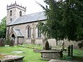
 / 53.31523; -1.99169 (St James' Church, Taxal)
St James, Taxal from south east.jpg
16th centuryThe oldest part of the church is the tower, the nave was rebuilt in 1825, and the church was restored in 1887–89. It is built in gritstone with a slate roof, and consists of a nave, a south porch, a chancel with a northeast vestry and a southeast organ chamber, and a west tower. The tower has three stages, diagonal buttresses, a west doorway with a pointed arch, over which is a three-light Perpendicular window, and on the south front is a clock face. The top stage contains two-light bell openings with Y-tracery, over which is an embattled parapet with pinnacles. [4] [5] II*
Yeardsley Hall
53°20′40″N1°59′32″W / 53.34431°N 1.99222°W / 53.34431; -1.99222 (Yeardsley Hall)
Yeardsley Hall.jpg
16th or early 17th centuryA large house that was extended by the addition of a wing in the 18th century, it in stone with string courses, a parapet, and a slate roof with coped gables and kneelers. The house mainly has two storeys, and an irregular plan. In the angle with the wing is a porch with a segmental-arched entrance, and there is an eight-light mullioned and transomed window. [6] II
Hockerley Hall Farmhouse
53°20′09″N1°59′23″W / 53.33576°N 1.98969°W / 53.33576; -1.98969 (Hockerley Hall Farmhouse)
Hockerley Hall.jpg
17th century (probable)The farmhouse is in stone and has a stone slate roof with ball finials. There are two storeys and four bays, the right bay gabled. On the front is a gabled porch with ball finials, and the windows are mullioned. [7] II
Lodgewood Cottages
53°19′05″N1°59′35″W / 53.31813°N 1.99318°W / 53.31813; -1.99318 (Lodgewood Cottages)
Lodgewood Cottages, Whaley Bridge.jpg
Mid 17th centuryA house, later divided into two, is in gritstone with quoins and a stone slate roof. There are two storeys and attics, and three bays, the outer bays gabled and projecting at the rear. The windows on the front are sashes, and elsewhere they are mullioned. [8] II
Oldfield Farm
53°17′52″N1°59′16″W / 53.29788°N 1.98765°W / 53.29788; -1.98765 (Oldfield Farm)
Oldfield Farmhouse.jpg
17th centuryA farmhouse and attached cottage in gritstone, with stone slate roofs, coped gables and moulded kneelers. There is an elongated L-shaped plan with an addition at the west end. The original doorway, which is blocked, has a quoined surround, a massive lintel and a hood mould. The windows in the original part either have a single light or are mullioned, and those in the addition are casements. [9] II
The Carr
53°19′25″N1°59′02″W / 53.32369°N 1.98394°W / 53.32369; -1.98394 (The Carr)
17th centuryA house that has been altered and extended, it is in rendered stone with a roof of stone slate, and Welsh slate on the extension. The house is mainly in three storeys, with windows of varying types. [10] II
Bings Farmhouse and barn
53°19′54″N1°58′44″W / 53.33168°N 1.97885°W / 53.33168; -1.97885 (Bings Farmhouse and barn)
Early 18th centuryThe farmhouse and attached barn are in stone with quoins and roofs mainly of stone slate. The house has two storeys and a projecting wing on the left. There is a blocked doorway with a shaped, initialled and dated lintel, above which is a small round-headed window. [11] II
42 Old Road
53°19′39″N1°58′57″W / 53.32751°N 1.98260°W / 53.32751; -1.98260 (42 Old Road)
1742A farmhouse, later a private house, it is in stone with a stone slate roof. There are two storeys and two bays. The door lintel is inscribed with initials and the date, there is one sash window and the other windows are modern replacements. [12] II
40 Old Road
53°19′39″N1°58′58″W / 53.32749°N 1.98273°W
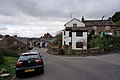
 / 53.32749; -1.98273 (40 Old Road)
Old Road, Whaley Bridge - geograph.org.uk - 3891536.jpg
18th centuryA house in painted stone used at one time as a mill. There are three storeys and an irregular plan. To the left of the doorway are two bay windows. [13] II
Rose Cottage
53°19′23″N1°59′00″W / 53.32299°N 1.98324°W / 53.32299; -1.98324 (Rose Cottage)
Old Road, Whaley Bridge.jpg
18th centuryA row of three stone cottages with a stone slate roof. There are two storeys and four bays. Some windows are sashes, and the others are replacements. The doorway of the middle cottage has a moulded surround, a shouldered architrave, a moulded cornice, and a pediment with modillions. [14] II
19–23 Old Road
53°19′38″N1°58′59″W / 53.32723°N 1.98298°W / 53.32723; -1.98298 (19–23 Old Road)
Late 18th centuryA farmhouse and outbuildings converted for residential use, the building is in stone with quoins and a Welsh slate roof. There are two storeys, four bays and a projecting single-storey outbuilding on the right. The windows are modern casements, and there is a modern porch. [15] II
Kishfield Bridge
53°19′23″N2°00′35″W / 53.32300°N 2.00979°W
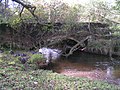
 / 53.32300; -2.00979 (Kishfield Bridge)
Kishfield Bridge.jpg
Late 18th century (probable)The bridge carries Start Lane over Todd Brook. It is in brown sandstone, and consists of a slightly recessed, low segmental arch. The bridge has a plain parapet with flat coping. [16] II
Horse tunnel
53°20′14″N1°58′50″W / 53.33732°N 1.98069°W / 53.33732; -1.98069 (Horse tunnel)
Horse Tunnel, Whaley Bridge.jpg
1794–1801 (presumed)An aqueduct carrying the Peak Forest Canal over a horse tunnel. It is in stone, and consists of a segmental arch with voussoirs. The retaining walls are concave, and have parapets that are coped on the north, and they end in piers. [17] II
New House Farmhouse
53°19′42″N2°00′39″W / 53.32838°N 2.01079°W / 53.32838; -2.01079 (New House Farmhouse)
New House Farm, Whaley Bridge, Derbyshire.JPG
1795The farmhouse is in stone with rusticated quoins and a stone slate roof. There are two storeys and three bays. On the front are two doorways, sash windows and an initialled datestone. [18] II
Carr Lodge
53°19′24″N1°59′00″W / 53.32327°N 1.98342°W / 53.32327; -1.98342 (Carr Lodge)
1802A stone house with quoins, two storeys and three bays, the left corner canted. The doorway and flanking windows have lintels with keystone. The date is on the wood surround under the lintel of the doorway. [19] II
Methodist Church and Sunday School
53°19′40″N1°59′01″W / 53.32764°N 1.98357°W / 53.32764; -1.98357 (Methodist Church and Sunday School)
Whaley Bridge Uniting Church - geograph.org.uk - 1816831.jpg
1821The church and Sunday school are in stone with rusticated quoins. The building is in three parts, the central part the earliest, with the chapel added to the left in 1867, and the schoolroom later to the right. The centre part has two storeys and three bay, with round-headed windows in the upper floor and in the ground floor are segmental -arched windows, and an arched doorway with a fanlight and a keystone. The chapel has a single storey and three bays, the middle bay gabled, and the schoolroom has three storeys and two bays. [20] [21] II
Canal Cottage and former stable block
53°19′52″N1°59′01″W / 53.33111°N 1.98374°W / 53.33111; -1.98374 (Canal Cottage and former stable block)
Canal Cottage, Whaley Bridge.jpg
Early 19th centuryThe cottage and former stable block are in painted stone with Welsh slate roofs and two storeys. The cottage has three bays, and contains sash windows, and two doorways with rectangular fanlights. The stable block attached to the left has two bays, with windows above carriage doors. [22] II
Milestone
53°20′34″N1°59′08″W / 53.34275°N 1.98562°W / 53.34275; -1.98562 (Milestone)
Milestone 1334779.jpg
Early 19th centuryThe milestone is on the west side of Buxton Road (A6 road). It consists of an upright stone slab with a round top, inscribed with the distances to Stockport and Buxton. [23] II
Taxal Rectory
53°18′54″N1°59′33″W / 53.31496°N 1.99253°W / 53.31496; -1.99253 (Taxal Rectory)
Early 19th centuryThe rectory, which possibly has earlier origins, is in painted stone. There are two storeys and three gabled bays, the left bay projecting. The windows are sashes, and the doorway has pilasters, a narrow entablature and flanking lights. [24] II
White Hart Public House
53°19′44″N1°59′00″W / 53.32888°N 1.98331°W / 53.32888; -1.98331 (White Hart Public House)
The White Hart - geograph.org.uk - 1816909.jpg
Early 19th centuryThe public house has an earlier core, and the front dates from later in the 19th century. It is in stone at the rear, and rendered, carved as stone and painted, on a plinth at the front, with quoins. There are two storeys and three bays, the left bay canted. The doorway has a small cornice, and the windows are sashes. [25] II
Canal Warehouse
53°19′53″N1°59′01″W / 53.33152°N 1.98366°W / 53.33152; -1.98366 (Canal Warehouse)
Canal transhipment warehouse, Whaley Bridge - geograph.org.uk - 450102.jpg
1832The warehouse, which was extended in 1916, straddles the canal, and was built for transhipment between the Peak Forest Canal and the High Peak Tramway. It is built in stone and has coped gables. There are three gabled bays, each containing a segmental arch with a rusticated surround and a keystone, the middle arch smaller. In the middle gable is a plaque, and along the sides are five windows. At the canal end is a boat entry in the middle, over which is a window and a hoist door. [20] [26] II*
Aqueduct Bridge
53°20′58″N1°59′20″W / 53.34958°N 1.98896°W / 53.34958; -1.98896 (Aqueduct Bridge)
Aqueduct, Furness Vale.jpg
Early to mid 19th centuryThe aqueduct carries the Peak Forest Canal over a stream. It is in stone, and consists of a round-headed arch with a cornice and a coped parapet. [27] II
Colliery Air Shaft Tower
53°19′38″N1°58′57″W / 53.32728°N 1.98250°W / 53.32728; -1.98250 (Colliery Air Shaft Tower)
Colliery winding house, Whaley Bridge - geograph.org.uk - 450110.jpg
Mid 19th centuryThe tower is in red sandstone, and has a parapet with triangular-shaped coping. There is a square plan, and it has a smaller square top. The tower contains various irregular window openings from its later use as storage premises. [2] [28] II
Railway bridge
53°19′38″N1°59′03″W / 53.32732°N 1.98422°W / 53.32732; -1.98422 (Railway bridge)
Whaley Bridge Railway Bridge - geograph.org.uk - 1816862.jpg
c. 1863The bridge was built by the Stockport, Disley and Whaley Bridge Railway to carry its line over Buxton Road (A5004 road). It is in cast iron with gritstone abutments, and consists of a single segmental arch with four iron ribs joined in the centre. The bridge has five rectangular headed openings in the spandrels, a cornice and a solid parapet. [29] II
Fernilee Methodist Chapel and railings
53°18′26″N1°58′31″W / 53.30736°N 1.97531°W / 53.30736; -1.97531 (Fernilee Methodist Chapel and railings)
1871The chapel is in blue brick with white brick quoins, and dressings in red and white brick. There are two storeys, an eaves cornice, and a gabled front. On the front is a gabled porch containing an arched entrance with pilasters. The porch is flanked by round-arched windows, and above it is a datestone. Along the sides are round-arched windows with impost and sill bands. In front of the chapel are low stone walls with railings, and over the entrance is a lamp holder and lamp. [20] [30] II
Holy Trinity Church and wall
53°19′29″N1°59′08″W / 53.32462°N 1.98546°W / 53.32462; -1.98546 (Holy Trinity Church and wall)
Holy Trinity Church, Whaley Bridge - geograph.org.uk - 2588540.jpg
1903–04The church, which was extended in 1922–23, is in gritstone with a slate roof. It has an irregular cruciform plan, consisting of a nave, a chancel, a north porch and vestries, and a south organ chamber. At the junction of the nave and chancel is a diagonally-set square bell tower with a shallow pyramidal roof. To the rear of the church is an attached boundary wall. [20] [31] II

Related Research Articles

Ballidon is a civil parish in the Derbyshire Dales district of Derbyshire, England. The parish contains 15 listed buildings that are recorded in the National Heritage List for England. All the listed buildings are designated at Grade II, the lowest of the three grades, which is applied to "buildings of national importance and special interest". The parish contains the villages of Ballidon and Pikehall, and Ballidon Quarry, and is otherwise entirely rural. Most of the listed buildings are farmhouses and farm buildings, two of which has been converted for other uses by the quarry. The other listed buildings are a church, a milestone, a lime kiln, and an embankment and bridge, originally carrying a railway, and later part of the High Peak Trail.

Bamford is a civil parish in the High Peak district of Derbyshire, England. The parish contains eight listed buildings that are recorded in the National Heritage List for England. Of these, one is listed at Grade II*, the middle of the three grades, and the others are at Grade II, the lowest grade. The parish contains the village of Bamford, and is otherwise rural. The listed buildings consist of a farmhouse and two associated barns, a bridge, and two churches with associated structures.

Barrow upon Trent is a civil parish in the South Derbyshire district of Derbyshire, England. The parish contains twelve listed buildings that are recorded in the National Heritage List for England. Of these, one is listed at Grade I, the highest of the three grades, and the others are at Grade II, the lowest grade. The parish contains the villages of Barrow upon Trent and Arleston and the surrounding countryside, and is mainly rural. The listed buildings include houses, two churches, a farmhouse, a bridge over the Trent and Mersey Canal, a former school, and a war memorial.

Castleton is a civil parish in the High Peak district of Derbyshire, England. The parish contains 25 listed buildings that are recorded in the National Heritage List for England. Of these, one is listed at Grade I, the highest of the three grades, one is at Grade II*, the middle grade, and the others are at Grade II, the lowest grade. The parish contains the village of Castleton and the surrounding countryside and moorland. The most important building in the parish is the ruined Peveril Castle, which is listed at Grade I. The other listed buildings include houses, cottages and associated structures, farmhouses and farm buildings, a church and a sundial in the churchyard, a hotel and a public house, a former watermill, three mileposts, a school, a war memorial, and a telephone kiosk.

Charlesworth is a civil parish in the High Peak district of Derbyshire, England. The parish contains 15 listed buildings that are recorded in the National Heritage List for England. All the listed buildings are designated at Grade II, the lowest of the three grades, which is applied to "buildings of national importance and special interest". The parish contains the village of Charlesworth and the surrounding countryside. Most of the listed buildings are houses and cottages, farmhouses and farm buildings. The other listed buildings are a bridge, a church, a chapel and its associated walls, and a war memorial.

Chinley, Buxworth and Brownside is a civil parish in the High Peak district of Derbyshire, England. The parish contains 29 listed buildings that are recorded in the National Heritage List for England. Of these, one is listed at Grade II*, the middle of the three grades, and the others are at Grade II, the lowest grade. The parish contains settlements, including the villages of Chinley and Buxworth, and is otherwise rural. Most of the listed buildings are farmhouses and farm buildings, houses, cottages and associated structures. The Peak Forest Canal ends in the parish at Bugsworth Basin, and two listed buildings are associated with it. The other listed buildings consist of a church and two chapels, and a pair of railway viaducts.

Church Broughton is a civil parish in the South Derbyshire district of Derbyshire, England. The parish contains ten listed buildings that are recorded in the National Heritage List for England. Of these, one is listed at Grade I, the highest of the three grades, and the others are at Grade II, the lowest grade. The parish contains the village of Church Broughton, and is otherwise rural. The listed buildings consist of a church, houses, cottages and associated structures, farmhouses, and farm buildings

Crich is a civil parish in the Amber Valley district of Derbyshire, England. The parish contains 52 listed buildings that are recorded in the National Heritage List for England. Of these, one is listed at Grade I, the highest of the three grades, one is at Grade II*, the middle grade, and the others are at Grade II, the lowest grade. The parish contains the villages of Crich, Fritchley, Whatstandwell, and Wheatcroft, and the surrounding countryside. Most of the listed buildings are houses, cottages and associated structures, farmhouses and farm buildings. In the parish is the National Tramway Museum, and a number of structures that have been moved from other sites to the museum are listed. The other listed buildings include churches and chapels, a bridge over the Cromford Canal and a road bridge over the River Derwent, public houses, buildings associated with tramways, a milepost, a village cross, a memorial tower, and a village telephone kiosk.

Dethick, Lea and Holloway is a civil parish in the Amber Valley district of Derbyshire, England. The parish contains 36 listed buildings that are recorded in the National Heritage List for England. Of these, five are listed at Grade II*, the middle of the three grades, and the others are at Grade II, the lowest grade. The parish contains the villages of Dethick, Lea, and Holloway, and the surrounding area. Most of the listed buildings are country houses, smaller houses, cottages, and associated structures. The other listed buildings include churches and chapels, a public house, farmhouses and farm buildings, and a bridge.

Edale is a civil parish in the High Peak district of Derbyshire, England. The parish contains 28 listed buildings that are recorded in the National Heritage List for England. All the listed buildings are designated at Grade II, the lowest of the three grades, which is applied to "buildings of national importance and special interest". The parish is almost entirely rural, consisting of countryside and moorland, and containing small settlements including Grindsbrook Booth and Barber Booth. Most of the listed buildings are houses, cottages, farmhouses and farm buildings. The other listed buildings include a church, a chapel, a public house, a sundial, two packhorse bridges, a former cotton mill, a war memorial, and a telephone kiosk.

Grindleford is a civil parish in the Derbyshire Dales district of Derbyshire, England. The parish contains 26 listed buildings that are recorded in the National Heritage List for England. Of these, one is listed at Grade I, the highest of the three grades, one is at Grade II*, the middle grade, and the others are at Grade II, the lowest grade. The parish contains the village of Grindleford and the surrounding countryside. Most of the listed buildings are houses, cottages and farmhouses and associated structures. The other listed buildings include a former gatehouse converted into a chapel, two bridges, a milestone and a milepost, a former cotton mill, a former toll house, and another chapel.

Hathersage is a civil parish in the Derbyshire Dales district of Derbyshire, England. The parish contains 54 listed buildings that are recorded in the National Heritage List for England. Of these, one is listed at Grade I, the highest of the three grades, three are at Grade II*, the middle grade, and the others are at Grade II, the lowest grade. The parish, which is almost entirely rural, contains the village of Hathersage and the surrounding countryside. Most of the listed buildings are farmhouses and farm buildings, houses, cottages, and associated structures. The other listed buildings include two churches, a cross shaft in a churchyard, a presbytery and a vicarage, two bridges, former mills, a milepost, a former toll house, a railway viaduct, and a lamp column.

Hognaston is a civil parish in the Derbyshire Dales district of Derbyshire, England. The parish contains nine listed buildings that are recorded in the National Heritage List for England. Of these, one listed at Grade II*, the middle of the three grades, and the others are at Grade II, the lowest grade. The parish contains the village of Hognaston and the surrounding area. The listed buildings consist of houses, cottages, farmhouses, a church, and a telephone kiosk.

Newton Solney is a civil parish in the South Derbyshire district of Derbyshire, England. The parish contains 19 listed buildings that are recorded in the National Heritage List for England. Of these, two are listed at Grade II*, the middle of the three grades, and the others are at Grade II, the lowest grade. The parish contains the village of Newton Solney and the surrounding area. Most of the listed buildings are houses, cottages and associated structures, farmhouses and farm buildings. The other listed buildings include a church, follies, a hotel and a public house, a row of almshouses, and part of a model farm.

Peak Forest is a civil parish in the High Peak district of Derbyshire, England. The parish contains eight listed buildings that are recorded in the National Heritage List for England. All the listed buildings are designated at Grade II, the lowest of the three grades, which is applied to "buildings of national importance and special interest". The parish contains the village of Peak Forest, and is otherwise rural. Most of the listed buildings are farmhouses and farmbuildings, and the others consist of mileposts, a church and a reading room.

Risley is a civil parish in the Borough of Erewash in Derbyshire, England. The parish contains 17 listed buildings that are recorded in the National Heritage List for England. Of these, five are listed at Grade II*, the middle of the three grades, and the others are at Grade II, the lowest grade. The parish contains the village of Risley and the surrounding area. The listed buildings include a country house and structures in its grounds, a church and items in the churchyard, smaller houses, buildings associated with a school, a farmhouse and barn, and two mileposts.

Stanton by Bridge is a civil parish in the South Derbyshire district of Derbyshire, England. The parish contains twelve listed buildings that are recorded in the National Heritage List for England. Of these, two are listed at Grade I, the highest of the three grades, and the others are at Grade II, the lowest grade. The parish contains the village of Stanton by Bridge and the surrounding area. The listed buildings consist of a church, a bridge and causeway, houses and associated structures, farmhouses and a farm building.

Twyford and Stenson is a civil parish in the South Derbyshire district of Derbyshire, England. The parish contains twelve listed buildings that are recorded in the National Heritage List for England. Of these, one is listed at Grade I, the highest of the three grades, one is at Grade II*, the middle grade, and the others are at Grade II, the lowest grade. The parish contains the villages of Twyford and Stenson and the surrounding countryside. The Trent and Mersey Canal runs through the north of the parish, and the listed buildings associated with it are bridges, a lock and a cottage. The other listed buildings are a church, houses, cottages and associated structures, and farmhouses and farm buildings.

Wheston is a civil parish in the Derbyshire Dales district of Derbyshire, England. The parish contains seven listed buildings that are recorded in the National Heritage List for England. Of these, one is listed at Grade II*, the middle of the three grades, and the others are at Grade II, the lowest grade. The parish contains the village of Wheston and the surrounding area. All the listed buildings are in the village, and consist of farmhouses, farm buildings and the village cross.

Wingerworth is a civil parish in the North East Derbyshire district of Derbyshire, England. The parish contains 20 listed buildings that are recorded in the National Heritage List for England. Of these, one is listed at Grade I, the highest of the three grades, one is at Grade II*, the middle grade, and the others are at Grade II, the lowest grade. The parish contains the village of Wingerworth and the surrounding countryside. Most of the listed buildings are houses, cottages and associated structures, farmhouses and farm buildings. The other listed buildings include churches, a public house, a pair of lodges and associated structures, two mileposts, and a bridge with an associated sheepwash.

References

Citations

Sources