Little Falls-South Windham, Maine

Last updated
Little Falls-South Windham, Maine
USA Maine location map.svg
Red pog.svg
Little Falls-South Windham, Maine
Location within the state of Maine
Coordinates: 43°43′54″N70°25′13″W / 43.73167°N 70.42028°W / 43.73167; -70.42028 Coordinates: 43°43′54″N70°25′13″W / 43.73167°N 70.42028°W / 43.73167; -70.42028
Country United States
State Maine
County Cumberland
Area
  Total2.5 sq mi (6.5 km2)
  Land2.4 sq mi (6.1 km2)
  Water0.1 sq mi (0.3 km2)
Population
 (2000)
  Total1,792
  Density754.9/sq mi (291.5/km2)
Time zone UTC-5 (Eastern (EST))
  Summer (DST) UTC-4 (EDT)
Area code 207
FIPS code 23-40367

Little Falls-South Windham was a census-designated place (CDP) in Cumberland County, Maine, United States defined for the 2000 census. The population of the CDP was 1,792 at the time. Because of new CDP guidelines for 2010, the CDP has been split into two CDPs: Little Falls and South Windham.

Contents

It is part of the Portland South Portland Biddeford, Maine Metropolitan Statistical Area.

Geography

Little Falls-South Windham is located at 43°43′54″N70°25′13″W / 43.73167°N 70.42028°W / 43.73167; -70.42028 (43.731790, -70.420378). [1]

According to the United States Census Bureau, the CDP had a total area of 2.5 square miles (6.5 km2), of which 2.4 square miles (6.2 km2) was land and 0.1 square miles (0.26 km2), or 5.18%, was water.

It was divided between the towns of Gorham (the Little Falls side) and Windham (the South Windham side), and straddles the Presumpscot River.

Demographics

As of the census [2] of 2000, there were 1,792 people, 491 households, and 341 families residing in the CDP. The population density was 754.9 inhabitants per square mile (291.5/km2). There were 521 housing units at an average density of 219.5 per square mile (84.7/km2). The racial makeup of the CDP was 95.93% White, 1.67% African American, 0.84% Native American, 0.33% Asian, 0.06% Pacific Islander, 0.06% from other races, and 1.12% from two or more races. Hispanic or Latino of any race were 0.78% of the population.

There were 491 households, out of which 35.8% had children under the age of 18 living with them, 51.3% were married couples living together, 14.7% had a female householder with no husband present, and 30.5% were non-families. 21.8% of all households were made up of individuals, and 6.1% had someone living alone who was 65 years of age or older. The average household size was 2.53 and the average family size was 2.98.

In the CDP the population was spread out, with 18.3% under the age of 18, 13.8% from 18 to 24, 43.1% from 25 to 44, 17.6% from 45 to 64, and 7.2% who were 65 years of age or older. The median age was 34 years. For every 100 females, there were 163.9 males. For every 100 females age 18 and over, there were 183.2 males.

The median income for a household in the CDP was $42,639, and the median income for a family was $50,500. Males had a median income of $32,000 versus $21,983 for females. The per capita income for the CDP was $14,377. About 2.6% of families and 5.2% of the population were below the poverty line, including 4.3% of those under age 18 and none of those age 65 or over.

Related Research Articles

<span class="mw-page-title-main">Sterling, Connecticut</span> Town in Connecticut, United States

Sterling is a town in Windham County, Connecticut, United States. The population was 3,578 at the 2020 census.

<span class="mw-page-title-main">Wainaku, Hawaii</span> Census-designated place in Hawaii, U.S.

Wainaku is a census-designated place (CDP) in Hawaiʻi County, Hawaiʻi, United States. The population was 1,147 at the 2020 census.

<span class="mw-page-title-main">North Windham, Maine</span> Census-designated place in Maine, United States

North Windham is a census-designated place (CDP) within the town of Windham in Cumberland County, Maine, United States. The population was 4,904 at the 2010 census. It is part of the Portland–South Portland–Biddeford, Maine Metropolitan Statistical Area.

Chisholm is a census-designated place (CDP) in the town of Jay in Franklin County, Maine, United States. The population was 1,380 at the 2010 census. It is an industrial village named for Hugh J. Chisholm, who built the Otis Falls Pulp & Paper Company here in 1888 to use Androscoggin River water power.

<span class="mw-page-title-main">Limington, Maine</span> Town in the state of Maine, United States

Limington is a town in York County, Maine, United States. The population was 3,892 at the 2020 census. Limington is a tourist destination with historic architecture. It is part of the Portland–South Portland–Biddeford, Maine metropolitan statistical area.

<span class="mw-page-title-main">Seconsett Island, Massachusetts</span> Census-designated place in Massachusetts, United States

Seconsett Island is a census-designated place (CDP) in the town of Mashpee in Barnstable County, Massachusetts, United States. The population was 100 at the 2010 census.

<span class="mw-page-title-main">Quinnesec, Michigan</span> Census-designated place & unincorporated community in Michigan, United States

Quinnesec is an unincorporated community in Dickinson County in the U.S. state of Michigan. It is a census-designated place (CDP) for statistical purposes and has no legally recognized status as a municipality. The population was 1,191 at the 2010 census. It is part of the Iron Mountain, MI–WI Micropolitan Statistical Area.

<span class="mw-page-title-main">Oscoda Township, Michigan</span> Charter township in Michigan, United States

Oscoda Township is a charter township of Iosco County in the U.S. state of Michigan. The population was 6,788 at the 2020 census. The Wurtsmith Air Force Base is located within the township.

<span class="mw-page-title-main">Buena Vista, Michigan</span> Census-designated place & unincorporated community in Michigan, United States

Buena Vista is an unincorporated community within Buena Vista Charter Township, Saginaw County in the U.S. state of Michigan. The U.S. Census Bureau has defined a census-designated place (CDP) with the same name for statistical purposes. The CDP has no official status as a municipality and the boundaries defined by the Census Bureau may not precisely correspond to local understanding of the Buena Vista area. The CDP consists of an area adjacent to the city of Saginaw on its east side and mostly east of Interstate 75. The population was 7,845 at the 2000 census.

<span class="mw-page-title-main">South Woodstock, Connecticut</span> Census-designated place in Connecticut, United States

South Woodstock is a village and census-designated place (CDP) in Woodstock, Windham County, Connecticut, United States. The population was 1,291 at the 2010 census.

<span class="mw-page-title-main">South Hill, New York</span> CDP in New York, United States

South Hill is a census-designated place (CDP) in Tompkins County, New York, United States. The population was 7,245 at the 2020 census.

<span class="mw-page-title-main">Valley View, Schuylkill County, Pennsylvania</span> CDP in Pennsylvania, United States

Valley View is a census-designated place (CDP) in Schuylkill County, Pennsylvania, United States. The population was 1,677 at the 2000 census.

Lynnwood-Pricedale is a census-designated place (CDP) in Fayette and Westmoreland counties in the commonwealth of Pennsylvania, United States. The population was 2,031 at the 2010 census, down from 2,168 at the 2000 census. The community of Lynwood is located in Fayette County's Washington Township, while Pricedale is part of Westmoreland County's Rostraver Township.

<span class="mw-page-title-main">Kennebunkport (CDP), Maine</span> Census-designated place in Maine, United States

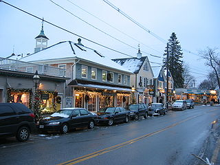
Kennebunkport is a census-designated place (CDP) consisting of the central village in the town of Kennebunkport in York County, Maine, United States. The population was 1,238 at the 2010 census, out of a total town population of 3,474. It is part of the Portland–South Portland–Biddeford, Maine Metropolitan Statistical Area.

<span class="mw-page-title-main">Londonderry (CDP), New Hampshire</span> Census-designated place in New Hampshire, United States

Londonderry is a census-designated place (CDP) within the town of Londonderry in Rockingham County, New Hampshire, United States. The population of the CDP was 11,645 at the 2020 census, out of 25,826 in the entire town.

Windham is a hamlet and census-designated place (CDP) in the town of Windham, Greene County, New York, United States. The population of the CDP was 367 at the 2010 census, out of a total of 1,703 people in the town.

<span class="mw-page-title-main">Livermore Falls (CDP), Maine</span> Census-designated place in Maine, United States

Livermore Falls is a census-designated place (CDP) in the town of Livermore Falls in Androscoggin County, Maine, United States. The population of the CDP was 1,594 at the 2010 census, out of a population of 3,187 within the full town.

<span class="mw-page-title-main">Mechanic Falls (CDP), Maine</span> Census-designated place in Maine, United States

Mechanic Falls is a census-designated place (CDP) in the town of Mechanic Falls in Androscoggin County, Maine, United States. The population of the CDP was 2,237 at the 2010 census, out of a total town population of 3,031.

<span class="mw-page-title-main">Yarmouth (CDP), Maine</span> Census-designated place in Maine, United States

Yarmouth is a census-designated place (CDP) in the town of Yarmouth in Cumberland County, Maine, United States. The population was 5,869 at the 2010 census. It is part of the Portland–South Portland–Biddeford, Maine Metropolitan Statistical Area.

<span class="mw-page-title-main">Berwick (CDP), Maine</span> Census-designated place in Maine, United States

Berwick is a census-designated place (CDP) in the town of Berwick in York County, Maine, United States. The population was 2,187 at the 2010 census, out of a total of 7,246 in the entire town. It is part of the Portland–South Portland–Biddeford, Maine Metropolitan Statistical Area.

References

  1. "US Gazetteer files: 2010, 2000, and 1990". United States Census Bureau. 2011-02-12. Retrieved 2011-04-23.
  2. "U.S. Census website". United States Census Bureau . Retrieved 2008-01-31.