Little Rock, Beltrami County, Minnesota

Last updated

Little Rock
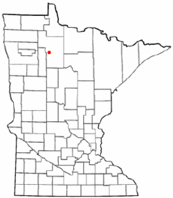
MNMap-doton-Little Rock.png
Location of Little Rock within Beltrami County
Coordinates: 47°52′05″N95°06′38″W / 47.86806°N 95.11056°W / 47.86806; -95.11056
Country United States
State Minnesota
County Beltrami
Area
[1]
  Total7.54 sq mi (19.54 km2)
  Land7.21 sq mi (18.68 km2)
  Water0.33 sq mi (0.86 km2)
Elevation
1,197 ft (365 m)
Population
 (2020)
  Total1,021
  Density141.55/sq mi (54.65/km2)
Time zone UTC-6 (Central (CST))
  Summer (DST) UTC-5 (CDT)
Area code 218
FIPS code 27-37656
GNIS feature ID1867327 [2]

Little Rock (Ojibwe : Gaa-Asiniinsikaag) [3] is a census-designated place (CDP) within the Lower Red Lake unorganized territory in Beltrami County, Minnesota, United States. The population was 1,208 at the 2010 census. [4]

Contents

Geography

According to the United States Census Bureau, the CDP has a total area of 7.5 square miles (19.6 km2), of which 7.2 square miles (18.7 km2) is land and 0.3 square mile (0.9 km2) (4.38%) is water.

Demographics

Historical population
CensusPop.Note
2000 1,055
2010 1,20814.5%
2020 1,021−15.5%
U.S. Decennial Census [5]

As of the census [6] of 2000, there were 1,055 people, 281 households, and more than 234 families residing in the CDP. The population density was 80.9 inhabitants per square mile (31.2/km2). There were 298 housing units at an average density of 22.8/sq mi (8.8/km2). The racial makeup of the CDP was 0.76% White, 0.09% Black or African American, 98.86% Native American, and 0.28% from two or more races. Hispanic or Latino of any race were 1.90% of the population.

There were 281 households, out of which 54.4% had children under the age of 18 living with them, 26.7% were married couples living together, 38.1% had a female householder with no husband present, and 16.7% were non-families. 12.8% of all households were made up of individuals, and 3.9% had someone living alone who was 65 years of age or older. The average household size was 3.75 and the average family size was 3.91.

In the CDP, the population was spread out, with 45.4% under the age of 18, 11.5% from 18 to 24, 26.5% from 25 to 44, 12.1% from 45 to 64, and 4.5% who were 65 years of age or older. The median age was 20 years. For every 100 females, there were 94.3 males. For every 100 females age 18 and over, there were 88.9 males.

The median income for a household is $25,688, and the median income for a family was $20,893. Males had a median income of $24,167 versus $23,542 for females. The per capita income for the CDP was $8,668. About 30.1% of families and 31.8% of the population were below the poverty line, including 41.1% of those under age 18 and 22.2% of those age 65 or over.

Education

It is in the Red Lake School District, [7] which operates Red Lake Elementary Complex and Red Lake Secondary Complex (formerly Red Lake High School).

Related Research Articles

<span class="mw-page-title-main">Tonalea, Arizona</span> CDP in Coconino County, Arizona

Tonalea is a census-designated place (CDP) in Coconino County, Arizona, United States. The population was 549 at the 2010 census. It has also been known as Red Lake.

<span class="mw-page-title-main">Channel Lake, Illinois</span> Census-designated place in Illinois, United States

Channel Lake is an unincorporated community and census-designated place (CDP) in Antioch Township, Lake County, Illinois, United States. Per the 2020 census, the population was 1,581.

Fox Lake Hills is an unincorporated community and census-designated place (CDP) in Lake Villa Township, Lake County, Illinois, United States. Per the 2020 census, the population was 2,684.

Long Lake is an unincorporated community and census-designated place (CDP) in Lake County, Illinois, United States. Per the 2020 census, the population was 3,663.

<span class="mw-page-title-main">Lakeland Village, California</span> Census-designated place in California, United States

Lakeland Village is a census-designated place (CDP) in Riverside County, California, United States. The population was 11,541 at the 2010 census, more than double the 5,626 reported at the 2000 census.

<span class="mw-page-title-main">Ponemah, Minnesota</span> Census-designated place in Minnesota, US

Ponemah is a census-designated place (CDP) within the Lower Red Lake unorganized territory in Beltrami County, Minnesota, United States. The population was 724 at the 2010 census.

<span class="mw-page-title-main">Red Lake, Minnesota</span> Census-designated place in Minnesota, US

Red Lake is a census-designated place (CDP) within the Lower Red Lake unorganized territory located in Beltrami County, Minnesota, United States. As of the 2020 census, Red Lake had a total population of 1,786. The Red Lake Indian Reservation is based in Red Lake.

<span class="mw-page-title-main">Redby, Minnesota</span> Census-designated place in Minnesota, US

Redby Ojibwe: Madaabiimog) is a census-designated place (CDP) within the Lower Red Lake unorganized territory in Beltrami County, Minnesota, United States. The population was 1,334 at the 2010 census.

<span class="mw-page-title-main">Pike Bay Township, Cass County, Minnesota</span> Township in Minnesota, United States

Pike Bay Township is a township in Cass County, Minnesota, United States. The population was 1,643 as of the 2000 census. Pike Bay Township was named for Pike Bay of Cass Lake, and indirectly for Zebulon Pike, an explorer.

<span class="mw-page-title-main">Arnold, Minnesota</span> Census-designated place in Minnesota, US

Arnold is a former census-designated place (CDP), which was located in Rice Lake, Saint Louis County, Minnesota, United States. The population was 2,960 at the 2010 census. The census-designated place of Arnold was located entirely within the former Rice Lake Township, adjacent to the north side of the city of Duluth. Rice Lake Township was incorporated as the city of Rice Lake on October 22, 2015, thus rendering the census-designated place of Arnold to no longer exist.

<span class="mw-page-title-main">Sutcliffe, Nevada</span> CDP in Nevada, United States

Sutcliffe is a census-designated place (CDP) in Washoe County, Nevada, United States. The population was 253 at the 2010 census. It is part of the Reno–Sparks Metropolitan Statistical Area.

<span class="mw-page-title-main">Lake Katrine, New York</span> CDP in New York, United States

Lake Katrine is a hamlet in Ulster County, New York, United States. The population was 2,522 at the 2020 census.

<span class="mw-page-title-main">Lake Wynonah, Pennsylvania</span> CDP in Pennsylvania, United States

Lake Wynonah is a census-designated place (CDP) in Schuylkill County, Pennsylvania, United States. The population was 1,961 at the 2000 census, and 2,640 at the 2010 census. Lake Wynonah is a gated community with two lakes, Fawn Lake and Lake Wynonah, and as of July 2008, there are over 1200 homes and 1500 members. It is in South Manheim and Wayne Townships.

Ravine is a census-designated place (CDP) in Schuylkill County, Pennsylvania, United States. The population was 629 at the 2000 census.

<span class="mw-page-title-main">Red Bank, South Carolina</span> Census-designated place in South Carolina, United States

Red Bank is an unincorporated community and census-designated place (CDP) in Lexington County, South Carolina, United States. The population was 9,617 at the 2010 census, up from 8,811 at the 2000 census. It is part of the Columbia, South Carolina Metropolitan Statistical Area.

<span class="mw-page-title-main">Colonial Pine Hills, South Dakota</span> CDP in South Dakota, United States

Colonial Pine Hills is a census-designated place (CDP) and unincorporated community in Pennington County, South Dakota, United States. The population was 1,903 at the 2020 census.

<span class="mw-page-title-main">Lake Stickney, Washington</span> CDP in Washington, United States

Lake Stickney is a census-designated place (CDP) in Snohomish County, Washington, United States. The population was 15,413 at the 2020 census. The CDP was known as Paine Field-Lake Stickney prior to 2010. The new Lake Stickney CDP no longer contains the Paine Field airport.

<span class="mw-page-title-main">Tainter Lake, Wisconsin</span> CDP in Wisconsin, United States

Tainter Lake is a census-designated place (CDP) in part of the Town of Tainter, Dunn County, Wisconsin, and part of the Town of Red Cedar, Dunn County, Wisconsin, United States. The population was 2,550 at the 2020 census.

<span class="mw-page-title-main">Potter Lake, Wisconsin</span> CDP in Wisconsin, United States

Potter Lake is a census-designated place (CDP) in the town of East Troy, Walworth County, Wisconsin, United States. The population was 1,117 at the 2020 census.

Lower Red Lake is an unorganized territory in Beltrami County, Minnesota, United States.The territory is located on the Red Lake Indian Reservation, and the town of Red Lake is located in the area. The population of the Lower Red Lake territory was 5,790 at the 2010 census.

References

  1. "2020 U.S. Gazetteer Files". United States Census Bureau. Retrieved July 24, 2022.
  2. "Little Rock, Beltrami County, Minnesota". Geographic Names Information System . United States Geological Survey, United States Department of the Interior.
  3. "Red Lake Nation - Home of the Red Lake Band of Chippewa Indians". Red Lake Nation. Retrieved April 12, 2023.
  4. "U.S. Census website". United States Census Bureau . Retrieved May 14, 2011.
  5. "Census of Population and Housing". Census.gov. Retrieved June 4, 2016.
  6. "U.S. Census website". United States Census Bureau . Retrieved January 31, 2008.
  7. "2020 CENSUS - SCHOOL DISTRICT REFERENCE MAP: Beltrami County, MN" (PDF). U.S. Census Bureau. Archived (PDF) from the original on August 12, 2021. Retrieved August 12, 2021.