Llanyblodwel

Last updated

Llanyblodwel
Horseshoe Inn Llanyblodwell - geograph.org.uk - 1802407.jpg
The Horseshoe Inn and bridge across the Tanat, Llanyblodwel
Shropshire UK location map.svg
Red pog.svg
Llanyblodwel
Location within Shropshire
Population767 (2011)
OS grid reference SJ240229
Civil parish
  • Llanyblodwel
Unitary authority
Ceremonial county
Region
Country England
Sovereign state United Kingdom
Post town OSWESTRY
Postcode district SY10
Dialling code 01691
Police West Mercia
Fire Shropshire
Ambulance West Midlands
UK Parliament
List of places
UK
England
Shropshire
52°47′53″N3°07′34″W / 52.798°N 3.126°W / 52.798; -3.126

Llanyblodwel is a village and civil parish in Shropshire, England; the spelling "Llanyblodwell" was commonly used in the past, and the village was sometimes simply referred to as "Blodwel". The population of the civil parish at the 2011 census was 767. [1] It lies 7 miles west of the nearest town, Oswestry, in the valley of the River Tanat. [2] Simon Jenkins, in his guide to English churches says of Llanyblodwel that "the Welsh Marches are seldom so lovely as where the River Tanat crosses the border through the steep wooded valleys west of Oswestry." [3]

Contents

The parish had a population of 817 at the time of the 2001 census. [4] It was formerly in the Llanyblodwel and Pant ward of the borough of Oswestry. The village is located in a scenic rural area, with attractive views of the Welsh hills across the border. There were formerly several limestone quarries around Llanyblodwel, and limited quarrying still takes place.

Etymology, history

The name is possibly a mixture of English and Welsh. Llan translates as "church" or "parish", so Llanyblodwel means "the church at Blodwel": a tributary of the Tanat was formerly known as the Blodwell, a name with a probable Old English root. [5]

The church itself may have Norman origins. The parish, on which the boundaries of the current civil parish were based, included the townships of Blodwell, Abertanat, Bryn, Moreton, and Llynclys. [6]

There was historically a strong Welsh cultural and linguistic influence in the area. In a lecture given in 1878, the geographer E G Ravenstein noted that of 2,469 inhabitants of the parishes of Selattyn and Llanyblodwel, 900 spoke Welsh. It was, however, declining at this time: "in Llanyblodwell Welsh preponderates [but] the children of Welsh parents are often unable to speak Welsh. The Welsh service in the parish church has been discontinued since 1875, owing to a paucity of attendance". [7]

Architecture

In the centre of the village is a listed [8] narrow stone bridge over the Tanat, built in 1710.

St Michael the Archangel church St Michael the Archangel, Llanyblodwel (geograph 2243579).jpg
St Michael the Archangel church

The grade I listed [9] parish church of St Michael the Archangel was heavily rebuilt in the mid 19th century to designs by its then-vicar, the Rev. John Parker. The design has been referred to in the Pevsner Architectural Guides as "bizarre", but "unforgettable", particularly the tower, which was apparently modelled on that of Freiburg Minster. [10] On the other hand, Jenkins describes the church as having been built "for strength on a difficult site" and acknowledging that this was in no sense a scholarly work but "...hobby architecture, a Gothic Portmeirion." [11] The interior is even more unconventional, with many texts and stencilled patterns. There is a 14th-century monumental slab in the south porch carved with a coursing hare, which some antiquaries have tried to connect with the hare iconography seen at Pennant Melangell, which once received the tithes of the township of Bryn. [12] The church contains a memorial [13] to Elias Owen (1833–1899), the Welsh antiquarian and author of "Welsh Folklore", published in 1887, who was incumbent at the church from 1892 until his death. [14] There are also a number of monuments to the Tanat and Bridgeman families in the church.

Llanyblodwel's timber-framed pub, the Horse Shoe Inn, is of late-mediaeval date and like several other buildings in the village is grade II listed. [12] [15]

There was once a substantial manor house, the seat of the Tanat family, near to the village at Blodwell Hall. [16] In the 15th century it had been the home of their ancestor, Gwerful ferch Madog, known as Gwerful Hael ("Gwerful the Bountiful") for her generosity and often mentioned in Welsh poetry of the time. [17] Sir John Bridgeman, who had married Ursula Matthews, the heiress of the Tanat estate, constructed a new house on the site in around 1700, along with formal gardens. [18] The site of the house is now occupied by a dairy farm, but an entrance gateway and a stone-built summerhouse dated 1718 still survive.

Railways

Blodwell Junction Station in 1962 Blodwell Junction Station 1836071 cf4580bb.jpg
Blodwell Junction Station in 1962

Despite its remote rural location, the village was once served by a railway station (Llanyblodwell Halt) on the Tanat Valley Railway, and the Potteries, Shrewsbury and North Wales Railway also ran through the area, serving Blodwell Junction station a mile east of the village. [19] Part of the line was still used for quarry trains until 1988, and sections are currently in the process of being restored as a heritage railway.

The Cambrian Heritage Railway based in Oswestry applied for a Transport & Works Act Order for transfer of NR's residual rights to itself and this was granted on 28 February 2017. This permits the CHR to reopen the route from Gobowen to Blodwel Quarry subject to level crossings of the A5 and A483 being replaced by a tunnel and overbridge respectively. [20]

See also

Related Research Articles

<span class="mw-page-title-main">Oswestry</span> Town in Shropshire, England

Oswestry is a market town, civil parish and historic railway town in Shropshire, England, close to the Welsh border. It is at the junction of the A5, A483 and A495 roads.

<span class="mw-page-title-main">Welshpool</span> Town in Powys, Wales

Welshpool is a market town and community in Powys, Wales, historically in the county of Montgomeryshire. The town is four miles from the Wales–England border and low-lying on the River Severn; its Welsh language name Y Trallwng means "the marshy or sinking land". The community includes Cloddiau and Pool Quay.

<span class="mw-page-title-main">Llanrhaeadr-ym-Mochnant</span> Human settlement in Wales

Llanrhaeadr-ym-Mochnant is a village, community and an ecclesiastical parish in the extreme north of Powys, Wales; about 9 miles west of Oswestry and 12 miles south of Llangollen, on the B4580. It lies near the foothills of the Berwyn mountains on the river Rhaeadr. At the top end of the valley is the Pistyll Rhaeadr waterfall, one of the Seven Wonders of Wales in the old rhyme. One mile north of the town is the hill Moel Hen-fache. The community includes the hamlet of Llanarmon Mynydd Mawr.

<span class="mw-page-title-main">Llanymynech</span> Village straddling the England-Wales border

Llanymynech is a village and former civil parish straddling the border between Montgomeryshire/Powys, Wales, and Shropshire, England, about 9 miles (14 km) north of the Welsh town of Welshpool. The name is Welsh for "Church of the Monks". The village is on the banks of the River Vyrnwy, and the Montgomery Canal passes through it.

<span class="mw-page-title-main">Cambrian Heritage Railways</span> Heritage railway in Shropshire, England

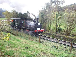
The Cambrian Heritage Railways is a heritage railway company, trust and society based at both Llynclys and Oswestry in its newly restored Oswestry railway station, Shropshire, England.

<span class="mw-page-title-main">Rail transport in Shropshire</span> Overview of rail transport in Shropshire, England

The English county of Shropshire has a fairly large railway network, with 19 National Rail stations on various national lines; there are also a small number of heritage and freight lines, including the famous heritage Severn Valley Railway running along its eastern border with Worcestershire.

<span class="mw-page-title-main">Nantmawr</span> Human settlement in England

Nantmawr is a village in Shropshire, England. It is located about 5 miles south west of Oswestry and close to the Welsh border. The Offa's Dyke Path runs through the village.

<span class="mw-page-title-main">Kinnerley</span> Human settlement in England

Kinnerley is a small village in Shropshire, England. It lies between the neighbouring villages of Dovaston and Pentre and the nearest town is Oswestry. To the north is the village of Knockin.

<span class="mw-page-title-main">Llynclys</span> Human settlement in England

Llynclys ) is a small village in Shropshire, England, in the civil parish of Llanyblodwel. It lies north of Pant at the crossroads of the A483 and B4396, where there are several houses and a pub, the White Lion.

<span class="mw-page-title-main">Grinshill</span> Human settlement in England

Grinshill is a small village, and civil parish in Shropshire, England, United Kingdom. The parish is one of the smallest in the district. The population of the civil parish at the 2011 census was 274. Grinshill Hill rises above the village to 192 metres (630 ft) above sea level.

<span class="mw-page-title-main">Llansantffraid-ym-Mechain</span> Human settlement in Wales

Llansantffraid-ym-Mechain is a large village in Powys, Mid Wales, close to the border with Shropshire in England, about 7 miles (11 km) south-west of Oswestry and 8 miles (13 km) north of Welshpool. It is on the A495 road and is at the confluence of the River Vyrnwy and the River Cain. The population as of the 2011 UK census was 1,415. The community includes the village of Deuddwr and several hamlets.

<span class="mw-page-title-main">Tanat Valley Light Railway</span>

The Tanat Valley Light Railway (TVLR) was a 15-mile (24 km) long standard gauge light railway. It ran westwards from Llanyblodwel in Shropshire, about 5 miles or 8 km south-west of Oswestry. It crossed the Wales–England border and continued up the Tanat valley, terminating at Llangynog in Powys. It opened in 1904, providing access to a fairly remote area, and transport facilities for slate production and agriculture.

<span class="mw-page-title-main">Selattyn</span> Human settlement in England

Selattyn is a village and former civil parish, now in the parish of Selattyn and Gobowen, in the Shropshire district, in the ceremonial county of Shropshire, England. It is on the England–Wales border, close to Oswestry. In 1961 the parish had a population of 1830. On 1 April 1967 the parish was abolished to form "Selattyn and Gobowen", part also went to Whittington.

<span class="mw-page-title-main">Elias Owen (priest)</span>

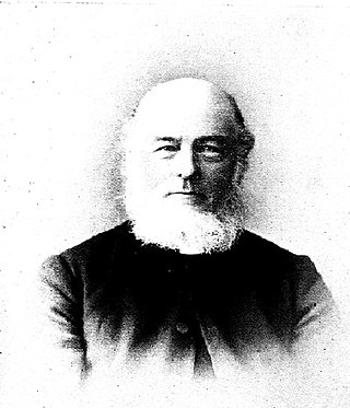
Rev. Elias Owen MA, F.S.A. was a Welsh cleric and antiquarian whose works include The Old Stone Crosses of the Vale of Clwyd, 1886 and Welsh Folk-Lore, 1896.

<span class="mw-page-title-main">Llanfyllin Branch</span>

The Llanfyllin Branch was a railway line extension of the Oswestry and Newtown Railway to access the limestone resources within the Llanfyllin area; it opened in 1863.

<span class="mw-page-title-main">St Michael the Archangel, Llanyblodwel</span> Church in Shropshire, England

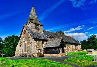
St Michael the Archangel is a Grade I listed church in Llanyblodwel, in Shropshire, England. It has a spire of unusual shape and was designed in 1847–1856 by the vicar, John Parker.

<span class="mw-page-title-main">Blodwell Junction railway station</span> Disused railway station in Llanyblodwell, Shropshire

Blodwell Junction railway station was a station in Llanyblodwel, Shropshire, England. The station opened on 18 April 1870 as Llanyblodwel before being renamed in 1904. The station closed to passengers on 15 January 1951 and closed completely on 6 January 1964. There is no trace of the station today.

<span class="mw-page-title-main">Porthywaen Halt railway station</span> Former railway station in Porth-y-waen, Shropshire, England

Porthywaen Halt railway station was a station in Porth-y-waen, Shropshire, England, on the Tanat Valley Railway and the Potteries, Shrewsbury and North Wales Railway. The station opened in 1904 and closed in 1951. The short platform had a shelter and there was also signal box at the east end which controlled access to the quarry branches. Cambrian Heritage Railways has plans to re-open the station as part of its aim of reopening the line from Gobowen to Blodwel. The platform is still extant.

<span class="mw-page-title-main">John Parker (cleric)</span> Welsh cleric and artist (1798–1860)

John Parker was a Welsh cleric and artist. Second son of Thomas Netherton Parker and his wife Sarah Browne of Sweeney Hall, Oswestry, Shropshire, he was educated at Eton College and Oriel College, Oxford. Author of poem "The Passengers: Containing, the Celtic Annals.", published 1831.

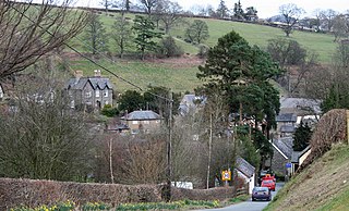
Llanyblodwel is a civil parish in Shropshire, England. It contains 49 listed buildings that are recorded in the National Heritage List for England. Of these, one is listed at Grade I, the highest of the three grades, one is at Grade II*, the middle grade, and the others are at Grade II, the lowest grade. The parish contains the village of Llanyblodwel and smaller settlements, and is otherwise rural. Most of the listed buildings are houses, farmhouses and farm buildings, many of which are timber framed and date from the 14th to the 17th century. The other listed buildings include a church, memorials, coffins and a sundial in the churchyard, a public house, a country house and associated structures, a former toll house, nine groups of lime kilns, a smelt flue chimney, two bridges, a pump, and a war memorial.

References

  1. "Civil Parish population 2011" . Retrieved 28 November 2015.
  2. Raven, M. A Guide to Shropshire, 2005, p.114
  3. Jaenkins, Simon (2000). England's Thousand Best Churches (2 ed.). London: Penguine Books. p. 575. ISBN   0-14-029795-2.
  4. Llanyblodwel CP, Office for National Statistics
  5. Ekwall, E. English river-names, Clarendon Press, 1928, p.39
  6. Llanyblodwel Archived 23 March 2005 at the Wayback Machine , GENUKI
  7. The Welsh Language in 1878 [ permanent dead link ], from a lecture Celtic Languages of the British Isles given to the Royal Statistical Society by E. G. Ravenstein. Reported in Bye-Gones, Relating to Wales and the Border Counties, May 1878.
  8. Historic England. "Llanyblodwel bridge (Grade II) (1054661)". National Heritage List for England . Retrieved 29 May 2014.
  9. Historic England. "St Michael's church Llanyblodwel (Grade I) (1307719)". National Heritage List for England . Retrieved 29 May 2014.
  10. Pevsner and Newman, Shropshire, Buildings of England series, p.336
  11. Jenkins, Simon (2000). England's Thousand Best Churches (2 ed.). London: Penguin Books. p. 575. ISBN   0-14-029795-2.
  12. 1 2 Pevsner, p.337
  13. Cholerton, Moira. "Llaniblodwel commemoration". Elias Owen (1833–1899). Retrieved 28 November 2011.
  14. Davies, Ellis. "Elias Owen". Welsh Biography Online. The National Library of Wales. Retrieved 28 November 2011.
  15. Historic England. "Horse Shoe Inn and stables (Grade II) (1367152)". National Heritage List for England . Retrieved 29 May 2014.
  16. The Tanats of Blodwell; there was also a related Tanat family of landowners at nearby Abertanat.
  17. Williams, R. "Montgomeryshire Worthies", in Collections historical & archaeological relating to Montgomeryshire and its borders, II, 1878, 22
  18. Blodwell Hall, Shropshire Archived 11 March 2012 at the Wayback Machine , Parks and Gardens
  19. Nantmawr History, Cambrian Railways Society
  20. DfT T&WA Order Decision letter