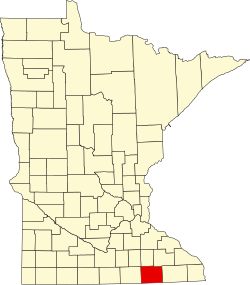
Lodi Township, Mower County, Minnesota

Last updated

Lodi Township, Minnesota
USA Minnesota location map.svg
Red pog.svg
Lodi Township, Minnesota
Location within the state of Minnesota
Usa edcp location map.svg
Red pog.svg
Lodi Township, Minnesota
Lodi Township, Minnesota (the United States)
Coordinates: 43°33′2″N92°36′59″W / 43.55056°N 92.61639°W / 43.55056; -92.61639
Country United States
State Minnesota
County Mower
Area
  Total35.6 sq mi (92.3 km2)
  Land35.6 sq mi (92.3 km2)
  Water0.0 sq mi (0.0 km2)
Elevation
1,348 ft (411 m)
Population
 (2000)
  Total249
  Density7.0/sq mi (2.7/km2)
Time zone UTC-6 (Central (CST))
  Summer (DST) UTC-5 (CDT)
FIPS code 27-37808 [1]
GNIS feature ID0664810 [2]

Lodi Township is a township in Mower County, Minnesota, in the United States. As of the 2000 census, the township population was 249. The largest town contained within the township is Taopi with 93 people. The remainder of the township is unincorporated area.

Contents

History

Almond Fryer settled on the banks of the Upper Iowa River in section 14 of the township in 1855. The name at the time of surveying was Lodi, but when the township was organized in February 1874 it was called "Belleview," as was the railroad station. Lodi, Italy, the namesake of the township, is a town in Lombardy made famous by a battle that Napoleon fought there. [3] At the organizing meeting, the people of the township re-adopted the name Lodi and elected a moderator, a clerk, three judges of the election, a chairman, two supervisors, a treasurer, two justices of the peace, and two constables. The current village of Taopi was started as a corporation in 1875.

Geography

According to the United States Census Bureau, the township has a total area of 35.6 square miles (92.3 km2), all land.

Demographics

As of the census [1] of 2000, there were 249 people, 85 households, and 73 families residing in the township. The population density was 7.0 inhabitants per square mile (2.7/km2). There were 85 housing units at an average density of 2.4 per square mile (0.93/km2). The racial makeup of the township was 97.99% White, 1.20% African American, and 0.80% from two or more races. Hispanic or Latino of any race were 0.40% of the population.

There were 85 households, out of which 35.3% had children under the age of 18 living with them, 78.8% were married couples living together, 2.4% had a female householder with no husband present, and 14.1% were non-families. 14.1% of all households were made up of individuals, and 4.7% had someone living alone who was 65 years of age or older. The average household size was 2.93 and the average family size was 3.19.

In the township the population was spread out, with 29.7% under the age of 18, 7.2% from 18 to 24, 27.3% from 25 to 44, 20.9% from 45 to 64, and 14.9% who were 65 years of age or older. The median age was 38 years. For every 100 females, there were 114.7 males. For every 100 females age 18 and over, there were 110.8 males.

The median income for a household in the township was $45,179, and the median income for a family was $45,714. Males had a median income of $28,125 versus $21,771 for females. The per capita income for the township was $17,504. About 11.8% of families and 12.3% of the population were below the poverty line, including 14.1% of those under the age of eighteen and 13.9% of those 65 or over.

Cemetery

Related Research Articles

Morrison Township is a township in Aitkin County, Minnesota, United States. The population was 200 as of the 2010 census.

<span class="mw-page-title-main">Crooked Lake Township, Cass County, Minnesota</span> Township in Minnesota, United States

Crooked Lake Township is a township in Cass County, Minnesota, United States. The population was 498 as of the 2000 census. It is named after Roosevelt Lake, formerly known as Crooked Lake, a large lake located in this township. Crooked Lake is a translation from the Ojibwe Wewaagigamaag-zaaga'igan.

Burbank Township is a township in Kandiyohi County, Minnesota, United States. The population was 510 at the 2000 census.

<span class="mw-page-title-main">Adams, Minnesota</span> City in Minnesota, United States

Adams is a city in Adams Township, Mower County, Minnesota, United States. The population was 683 at the 2020 census, down from 787 in 2010.

Bennington Township is a township in Mower County, Minnesota, United States. The population was 178 at the 2000 census. All areas and population centers of the township are unincorporated areas. It was named for Bennington, Vermont, the site of a battle in the American Revolutionary War.

<span class="mw-page-title-main">Dexter, Minnesota</span> City in Minnesota, United States

Dexter is a city Mower County, Minnesota, United States. The population was 324 at the 2020 census.

Lansing Township is a township in Mower County, Minnesota, United States. The population was 1,292 at the 2000 census. The largest city contained partially within the township is Austin with 23,314 people. The southern part of Austin is in Austin Township. Lansing Township also contains the town of Mapleview and the unincorporated areas of Ramsey, Corning, and Lansing.

<span class="mw-page-title-main">Le Roy, Minnesota</span> City in Minnesota, United States

Le Roy is a city in Mower County, Minnesota, United States, surrounded by Le Roy Township. The population was 957 at the 2020 census. Lake Louise State Park is just outside the town.

<span class="mw-page-title-main">Racine, Minnesota</span> City in Minnesota, United States

Racine is a city in Mower County, Minnesota, United States. The population was 458 at the 2020 census.

Racine Township is a township in Mower County, Minnesota, United States. The population was 445 at the time of the 2000 census. The largest town in the township is Racine with a population of 442 as of the 2010 census.. All other area in the township is unincorporated.

<span class="mw-page-title-main">Rose Creek, Minnesota</span> City in Minnesota, United States

Rose Creek is a city in Mower County, Minnesota, United States. The population was 397 at the 2020 census.

<span class="mw-page-title-main">Sargeant, Minnesota</span> City in Minnesota, United States

Sargeant is a city in Mower County, Minnesota, United States. The population was 63 at the 2020 census.

Sargeant Township is a township in Mower County, Minnesota, United States. The population was 316 at the 2000 census. The largest town in the township is Sargeant with a population of 76 people. All other area in the township is unincorporated.

<span class="mw-page-title-main">Taopi, Minnesota</span> City in Minnesota, United States

Taopi is a city in Mower County, Minnesota, United States. The population was 61 at the 2020 census. It is located near the source of the Wapsipinicon River.

Waltham Township is a township in Mower County, Minnesota, United States. The population was 416 at the 2000 census. The largest town in the township is Waltham with a population of 196 people. All other area in the township is unincorporated.

Windom Township is a township in Mower County, Minnesota, United States. The population was 640 at the 2000 census. The largest town in the township is Rose Creek with a population of 354 people. All other area in the township is unincorporated. After unsuccessfully trying two names, the township was named in honor of Senator William Windom of Winona.

Anthony Township is a township in Norman County, Minnesota. As of the 2000 census, the population was 85.

<span class="mw-page-title-main">Elkton, Minnesota</span> City in Minnesota, United States

Elkton is a city in Marshall Township, Mower County, Minnesota, United States. The population was 130 at the 2020 census.

Cameron Township is a township in Murray County, Minnesota, United States. The population was 151 at the 2000 census.

<span class="mw-page-title-main">Enstrom Township, Roseau County, Minnesota</span> Township in Minnesota, United States

Enstrom Township is a township in Roseau County, Minnesota, United States. The population was 580 at the 2000 census.

References

  1. 1 2 "U.S. Census website". United States Census Bureau . Retrieved January 31, 2008.
  2. "US Board on Geographic Names". United States Geological Survey. October 25, 2007. Retrieved January 31, 2008.
  3. Upham, Warren (1920). Minnesota Geographic Names: Their Origin and Historic Significance. Minnesota Historical Society. p.  361.

Further reading