Dexter, Minnesota

Last updated

Dexter, Minnesota
City
Mower County Minnesota Incorporated and Unincorporated areas Dexter Highlighted.svg
Location in Mower County and the state of Minnesota
Coordinates: 43°43′10″N92°42′06″W / 43.71944°N 92.70167°W / 43.71944; -92.70167
Country United States
State Minnesota
County Mower
Area
[1]
  Total1.41 sq mi (3.65 km2)
  Land1.41 sq mi (3.65 km2)
  Water0.00 sq mi (0.00 km2)
Elevation
[2]
1,411 ft (430 m)
Population
 (2020) [3]
  Total324
  Density230.11/sq mi (88.83/km2)
Time zone UTC-6 (Central (CST))
  Summer (DST) UTC-5 (CDT)
ZIP code
55926
Area code 507
FIPS code 27-15886 [4]
GNIS feature ID2394528 [2]
Website dextermn.com
Windmill Truckstop on Interstate 90,
a former landmark of Dexter WindmillDexterMN2006-05-20.JPG
Windmill Truckstop on Interstate 90,
a former landmark of Dexter

Dexter is a city Mower County, Minnesota, United States. The population was 324 at the 2020 census. [3]

Contents

History

Dexter was platted in 1874 and named for Dexter Parrit, an early settler. [5] A post office has been in operation at Dexter since 1874. [6] Dexter was incorporated in 1878. [5]

Geography

Dexter is in central Mower County, 15 miles (24 km) east of Austin, the county seat, and 27 miles (43 km) southwest of Rochester. It is bordered to the north, west, and south by Dexter Township and to the east by Grand Meadow Township. It is served by Interstate 90, State Highway 16 (MN 16), and Mower County Roads 2 and 7. I-90 leads west to Austin and northeast 16 miles (26 km) to Stewartville, while MN 16 leads east 16 miles (26 km) to Spring Valley.

According to the U.S. Census Bureau, Dexter has a total area of 1.41 square miles (3.65 km2), all land. [1] The city sits on high ground that drains north toward the North Branch of the Root River; east toward the South Fork of Bear Creek, part of the Root River watershed; and southwest toward Rose Creek, part of the Cedar River watershed.

Demographics

Historical population
CensusPop.Note
1880 168
1890 150−10.7%
1900 27885.3%
1910 2811.1%
1920 2986.0%
1930 242−18.8%
1940 30325.2%
1950 3164.3%
1960 313−0.9%
1970 252−19.5%
1980 27910.7%
1990 3038.6%
2000 3339.9%
2010 3412.4%
2020 324−5.0%
U.S. Decennial Census [7]

2010 census

As of the census [8] of 2010, there were 341 people, 144 households, and 100 families living in the city. The population density was 227.3 inhabitants per square mile (87.8/km2). There were 151 housing units at an average density of 100.7 per square mile (38.9/km2). The racial makeup of the city was 95.9% White, 0.6% African American, 0.9% Native American, 0.3% Asian, 0.3% from other races, and 2.1% from two or more races. Hispanic or Latino of any race were 1.8% of the population.

There were 144 households, of which 29.9% had children under the age of 18 living with them, 52.1% were married couples living together, 11.8% had a female householder with no husband present, 5.6% had a male householder with no wife present, and 30.6% were non-families. 26.4% of all households were made up of individuals, and 12.5% had someone living alone who was 65 years of age or older. The average household size was 2.37 and the average family size was 2.78.

The median age in the city was 41.2 years. 21.4% of residents were under the age of 18; 8.3% were between the ages of 18 and 24; 25.3% were from 25 to 44; 29.4% were from 45 to 64; and 15.8% were 65 years of age or older. The gender makeup of the city was 50.1% male and 49.9% female.

2000 census

As of the census [4] of 2000, there were 333 people, 130 households, and 89 families living in the city. The population density was 229.8 inhabitants per square mile (88.7/km2). There were 133 housing units at an average density of 91.8 per square mile (35.4/km2). The racial makeup of the city was 97.30% White, 0.60% Native American, 0.30% Asian, 1.20% from other races, and 0.60% from two or more races. Hispanic or Latino of any race were 1.80% of the population.

There were 130 households, out of which 37.7% had children under the age of 18 living with them, 57.7% were married couples living together, 7.7% had a female householder with no husband present, and 31.5% were non-families. 30.0% of all households were made up of individuals, and 11.5% had someone living alone who was 65 years of age or older. The average household size was 2.56 and the average family size was 3.20.In the city, the population was spread out, with 29.7% under the age of 18, 6.6% from 18 to 24, 29.4% from 25 to 44, 22.8% from 45 to 64, and 11.4% who were 65 years of age or older. The median age was 36 years. For every 100 females, there were 88.1 males. For every 100 females age 18 and over, there were 87.2 males.

The median income for a household in the city was $31,875, and the median income for a family was $41,250. Males had a median income of $29,861 versus $23,750 for females. The per capita income for the city was $14,199. About 7.1% of families and 10.4% of the population were below the poverty line, including 11.7% of those under age 18 and 13.2% of those age 65 or over.

Related Research Articles

<span class="mw-page-title-main">Hallock, Minnesota</span> City in Minnesota, United States

Hallock is a city in and the county seat of Kittson County, Minnesota, United States. The population was 906 at the 2020 census.

<span class="mw-page-title-main">Adams, Minnesota</span> City in Minnesota, United States

Adams is a city in Adams Township, Mower County, Minnesota, United States. The population was 683 at the 2020 census, down from 787 in 2010.

Bennington Township is a township in Mower County, Minnesota, United States. The population was 178 at the 2000 census. All areas and population centers of the township are unincorporated areas. It was named for Bennington, Vermont, the site of a battle in the American Revolutionary War.

<span class="mw-page-title-main">Brownsdale, Minnesota</span> City in Minnesota, United States

Brownsdale is a city in Mower County, Minnesota, United States. The population was 633 at the 2020 census.

Dexter Township is a township in Mower County, Minnesota, United States. The population was 289 at the 2000 census. The largest town in the township is Dexter with a population of 333 people. All other areas of the township are unincorporated areas. It is named for Dexter Parritt, an early settler.

<span class="mw-page-title-main">Grand Meadow, Minnesota</span> City in Minnesota, United States

Grand Meadow is a city in Mower County, Minnesota, United States. The city is on the boundary between Grand Meadow Township and Frankford Township, and it is politically independent of both townships. The population was 1,139 at the 2010 census.

Grand Meadow Township is a township in Mower County, Minnesota, United States. The population was 344 at the 2000 census. The city of Grand Meadow, lies on the eastern boundary of Grand Meadow. All other areas of the township are unincorporated areas. The township was named for the typical landscapes within its borders.

<span class="mw-page-title-main">Le Roy, Minnesota</span> City in Minnesota, United States

Le Roy is a city in Mower County, Minnesota, United States, surrounded by Le Roy Township. The population was 957 at the 2020 census. Lake Louise State Park is just outside the town.

<span class="mw-page-title-main">Lyle, Minnesota</span> City in Minnesota, United States

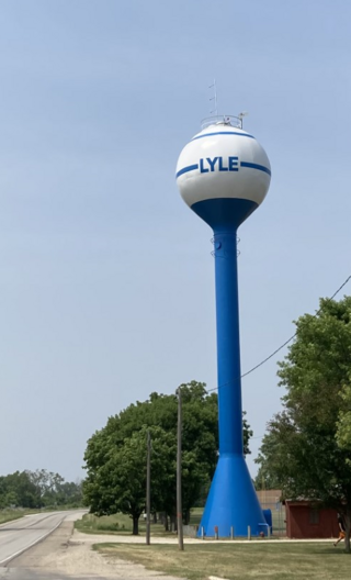
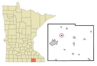
Lyle is a city in Mower County, Minnesota, United States. The city lies within a mile of the Iowa border, which also is its southern city limit. Lyle Township adjoins the city on its east, north, and west sides. The population was 551 at the 2010 census.

<span class="mw-page-title-main">Mapleview, Minnesota</span> City in Minnesota, United States

Mapleview is a city in Lansing Township, Mower County, Minnesota, United States. It is situated directly to the north of Austin's Oakwood Cemetery and can more or less be considered a suburb of Austin, although it is politically independent of it. The population was 176 at the 2010 census. It was named for a row of maple trees that once stood on the west side of town.

Nevada Township is a township in Mower County, Minnesota, United States. The population was 353 at the 2000 census. There are no recognized cities or towns and the township is entirely an unincorporated area.

<span class="mw-page-title-main">Racine, Minnesota</span> City in Minnesota, United States

Racine is a city in Racine Township, Mower County, Minnesota, United States. The population was 442 at the 2010 census.

<span class="mw-page-title-main">Rose Creek, Minnesota</span> City in Minnesota, United States

Rose Creek is a city in Windom Township, Mower County, Minnesota, United States. The population was 394 at the 2010 census.

<span class="mw-page-title-main">Sargeant, Minnesota</span> City in Minnesota, United States

Sargeant is a city in Sargeant Township, Mower County, Minnesota, United States. The population was 61 at the 2010 census.

<span class="mw-page-title-main">Taopi, Minnesota</span> City in Minnesota, United States

Taopi is a city in Lodi Township, Mower County, Minnesota, United States. The population was 58 at the 2010 census. It is located near the source of the Wapsipinicon River.

Udolpho Township is a township in Mower County, Minnesota, United States. The population was 458 at the 2000 census. There are no recognized cities or towns and the whole township is an unincorporated area. Blooming Prairie is only about a quarter of a mile away in Steele County to the north. The township's name is taken from a gothic novel titled The Mysteries of Udolpho by the English author Ann Radcliffe.

<span class="mw-page-title-main">Waltham, Minnesota</span> City in Minnesota, United States

Waltham is a city in Waltham Township, Mower County, Minnesota, United States. The population was 151 at the 2010 census.

<span class="mw-page-title-main">Elkton, Minnesota</span> City in Minnesota, United States

Elkton is a city in Marshall Township, Mower County, Minnesota, United States. The population was 130 at the 2020 census.

<span class="mw-page-title-main">Minnesota Lake, Minnesota</span> City in Minnesota, United States

Minnesota Lake is a city in Blue Earth and Faribault counties in the State of Minnesota. The population was 661 at the 2020 census. The bulk of the city is in Faribault County; a small part extends into Blue Earth County.

<span class="mw-page-title-main">Blooming Prairie, Minnesota</span> City in Minnesota, United States

Blooming Prairie is a city in Dodge and Steele counties in the U.S. state of Minnesota. The population was 1,996 at the 2010 census. Most of the city is located within Steele County; only a small part of the city extends into Dodge County.

References

  1. 1 2 "2023 U.S. Gazetteer Files: Minnesota". United States Census Bureau. Retrieved February 8, 2024.
  2. 1 2 U.S. Geological Survey Geographic Names Information System: Dexter, Minnesota
  3. 1 2 "P1. Race – Dexter city, Minnesota: 2020 DEC Redistricting Data (PL 94-171)". U.S. Census Bureau. Retrieved February 8, 2024.
  4. 1 2 "U.S. Census website". United States Census Bureau . Retrieved January 31, 2008.
  5. 1 2 Upham, Warren (1920). Minnesota Geographic Names: Their Origin and Historic Significance. Minnesota Historical Society. p. 360.
  6. "Mower County". Jim Forte Postal History. Retrieved July 22, 2015.
  7. "Census of Population and Housing". Census.gov. Retrieved June 4, 2015.
  8. "U.S. Census website". United States Census Bureau . Retrieved November 13, 2012.

Further reading


43°43′08″N92°42′17″W / 43.71889°N 92.70472°W / 43.71889; -92.70472