Waltham, Minnesota

Last updated

Waltham, Minnesota
Mower County Minnesota Incorporated and Unincorporated areas Waltham Highlighted.svg
Location in Mower County and the state of Minnesota
Coordinates: 43°49′10″N92°52′32″W / 43.81944°N 92.87556°W / 43.81944; -92.87556
Country United States
State Minnesota
County Mower
Area
[1]
  Total0.48 sq mi (1.24 km2)
  Land0.48 sq mi (1.24 km2)
  Water0.00 sq mi (0.00 km2)
Elevation
[2]
1,319 ft (402 m)
Population
 (2020) [3]
  Total164
  Density343.10/sq mi (132.48/km2)
Time zone UTC-6 (Central (CST))
  Summer (DST) UTC-5 (CDT)
ZIP code
55982
Area code 507
FIPS code 27-67918 [4]
GNIS feature ID2397185 [2]

Waltham is a city in Mower County, Minnesota, United States. The population was 164 at the 2020 census. [3]

Contents

History

Waltham was platted in 1885 and named after Waltham, Massachusetts. [5]

Geography

The community is in northwestern Mower County, surrounded by Waltham and independent of it. Minnesota State Highway 56 runs along the eastern border of the city, leading north 5 miles (8 km) to Hayfield and south the same distance to Brownsdale. Austin, the Mower county seat, is 15 miles (24 km) to the southwest via MN 56 and Interstate 90.

According to the U.S. Census Bureau, Waltham has a total area of 0.48 square miles (1.24 km2), all land. [1] It drains westward toward the Cedar River, a south-flowing tributary of the Iowa River.

Demographics

Historical population
CensusPop.Note
1900 150
1910 17013.3%
1920 1805.9%
1930 1905.6%
1940 172−9.5%
1950 21223.3%
1960 207−2.4%
1970 189−8.7%
1980 176−6.9%
1990 170−3.4%
2000 19615.3%
2010 151−23.0%
2020 1648.6%
U.S. Decennial Census [6]

2010 census

As of the census [7] of 2010, there were 151 people, 67 households, and 40 families living in the city. The population density was 328.3 inhabitants per square mile (126.8/km2). There were 73 housing units at an average density of 158.7 per square mile (61.3/km2). The racial makeup of the city was 97.4% White, 0.7% Asian, and 2.0% from two or more races. Hispanic or Latino of any race were 2.0% of the population.

There were 67 households, of which 23.9% had children under the age of 18 living with them, 49.3% were married couples living together, 4.5% had a female householder with no husband present, 6.0% had a male householder with no wife present, and 40.3% were non-families. 31.3% of all households were made up of individuals, and 6% had someone living alone who was 65 years of age or older. The average household size was 2.25 and the average family size was 2.90.

The median age in the city was 41.2 years. 19.9% of residents were under the age of 18; 7.1% were between the ages of 18 and 24; 28.5% were from 25 to 44; 33.1% were from 45 to 64; and 11.3% were 65 years of age or older. The gender makeup of the city was 54.3% male and 45.7% female.

2000 census

As of the census [4] of 2000, there were 196 people, 68 households, and 52 families living in the city. The population density was 425.0 inhabitants per square mile (164.1/km2). There were 72 housing units at an average density of 156.1 per square mile (60.3/km2). The racial makeup of the city was 96.43% White, 3.57% from other races. Hispanic or Latino of any race were 6.63% of the population.

There were 68 households, out of which 39.7% had children under the age of 18 living with them, 61.8% were married couples living together, 8.8% had a female householder with no husband present, and 23.5% were non-families. 20.6% of all households were made up of individuals, and 8.8% had someone living alone who was 65 years of age or older. The average household size was 2.88 and the average family size was 3.31.

In the city, the population was spread out, with 32.1% under the age of 18, 9.7% from 18 to 24, 27.6% from 25 to 44, 16.3% from 45 to 64, and 14.3% who were 65 years of age or older. The median age was 35 years. For every 100 females, there were 98.0 males. For every 100 females age 18 and over, there were 98.5 males.

The median income for a household in the city was $35,000, and the median income for a family was $35,625. Males had a median income of $27,500 versus $21,042 for females. The per capita income for the city was $26,047. About 4.1% of families and 5.2% of the population were below the poverty line, including 8.3% of those under the age of eighteen and none of those 65 or over.

Related Research Articles

<span class="mw-page-title-main">Tyro, Kansas</span> City in Montgomery County, Kansas

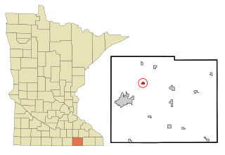
Tyro is a city in Montgomery County, Kansas, United States. As of the 2020 census, the population of the city was 177.

<span class="mw-page-title-main">Adams, Minnesota</span> City in Minnesota, United States

Adams is a city in Adams Township, Mower County, Minnesota, United States. The population was 683 at the 2020 census, down from 787 in 2010.

Adams Township is a township in Mower County, Minnesota, United States. The population was 475 at the 2000 census. The largest town in the township is Adams with a population of 800 people.

<span class="mw-page-title-main">Brownsdale, Minnesota</span> City in Minnesota, United States

Brownsdale is a city in Mower County, Minnesota, United States. The population was 633 at the 2020 census.

<span class="mw-page-title-main">Dexter, Minnesota</span> City in Minnesota, United States

Dexter is a city Mower County, Minnesota, United States. The population was 324 at the 2020 census.

Dexter Township is a township in Mower County, Minnesota, United States. The population was 289 at the 2000 census. The largest town in the township is Dexter with a population of 333 people. All other areas of the township are unincorporated areas. It is named for Dexter Parritt, an early settler.

<span class="mw-page-title-main">Grand Meadow, Minnesota</span> City in Minnesota, United States

Grand Meadow is a city in Mower County, Minnesota, United States. The city is on the boundary between Grand Meadow Township and Frankford Township, and it is politically independent of both townships. The population was 1,127 at the 2020 census.

Grand Meadow Township is a township in Mower County, Minnesota, United States. The population was 344 at the 2000 census. The city of Grand Meadow, lies on the eastern boundary of Grand Meadow. All other areas of the township are unincorporated areas. The township was named for the typical landscapes within its borders.

<span class="mw-page-title-main">Le Roy, Minnesota</span> City in Minnesota, United States

Le Roy is a city in Mower County, Minnesota, United States, surrounded by Le Roy Township. The population was 957 at the 2020 census. Lake Louise State Park is just outside the town.

<span class="mw-page-title-main">Lyle, Minnesota</span> City in Minnesota, United States

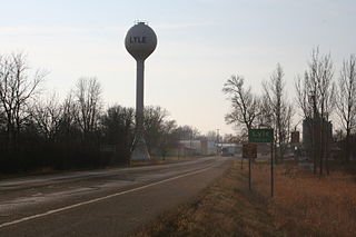
Lyle is a city in Mower County, Minnesota, United States. The city lies on the north side of the Iowa border. The population was 522 at the 2020 census.

<span class="mw-page-title-main">Mapleview, Minnesota</span> City in Minnesota, United States

Mapleview is a city in Lansing Township, Mower County, Minnesota, United States. It is a suburb of Austin, the county seat. The population was 144 at the 2020 census, down from 176 in 2010. It was named for a row of maple trees that once stood on the west side of town.

Pleasant Valley Township is a township in Mower County, Minnesota, United States. The population was 308 at the 2000 census. There are no recognized cities or towns and the township is entirely an unincorporated area.

<span class="mw-page-title-main">Racine, Minnesota</span> City in Minnesota, United States

Racine is a city in Mower County, Minnesota, United States. The population was 458 at the 2020 census.

<span class="mw-page-title-main">Rose Creek, Minnesota</span> City in Minnesota, United States

Rose Creek is a city in Mower County, Minnesota, United States. The population was 397 at the 2020 census.

<span class="mw-page-title-main">Sargeant, Minnesota</span> City in Minnesota, United States

Sargeant is a city in Mower County, Minnesota, United States. The population was 63 at the 2020 census.

<span class="mw-page-title-main">Taopi, Minnesota</span> City in Minnesota, United States

Taopi is a city in Mower County, Minnesota, United States. The population was 61 at the 2020 census. It is located near the source of the Wapsipinicon River.

Waltham Township is a township in Mower County, Minnesota, United States. The population was 416 at the 2000 census. The largest town in the township is Waltham with a population of 196 people. All other area in the township is unincorporated.

<span class="mw-page-title-main">Elkton, Minnesota</span> City in Minnesota, United States

Elkton is a city in Marshall Township, Mower County, Minnesota, United States. The population was 130 at the 2020 census.

<span class="mw-page-title-main">Old River-Winfree, Texas</span> City in Texas, United States

Old River-Winfree is a city in Chambers and Liberty counties, Texas, United States. The population was 1,315 at the 2020 census.

<span class="mw-page-title-main">Blooming Prairie, Minnesota</span> City in Minnesota, United States

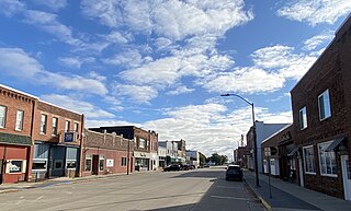
Blooming Prairie is a city in Dodge and Steele counties in the U.S. state of Minnesota. The population was 1,996 at the 2010 census. Most of the city is located within Steele County; only a small part of the city extends into Dodge County.

References

  1. 1 2 "2023 U.S. Gazetteer Files: Minnesota". United States Census Bureau. Retrieved February 12, 2024.
  2. 1 2 U.S. Geological Survey Geographic Names Information System: Waltham, Minnesota
  3. 1 2 "P1. Race – Waltham city, Minnesota: 2020 DEC Redistricting Data (PL 94-171)". U.S. Census Bureau. Retrieved February 12, 2024.
  4. 1 2 "U.S. Census website". United States Census Bureau . Retrieved January 31, 2008.
  5. Upham, Warren (1920). Minnesota Geographic Names: Their Origin and Historic Significance. Minnesota Historical Society. p.  362.
  6. "Census of Population and Housing". Census.gov. Retrieved June 4, 2015.
  7. "U.S. Census website". United States Census Bureau . Retrieved November 13, 2012.

Further reading

43°49′18″N92°52′38″W / 43.82167°N 92.87722°W / 43.82167; -92.87722