Long Creek, North Dakota | |
|---|---|
 Long Creek  Long Creek | |
| Coordinates: 48°06′06″N103°15′31″W / 48.10167°N 103.25861°W | |
| Country | United States |
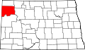
| State | North Dakota |
| County | Williams |
| Township | Truax |
| Area | |
• Total | 0.24 sq mi (0.61 km2) |
| • Land | 0.24 sq mi (0.61 km2) |
| • Water | 0 sq mi (0.00 km2) |
| Elevation | 1,942 ft (592 m) |
| Population (2020) | |
• Total | 104 |
| • Density | 441.3/sq mi (170.37/km2) |
| Time zone | UTC-6 (Central (CST)) |
| • Summer (DST) | UTC-5 (CDT) |
| ZIP Code | 58843 (Epping) |
| Area code | 701 |
| FIPS code | 38-47796 |
| GNIS feature ID | 2805289 [2] |
Long Creek is an unincorporated community and census-designated place (CDP) in Williams County, North Dakota, United States. It was first listed as a CDP prior to the 2020 census. [2]
Contents
The CDP is on the southern edge of Williams County, on the northern shore of Lake Sakakawea, a large reservoir on the Missouri River. The community sits between two inlets to the lake: Long Creek to the north and Chris Creek to the south. Lewis and Clark State Park is to the north, across Long Creek. The CDP is bordered to the west by 119th Road NW. Williston is 22 miles (35 km) to the northwest by road.