Grenora, North Dakota

Last updated

Grenora, North Dakota
Grenora, North Dakota.jpg
ND Williams County Grenora.svg
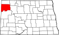
Location of Grenora, North Dakota
Coordinates: 48°37′12″N103°56′12″W / 48.62000°N 103.93667°W / 48.62000; -103.93667
CountryUnited States
State North Dakota
County Williams
FoundedJuly 1916
Government
   Mayor Brett Wilkins
Area
[1]
  Total0.61 sq mi (1.57 km2)
  Land0.61 sq mi (1.57 km2)
  Water0.00 sq mi (0.00 km2)
Elevation
[2]
2,133 ft (650 m)
Population
 (2020) [3]
  Total221
  Estimate 
(2022) [4]
209
  Density363.49/sq mi (140.44/km2)
Time zone UTC-6 (Central (CST))
  Summer (DST) UTC-5 (CDT)
ZIP code
58845
Area code 701
FIPS code 38-33500
GNIS feature ID1036069 [2]
Website cityofgrenora.com

Grenora is a city in Williams County, North Dakota, United States. The population was 221 at the 2020 census. [3]

Contents

Grenora was founded in July 1916 at the terminus of a Great Northern Railway branch line that began in Stanley. The name is a portmanteau of letters in the railway's name: GREat NOrthern RAilway. [5] [6] The tracks were in place until 2002, when Great Northern successor BNSF Railway filed for abandonment. [7]

The city's motto is, "Friendliness lives here – you're only a stranger once." The city is home to a senior citizen's center, credit union, gas station, grain elevator, restaurant, bar, apartment buildings, and community built low-income housing. There are also two churches: the St. Olaf Lutheran Church (ELCA) and St. Boniface Catholic Church.

Demographics

Historical population
CensusPop.Note
1920 358
1930 48736.0%
1940 425−12.7%
1950 52523.5%
1960 448−14.7%
1970 401−10.5%
1980 362−9.7%
1990 261−27.9%
2000 202−22.6%
2010 24420.8%
2020 221−9.4%
2022 (est.)209 [4] −5.4%
U.S. Decennial Census [8]
2020 Census [3]

2010 census

As of the census of 2010, there were 244 people, 98 households, and 65 families residing in the city. The population density was 400.0 inhabitants per square mile (154.4/km2). There were 121 housing units at an average density of 198.4 per square mile (76.6/km2). The racial makeup of the city was 97.5% White, 0.4% African American, 0.8% Native American, and 1.2% from two or more races. Hispanic or Latino of any race were 4.5% of the population.

There were 98 households, of which 30.6% had children under the age of 18 living with them, 52.0% were married couples living together, 9.2% had a female householder with no husband present, 5.1% had a male householder with no wife present, and 33.7% were non-families. 29.6% of all households were made up of individuals, and 13.3% had someone living alone who was 65 years of age or older. The average household size was 2.49 and the average family size was 3.09.

The median age in the city was 36.3 years. 30.3% of residents were under the age of 18; 3.7% were between the ages of 18 and 24; 26.3% were from 25 to 44; 25.8% were from 45 to 64; and 13.9% were 65 years of age or older. The gender makeup of the city was 48.0% male and 52.0% female.

2000 census

As of the census of 2000, there were 202 people, 98 households, and 58 families residing in the city. The population density was 342.7 inhabitants per square mile (132.3/km2). There were 139 housing units at an average density of 235.8 per square mile (91.0/km2). The racial makeup of the city was 98.02% White, 0.99% Native American, and 0.99% from two or more races.

There were 98 households, out of which 17.3% had children under the age of 18 living with them, 55.1% were married couples living together, 3.1% had a female householder with no husband present, and 39.8% were non-families. 39.8% of all households were made up of individuals, and 23.5% had someone living alone who was 65 years of age or older. The average household size was 2.06 and the average family size was 2.76.

In the city, the population was spread out, with 18.3% under the age of 18, 5.0% from 18 to 24, 23.3% from 25 to 44, 24.3% from 45 to 64, and 29.2% who were 65 years of age or older. The median age was 48 years. For every 100 females, there were 124.4 males. For every 100 females age 18 and over, there were 126.0 males.

The median income for a household in the city was $26,250, and the median income for a family was $37,083. Males had a median income of $31,750 versus $15,625 for females. The per capita income for the city was $13,960. None of the families and 4.2% of the population were living below the poverty line, including no under eighteens and 9.6% of those over 64.

Geography

Climate

This climatic region is typified by large seasonal temperature differences, with warm to hot (and often humid) summers and cold (sometimes severely cold) winters. According to the Köppen Climate Classification system, Grenora has a humid continental climate, abbreviated "Dfb" on climate maps. [9]

Related Research Articles

<span class="mw-page-title-main">Lansford, North Dakota</span> City in North Dakota, United States

Lansford is a city in Bottineau County, North Dakota, United States. The population was 238 at the 2020 census. Lansford was founded in 1903.

<span class="mw-page-title-main">Mapleton, North Dakota</span> City in North Dakota, United States

Mapleton is a city in Cass County, North Dakota, United States. It sits on the banks of the Maple River. The population was 1,320 at the 2020 census. Mapleton serves as a bedroom community of the Fargo-Moorhead metropolitan area. The core cities are ten miles to the east of Mapleton.

<span class="mw-page-title-main">Ambrose, North Dakota</span> City in North Dakota, United States

Ambrose is a city in Divide County, North Dakota, United States. The population was 24 at the 2020 census. Ambrose was founded in 1906.

<span class="mw-page-title-main">Crosby, North Dakota</span> City in North Dakota

Crosby is a city and the county seat of Divide County, North Dakota, United States. The population was 1,065 at the 2020 census.

<span class="mw-page-title-main">Killdeer, North Dakota</span> City in North Dakota, United States

Killdeer is a city in Dunn County, North Dakota, United States. The population was 939 at the 2020 census.

<span class="mw-page-title-main">New Rockford, North Dakota</span> City in North Dakota, United States

New Rockford is a city in Eddy County, North Dakota, United States. It is the county seat of Eddy County. The population was 1,361 at the 2020 census. New Rockford was founded in 1883.

<span class="mw-page-title-main">McHenry, North Dakota</span> City in North Dakota, United States

McHenry is a city in Foster County, North Dakota, United States. The population was 64 at the 2020 census. McHenry was founded in 1899.

<span class="mw-page-title-main">Napoleon, North Dakota</span> City in North Dakota, United States

Napoleon is a city in Logan County, North Dakota, United States. It is the county seat of Logan County. The population was 749 at the 2020 census.

<span class="mw-page-title-main">Wishek, North Dakota</span> City in North Dakota, United States

Wishek is a city in McIntosh County, North Dakota, United States. The population was 864 at the 2020 census.

<span class="mw-page-title-main">Taylor, North Dakota</span> City in North Dakota, United States

Taylor is a city in Stark County, North Dakota, United States. The population was 230 at the 2020 census. It is part of the Dickinson Micropolitan Statistical Area.

<span class="mw-page-title-main">Pingree, North Dakota</span> City in North Dakota, United States

Pingree is a city in Stutsman County, North Dakota, United States. The population was 41 at the 2020 census. Pingree was founded in 1882.

<span class="mw-page-title-main">Kenmare, North Dakota</span> City in North Dakota, United States

Kenmare is a city in Ward County, North Dakota, United States. The population was 961 at the 2020 census. Kenmare is part of the Minot Micropolitan Statistical Area.

<span class="mw-page-title-main">Surrey, North Dakota</span> City in North Dakota, United States

Surrey is a town in Ward County, North Dakota, United States. The population was 1,357 at the 2020 census. Official incorporation of Surrey occurred in 1951. The city is part of the Minot Micropolitan Statistical Area.

<span class="mw-page-title-main">Harvey, North Dakota</span> City in North Dakota, United States

Harvey is a city in Wells County, North Dakota, United States. The population was 1,650 at the 2020 census. Harvey was founded in 1893 as a division point by the Soo Line Railway. Harvey is believed to have been named for a director of the Soo Line Railway, Col. Scott William Harvey of Minneapolis, Minnesota.

<span class="mw-page-title-main">Epping, North Dakota</span> City in North Dakota, United States

Epping is a city in Williams County, North Dakota, United States. The population was 84 at the 2020 census.

<span class="mw-page-title-main">Columbia, South Dakota</span> City in South Dakota, United States

Columbia is an incorporated small town on the James River in Brown County, South Dakota, United States. The population was 160 at the 2020 census. There is a large granary co-op at Columbia, also a post office, a bank, a bar, a church, a town park, and a community center, in addition to the city hall; and many homes.

<span class="mw-page-title-main">Miller, South Dakota</span> City in South Dakota, United States

Miller is a city in and county seat of Hand County, South Dakota, United States. The population was 1,349 at the 2020 census.

<span class="mw-page-title-main">Menno, South Dakota</span> City in South Dakota, United States

Menno is a city in Hutchinson County, South Dakota, United States. The population was 614 at the 2020 census.

<span class="mw-page-title-main">Montrose, South Dakota</span> City in South Dakota, United States

Montrose is a city in McCook County, South Dakota, United States. The population was 468 at the 2020 census.

<span class="mw-page-title-main">Carthage, South Dakota</span> City in South Dakota, United States

Carthage is a city in Miner County, South Dakota, United States. The population was 127 at the 2020 census.

References

  1. "ArcGIS REST Services Directory". United States Census Bureau. Retrieved September 20, 2022.
  2. 1 2 U.S. Geological Survey Geographic Names Information System: Grenora, North Dakota
  3. 1 2 3 "Explore Census Data". United States Census Bureau . Retrieved November 12, 2023.
  4. 1 2 "City and Town Population Totals: 2020-2022". United States Census Bureau. November 12, 2023. Retrieved November 12, 2023.
  5. Wick, Douglas A. "Grenora (Williams County)". North Dakota Place Names. Retrieved May 8, 2011.
  6. Temple, Robert D. Edge Effects: The Border-Name Places, (2nd edition, 2009), iUniverse, ISBN   978-0-595-47758-6, page 324.
  7. "THE BURLINGTON NORTHERN AND SANTA FE RAILWAY COMPANY--ABANDONMENT EXEMPTION--IN BURKE AND WILLIAMS COUNTIES, ND". Docket Number AB_6_394_X. Surface Transportation Board . Retrieved May 8, 2011.
  8. "U.S. Decennial Census". Census.gov. Retrieved May 25, 2014.
  9. Climate Summary for Grenora, North Dakota