Zahl, North Dakota

Last updated

Zahl
Zahl ND.jpg
Zahl, North Dakota
USA North Dakota location map.svg
Red pog.svg
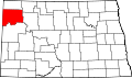
Zahl
Location within the state of North Dakota
Usa edcp location map.svg
Red pog.svg
Zahl
Zahl (the United States)
Coordinates: 48°34′24″N103°41′32″W / 48.57333°N 103.69222°W / 48.57333; -103.69222
Country United States
State North Dakota
County Williams
Elevation
[1]
2,015 ft (614 m)
Time zone UTC-6 (Central (CST))
  Summer (DST) UTC-5 (CDT)
ZIP codes
58856
Area code 701
GNIS feature ID1032901 [1]

Zahl is an unincorporated community in northwestern Williams County, North Dakota, United States. It lies along North Dakota Highway 50 north of the city of Williston, the county seat of Williams County. [2]

Contents

History

A post office called Zahl has been in operation since 1905. [3] The community bears the name of F. R. Zahl, an early settler. [4]

Climate

This climatic region is typified by large seasonal temperature differences, with warm to hot (and often humid) summers and cold (sometimes severely cold) winters. According to the Köppen Climate Classification system, Zahl has a humid continental climate, abbreviated "Dfb" on climate maps. [5]

References

  1. 1 2 U.S. Geological Survey Geographic Names Information System: Zahl, North Dakota
  2. Rand McNally. The Road Atlas '08. Chicago: Rand McNally, 2008, p. 77.
  3. "Williams County". Jim Forte Postal History. Retrieved October 25, 2015.
  4. Federal Writers' Project (1938). North Dakota, a Guide to the Northern Prairie State. WPA. p. 219. ISBN   978-1-62376-033-5.{{cite book}}: ISBN / Date incompatibility (help)
  5. Climate Summary for Zahl, North Dakota