Alamo, North Dakota

Last updated

Alamo, North Dakota
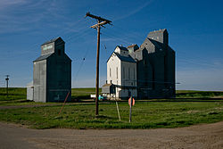
Alamo, North Dakota.jpg
The grain elevators in Alamo
ND Williams County Alamo.svg
Location of Alamo, North Dakota
Coordinates: 48°34′48″N103°28′10″W / 48.58000°N 103.46944°W / 48.58000; -103.46944
CountryUnited States
State North Dakota
County Williams
Founded1916
Area
[1]
  Total0.57 sq mi (1.48 km2)
  Land0.55 sq mi (1.42 km2)
  Water0.02 sq mi (0.06 km2)
Elevation
2,123 ft (647 m)
Population
 (2020)
  Total53
  Density96.72/sq mi (37.31/km2)
Time zone UTC-6 (CST)
  Summer (DST) UTC-5 (CDT)
ZIP code
58830
Area code 701
FIPS code 38-00940
GNIS feature ID1027663 [2]

Alamo is a city in Williams County, North Dakota, United States. The population was 57 at the 2010 census. [3] Alamo was founded in 1916.

Contents

Geography

Alamo is located at 48°34′48″N103°28′10″W / 48.58000°N 103.46944°W / 48.58000; -103.46944 (48.580065, -103.469390). [4]

According to the United States Census Bureau, the city has a total area of 0.57 square miles (1.48 km2), of which 0.55 square miles (1.42 km2) is land and 0.02 square miles (0.05 km2) is water. [5]

Demographics

Historical population
CensusPop.Note
1930 211
1940 2141.4%
1950 192−10.3%
1960 182−5.2%
1970 124−31.9%
1980 122−1.6%
1990 69−43.4%
2000 51−26.1%
2010 5711.8%
2020 53−7.0%
2021 (est.)52 [6] −1.9%
U.S. Decennial Census [7]
2020 Census [3]

2010 census

As of the census of 2010, there were 57 people, 25 households, and 11 families residing in the city. The population density was 103.6 inhabitants per square mile (40.0/km2). There were 41 housing units at an average density of 74.5 per square mile (28.8/km2). The racial makeup of the city was 86.0% White, 12.3% from other races, and 1.8% from two or more races. Hispanic or Latino of any race were 12.3% of the population.

There were 25 households, of which 24.0% had children under the age of 18 living with them, 32.0% were married couples living together, 4.0% had a female householder with no husband present, 8.0% had a male householder with no wife present, and 56.0% were non-families. 36.0% of all households were made up of individuals, and 16% had someone living alone who was 65 years of age or older. The average household size was 2.28 and the average family size was 3.18.

The median age in the city was 39.4 years. 24.6% of residents were under the age of 18; 1.8% were between the ages of 18 and 24; 30% were from 25 to 44; 24.6% were from 45 to 64; and 19.3% were 65 years of age or older. The gender makeup of the city was 56.1% male and 43.9% female.

2000 census

As of the census of 2000, there were 51 people, 25 households, and 18 families residing in the city. The population density was 94.0 inhabitants per square mile (36.3/km2). There were 43 housing units at an average density of 79.3 per square mile (30.6/km2). The racial makeup of the city was 100.00% White.

There were 25 households, out of which 16.0% had children under the age of 18 living with them, 64.0% were married couples living together, 8.0% had a female householder with no husband present, and 28.0% were non-families. 28.0% of all households were made up of individuals, and 4.0% had someone living alone who was 65 years of age or older. The average household size was 2.04 and the average family size was 2.44.

In the city, the population was spread out, with 9.8% under the age of 18, 5.9% from 18 to 24, 13.7% from 25 to 44, 41.2% from 45 to 64, and 29.4% who were 65 years of age or older. The median age was 50 years. For every 100 females, there were 121.7 males. For every 100 females age 18 and over, there were 109.1 males.

The median income for a household in the city was $27,917, and the median income for a family was $29,792. Males had a median income of $30,000 versus $11,667 for females. The per capita income for the city was $17,138. There were 5.9% of families and 10.4% of the population living below the poverty line, including 100.0% of under eighteens and 14.3% of those over 64.
Related Research Articles

<span class="mw-page-title-main">Alamo, Georgia</span> City in Georgia, United States

Alamo is a city in Wheeler County, Georgia, United States. As of the 2020 census, the city had a population of 771. The city is the county seat of Wheeler County.

<span class="mw-page-title-main">Forreston, Illinois</span> Village in Illinois, United States

Forreston is a village in Ogle County, Illinois, United States. The population was 1,446 at the 2010 census, down from 1,469 in 2000.

<span class="mw-page-title-main">Garber, Iowa</span> City in Iowa, United States

Garber is a city in Clayton County, Iowa, United States. The population was 76 at the time of the 2020 census, down from 103 in 2000.

<span class="mw-page-title-main">Soldier, Iowa</span> City in Iowa, United States

Soldier is a city in Monona County, Iowa, United States, along the Soldier River. The population was 184 at the time of the 2020 census.

<span class="mw-page-title-main">Earlton, Kansas</span> City in Neosho County, Kansas

Earlton is a city in Neosho County, Kansas, United States. As of the 2020 census, the population of the city was 60.

<span class="mw-page-title-main">Nickerson, Nebraska</span> Village in Nebraska, United States

Nickerson is a village in Dodge County, Nebraska, United States. The population was 369 at the 2010 census.

<span class="mw-page-title-main">Alamo, New Mexico</span> Census-designate place in Socorro County, New Mexico, United States

Alamo is a census-designated place (CDP) in Socorro County, New Mexico, United States. The population was 1,085 at the 2010 census. It is the largest community on the Alamo Navajo Indian Reservation.

<span class="mw-page-title-main">Bowman, North Dakota</span> City in North Dakota, United States

Bowman is a city and county seat of Bowman County, North Dakota, United States. The population was 1,470 at the 2020 census.

<span class="mw-page-title-main">Crosby, North Dakota</span> City in North Dakota

Crosby is a city and the county seat of Divide County, North Dakota, United States. The population was 1,065 at the 2020 census.

<span class="mw-page-title-main">Noonan, North Dakota</span> City in North Dakota, United States

Noonan is a city in Divide County, North Dakota, United States. The population was 137 at the 2020 census.

<span class="mw-page-title-main">Ray, North Dakota</span> City in North Dakota, United States

Ray is a city in Williams County, North Dakota, United States. The population was 740 at the 2020 census.

<span class="mw-page-title-main">Springbrook, North Dakota</span> City in North Dakota, United States

Springbrook is a city in Williams County, North Dakota, United States. The population was 37 at the 2020 census. It is also spelled Spring Brook.

<span class="mw-page-title-main">Wildrose, North Dakota</span> City in North Dakota, United States

Wildrose is a city in Williams County, North Dakota, United States. The population was 115 at the 2020 census. Wildrose was founded in 1910.

<span class="mw-page-title-main">Sarahsville, Ohio</span> Village in Ohio, United States

Sarahsville is a village in Noble County, Ohio, United States. The population was 147 at the 2020 census..

<span class="mw-page-title-main">Beach City, Ohio</span> Village in Ohio, United States

Beach City is a village in southwestern Stark County, Ohio, United States. The population was 940 at the 2020 census. It is part of the Canton–Massillon metropolitan area.

<span class="mw-page-title-main">Lumber City, Pennsylvania</span> Former Borough in Pennsylvania, United States

Lumber City is a former borough in Clearfield County, Pennsylvania, United States. The population was 76 at the 2010 census.

<span class="mw-page-title-main">Clio, South Carolina</span> Town in South Carolina, United States

Clio is a town in Marlboro County, South Carolina, United States. The population was 726 at the 2010 census. Marlboro School of Discovery is a magnet school in Clio, South Carolina and is part of the Marlboro County School District.

<span class="mw-page-title-main">Saluda, South Carolina</span> Town in South Carolina, United States

Saluda is a town in Saluda County, South Carolina, United States, along the Little Saluda River. The population was 3,565 at the 2010 census. It is the county seat of Saluda County.

<span class="mw-page-title-main">Leary, Texas</span> City in Texas, United States

Leary is a city in Bowie County, Texas, United States. As part of the Texarkana metropolitan area, it had a 2020 census population of 433, down from 495 in 2010.

<span class="mw-page-title-main">Trimbelle, Wisconsin</span> Town in Wisconsin, United States

Trimbelle is a town in Pierce County, Wisconsin, United States. The population was 1,511 at the 2000 census. The unincorporated communities of Beldenville and Ottman Corners are located in the town. The unincorporated community of Moeville is also located partially in the town.

References

  1. "ArcGIS REST Services Directory". United States Census Bureau. Retrieved September 20, 2022.
  2. "US Board on Geographic Names". United States Geological Survey. October 25, 2007. Retrieved January 31, 2008.
  3. 1 2 "Explore Census Data". United States Census Bureau . Retrieved July 16, 2022.
  4. "US Gazetteer files: 2010, 2000, and 1990". United States Census Bureau. February 12, 2011. Retrieved April 23, 2011.
  5. "US Gazetteer files 2010". United States Census Bureau. Archived from the original on January 12, 2012. Retrieved June 14, 2012.
  6. "City and Town Population Totals: 2020-2021". United States Census Bureau. July 16, 2022. Retrieved July 16, 2022.
  7. United States Census Bureau. "Census of Population and Housing" . Retrieved September 7, 2013.