Wildrose, North Dakota

Last updated
Wildrose, North Dakota
Cafe wildrose north dakota 2009.jpg
Cafe in Wildrose
ND Williams County Wildrose.svg
Location of Wildrose, North Dakota
Coordinates: 48°37′49″N103°11′0″W / 48.63028°N 103.18333°W / 48.63028; -103.18333 Coordinates: 48°37′49″N103°11′0″W / 48.63028°N 103.18333°W / 48.63028; -103.18333
CountryUnited States
State North Dakota
County Williams
Founded1910
Area
[1]
  Total0.29 sq mi (0.75 km2)
  Land0.29 sq mi (0.75 km2)
  Water0.00 sq mi (0.00 km2)
Elevation
2,251 ft (686 m)
Population
 (2020)
  Total115
  Density396.55/sq mi (152.88/km2)
Time zone UTC-6 (CST)
  Summer (DST) UTC-5 (CDT)
ZIP code
58795
Area code 701
FIPS code 38-86020
GNIS feature ID1032808 [2]

Wildrose is a city in Williams County, North Dakota, United States. The population was 115 at the 2020 census. [3] Wildrose was founded in 1910.

Contents

Geography

Wildrose is located at 48°37′49″N103°11′0″W / 48.63028°N 103.18333°W / 48.63028; -103.18333 (48.630318, -103.183464). [4]

According to the United States Census Bureau, the city has a total area of 0.29 square miles (0.75 km2), all land. [5]

Demographics

Historical population
CensusPop.
1920 449
1930 51815.4%
1940 472−8.9%
1950 430−8.9%
1960 361−16.0%
1970 235−34.9%
1980 214−8.9%
1990 193−9.8%
2000 129−33.2%
2010 110−14.7%
2020 1154.5%
2021 (est.)108 [6] −6.1%
U.S. Decennial Census [7]
2020 Census [3]

2010 census

As of the census of 2010, there were 110 people, 63 households, and 27 families residing in the city. The population density was 379.3 inhabitants per square mile (146.4/km2). There were 91 housing units at an average density of 313.8 per square mile (121.2/km2). The racial makeup of the city was 96.4% White, 2.7% Native American, and 0.9% from two or more races. Hispanic or Latino of any race were 4.5% of the population.

There were 63 households, of which 14.3% had children under the age of 18 living with them, 36.5% were married couples living together, 6.3% had a female householder with no husband present, and 57.1% were non-families. 47.6% of all households were made up of individuals, and 22.2% had someone living alone who was 65 years of age or older. The average household size was 1.75 and the average family size was 2.52.

The median age in the city was 52.6 years. 12.7% of residents were under the age of 18; 3.5% were between the ages of 18 and 24; 14.5% were from 25 to 44; 46.4% were from 45 to 64; and 22.7% were 65 years of age or older. The gender makeup of the city was 49.1% male and 50.9% female.

2000 census

As of the census of 2000, there were 129 people, 63 households, and 36 families residing in the city. The population density was 464.4 people per square mile (177.9/km2). There were 102 housing units at an average density of 367.2 per square mile (140.7/km2). The racial makeup of the city was 96.90% White and 3.10% Asian.

There were 63 households, out of which 19.0% had children under the age of 18 living with them, 44.4% were married couples living together, 14.3% had a female householder with no husband present, and 41.3% were non-families. 41.3% of all households were made up of individuals, and 15.9% had someone living alone who was 65 years of age or older. The average household size was 2.05 and the average family size was 2.76.

In the city, the population was spread out, with 22.5% under the age of 18, 4.7% from 18 to 24, 24.8% from 25 to 44, 22.5% from 45 to 64, and 25.6% who were 65 years of age or older. The median age was 43 years. For every 100 females, there were 101.6 males. For every 100 females age 18 and over, there were 104.1 males.

The median income for a household in the city was $19,167, and the median income for a family was $21,250. Males had a median income of $36,875 versus $17,250 for females. The per capita income for the city was $11,052. There were 19.4% of families and 13.5% of the population living below the poverty line, including 11.1% of under eighteens and 12.8% of those over 64.

Climate

This climatic region is typified by large seasonal temperature differences, with warm to hot (and often humid) summers and cold (sometimes severely cold) winters. According to the Köppen Climate Classification system, Wildrose has a humid continental climate, abbreviated "Dfb" on climate maps. [8]

Education

It is within the Nesson School District (Ray Public School). [9]

Related Research Articles

<span class="mw-page-title-main">New Milford, Illinois</span> Village in Illinois, United States

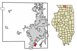
New Milford is a village in Winnebago County, Illinois, United States on the south bank of the Kishwaukee River overlooking the south side of Rockford. It is part of the Rockford, Illinois Metropolitan Statistical Area. The population was 697 at the 2010 census, up from 541 in 2000.

<span class="mw-page-title-main">Belleville, Kansas</span> City in Republic County, Kansas

Belleville is a city in and the county seat of Republic County, Kansas, United States. As of the 2020 census, the population of the city was 2,007.

<span class="mw-page-title-main">Beechwood Village, Kentucky</span> City in Kentucky, United States

Beechwood Village is a home rule-class city in Jefferson County, Kentucky, United States. The city was formally incorporated by the state assembly in 1950. The population was 1,324 at the 2010 census, up from 1,173 at the 2000 census.

<span class="mw-page-title-main">Dyer Brook, Maine</span> Town in Maine, United States

Dyer Brook is a town in Aroostook County, Maine, United States. The population was 215 at the 2020 census. Dyer Brook is also host to the local school, Southern Aroostook Community School.

<span class="mw-page-title-main">Smithfield, Maine</span> Town in Maine, United States

Smithfield is a town in Somerset County, Maine, United States. The population was 925 at the 2020 census. The town was incorporated on February 29, 1840 making it the only town in Maine incorporated on Leap Day. The town was named after the Rev. Henry Smith, an early settler.

<span class="mw-page-title-main">New Munich, Minnesota</span> City in Minnesota, United States

New Munich is a city in Stearns County, Minnesota, United States. The population was 320 at the 2010 census. It is part of the St. Cloud Metropolitan Statistical Area.

<span class="mw-page-title-main">Brinsmade, North Dakota</span> City in North Dakota, United States

For people with the surname, see Brinsmade (surname).

<span class="mw-page-title-main">Lansford, North Dakota</span> City in North Dakota, United States

Lansford is a city in Bottineau County, North Dakota, United States. The population was 238 at the 2020 census. Lansford was founded in 1903.

<span class="mw-page-title-main">Bowman, North Dakota</span> City in North Dakota, United States

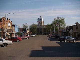
Bowman is a city and county seat of Bowman County, North Dakota, United States. The population was 1,470 at the 2020 census.

<span class="mw-page-title-main">Scranton, North Dakota</span> City in North Dakota, United States

Scranton is a small town in Bowman County, North Dakota, United States. The population was 258 at the 2020 census.

<span class="mw-page-title-main">Ambrose, North Dakota</span> City in North Dakota, United States

Ambrose is a city in Divide County, North Dakota, United States. The population was 24 at the 2020 census. Ambrose was founded in 1906.

<span class="mw-page-title-main">Crosby, North Dakota</span> City in North Dakota, United States

Crosby is a city and the county seat of Divide County, North Dakota, United States. The population was 1,065 at the 2020 census.

<span class="mw-page-title-main">Sentinel Butte, North Dakota</span> City in North Dakota, United States

Sentinel Butte is a city in Golden Valley County, North Dakota, United States. The population was 61 at the 2020 census.

<span class="mw-page-title-main">Fort Yates, North Dakota</span> City in Standing Rock Indian Reservation, United States

Fort Yates is a city in Sioux County, North Dakota, United States. It is the tribal headquarters of the Standing Rock Sioux Tribe and county seat of Sioux County. Since 1970 the population has declined markedly from more than 1,100 residents, as people have left for other locations for work. The population was 176 at the 2020 census.

<span class="mw-page-title-main">Epping, North Dakota</span> City in North Dakota, United States

Epping is a city in Williams County, North Dakota, United States. The population was 84 at the 2020 census.

<span class="mw-page-title-main">Springbrook, North Dakota</span> City in North Dakota, United States

Springbrook is a city in Williams County, North Dakota, United States. The population was 37 at the 2020 census. It is also spelled Spring Brook.

<span class="mw-page-title-main">Clay Township, Huntingdon County, Pennsylvania</span> Township in Pennsylvania, United States

Clay Township is a township in Huntingdon County, Pennsylvania, United States. The population was 874 at the 2020 census.

<span class="mw-page-title-main">Olton, Texas</span> City in Texas, United States

Olton is a city in Lamb County, Texas, United States. The population was 2,215 at the 2010 census.

<span class="mw-page-title-main">Banks Lake South, Washington</span> Census-designated place in Washington, United States

Banks Lake South is a census-designated place (CDP) in Grant County, Washington, United States. The population was 174 at the 2010 census.

<span class="mw-page-title-main">Smithfield, West Virginia</span> Town in West Virginia, United States

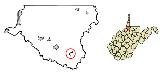
Smithfield is a town in Wetzel County, West Virginia, United States. The population was 103 at the 2020 census.

References

  1. "ArcGIS REST Services Directory". United States Census Bureau. Retrieved September 20, 2022.
  2. "US Board on Geographic Names". United States Geological Survey. October 25, 2007. Retrieved January 31, 2008.
  3. 1 2 "Explore Census Data". United States Census Bureau . Retrieved July 18, 2022.
  4. "US Gazetteer files: 2010, 2000, and 1990". United States Census Bureau. February 12, 2011. Retrieved April 23, 2011.
  5. "US Gazetteer files 2010". United States Census Bureau . Retrieved June 14, 2012.
  6. "City and Town Population Totals: 2020-2021". United States Census Bureau. July 18, 2022. Retrieved July 18, 2022.
  7. "U.S. Decennial Census". Census.gov. Retrieved May 25, 2014.
  8. Climate Summary for Wildrose, North Dakota
  9. "2020 CENSUS - SCHOOL DISTRICT REFERENCE MAP: Williams County, ND" (PDF). United States Census Bureau . Retrieved August 22, 2021.