Loyal, Oklahoma

Last updated

Loyal, Oklahoma
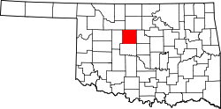
OKMap-doton-Loyal.PNG
Location of Loyal, Oklahoma
Coordinates: 35°58′22″N98°07′05″W / 35.97278°N 98.11806°W / 35.97278; -98.11806
Country United States
State Oklahoma
County Kingfisher
Area
[1]
  Total0.09 sq mi (0.23 km2)
  Land0.09 sq mi (0.23 km2)
  Water0.00 sq mi (0.00 km2)
Elevation
[2]
1,116 ft (340 m)
Population
 (2020)
  Total71
  Density797.75/sq mi (308.02/km2)
Time zone UTC-6 (Central (CST))
  Summer (DST) UTC-5 (CDT)
ZIP code
73756
Area code(s) 405/572
FIPS code 40-44300 [3]
GNIS feature ID2412923 [2]

Loyal is a town in Kingfisher County, Oklahoma, United States. The population was 79 at the 2010 census. [4]

Contents

History

A large share of the early settlers being natives of Germany, the original name of the settlement was "Kiel", after the city in northern Germany. [5] In 1917 following American entry into World War I, the name was changed to "Loyal" due to rampant anti-German sentiment. [6]

Geography

Loyal is located in western Kingfisher County 18 miles (29 km) northwest of Kingfisher, the county seat.

According to the United States Census Bureau, the town has a total area of 0.081 square miles (0.21 km2), all land. [4] The town sits next to Cooper Creek, an east-flowing tributary of the Cimarron River.

Demographics

Historical population
CensusPop.Note
1940 177
1950 125−29.4%
1960 87−30.4%
1970 10723.0%
1980 1124.7%
1990 76−32.1%
2000 816.6%
2010 79−2.5%
2020 71−10.1%
U.S. Decennial Census [7]

As of the census [3] of 2000, there were 81 people, 35 households, and 22 families residing in the town. The population density was 1,030.2 inhabitants per square mile (397.8/km2). There were 43 housing units at an average density of 546.9 per square mile (211.2/km2). The racial makeup of the town was 81.48% White, 6.17% Native American, 9.88% from other races, and 2.47% from two or more races. Hispanic or Latino of any race were 9.88% of the population.

There were 35 households, out of which 31.4% had children under the age of 18 living with them, 45.7% were married couples living together, 14.3% had a female householder with no husband present, and 34.3% were non-families. 31.4% of all households were made up of individuals, and 11.4% had someone living alone who was 65 years of age or older. The average household size was 2.31 and the average family size was 2.65.

In the town, the population was spread out, with 28.4% under the age of 18, 4.9% from 18 to 24, 29.6% from 25 to 44, 28.4% from 45 to 64, and 8.6% who were 65 years of age or older. The median age was 38 years. For every 100 females, there were 72.3 males. For every 100 females age 18 and over, there were 81.3 males.

The median income for a household in the town was $18,750, and the median income for a family was $21,250. Males had a median income of $32,500 versus $20,625 for females. The per capita income for the town was $12,673. There were 38.1% of families and 34.2% of the population living below the poverty line, including 35.0% of under eighteens and none of those over 64.

Notable person

Related Research Articles

<span class="mw-page-title-main">Kingfisher County, Oklahoma</span> County in Oklahoma, United States

Kingfisher County is a county located in the U.S. state of Oklahoma. As of the 2020 census, the population was 15,184. Its county seat is Kingfisher. The county was formed in 1890 and named Kingfisher by a vote of residents.

<span class="mw-page-title-main">Knowles, Oklahoma</span> Town in Oklahoma, United States

Knowles is a town in Beaver County, Oklahoma, United States. The population was 6 at the time of the 2020 census.

<span class="mw-page-title-main">Silo, Oklahoma</span> Town in Oklahoma, United States

Silo is a town in Bryan County, Oklahoma, United States. The population was 331 at the 2010 census, an increase of 17.4 percent from the figure of 282 recorded in 2000.

<span class="mw-page-title-main">Dickson, Oklahoma</span> Town in Oklahoma, United States

Dickson is a town in Carter County, Oklahoma, United States. The population was 1,207 at the 2010 census. It is part of the Ardmore, Oklahoma Micropolitan Statistical Area.

<span class="mw-page-title-main">Taloga, Oklahoma</span> Town in Oklahoma, United States

Taloga is a town in Dewey County, Oklahoma, United States. The population was 288 at the time of the 2020 census.

<span class="mw-page-title-main">Douglas, Oklahoma</span> Town in Oklahoma, United States

Douglas is a town in Garfield County, Oklahoma, United States. The population was 32 at the 2010 census.

<span class="mw-page-title-main">Hunter, Oklahoma</span> Town in Oklahoma, United States

Hunter is a town in Garfield County, Oklahoma, United States. The population was 165 at the 2010 census, a 4.6 percent decline from the figure of 173 in 2000.

<span class="mw-page-title-main">Waukomis, Oklahoma</span> Town in Oklahoma, United States

Waukomis is a town in Garfield County, Oklahoma, United States. The population was 1,286 at the 2010 census, an increase of 2.0 percent from 1,261 in 2000.

<span class="mw-page-title-main">Ninnekah, Oklahoma</span> Town in Oklahoma, United States

Ninnekah is a town in Grady County, Oklahoma, United States. The population was 775 at the 2020 census, a 22.7% decrease from 2010.

<span class="mw-page-title-main">Pocasset, Oklahoma</span> Town in Oklahoma, United States

Pocasset is a town in Grady County, Oklahoma, United States. The population was 183 at the 2020 census, a 17.3% increase from 2010.

<span class="mw-page-title-main">Hennessey, Oklahoma</span> Town in Oklahoma, United States

Hennessey is a town in Kingfisher County, Oklahoma, United States. The population was 2,131 at the 2010 census, up from 2,058 in 2000.

<span class="mw-page-title-main">Davenport, Oklahoma</span> Town in Oklahoma, United States

Davenport is a town in Lincoln County, Oklahoma, United States. The population was 814 at the 2010 census.

<span class="mw-page-title-main">Tryon, Oklahoma</span> Town in Oklahoma, United States

Tryon is a town in Lincoln County, Oklahoma, United States. The population was 491 at the 2010 census. The community is named after early land owner Fred S. Tryon.

<span class="mw-page-title-main">Haworth, Oklahoma</span> Town in Oklahoma, United States

Haworth is a town in McCurtain County, Oklahoma, United States. The population was 297 at the 2010 census.

<span class="mw-page-title-main">Forest Park, Oklahoma</span> Town in Oklahoma, United States

Forest Park is a town in Oklahoma County, Oklahoma, United States, and a part of the Oklahoma City metropolitan area. The population was 998 at the 2010 census.

<span class="mw-page-title-main">Hoffman, Oklahoma</span> Town in Oklahoma, United States

Hoffman is a town in Okmulgee County, Oklahoma, United States. The population was 81 at the 2020 census.

<span class="mw-page-title-main">Maramec, Oklahoma</span> Town in Oklahoma, United States

Maramec is a town in Pawnee County, Oklahoma, United States. The population was 91 at the 2010 census, a decline of 12.5 percent from the figure 104 recorded in 2000.

<span class="mw-page-title-main">Francis, Oklahoma</span> Town in Oklahoma, United States

Francis is a town in Pontotoc County, Oklahoma, United States. The population was 332 at the 2000 census.

<span class="mw-page-title-main">Cashion, Oklahoma</span> Town in Oklahoma, United States

Cashion is a town in Kingfisher and Logan counties in the U.S. state of Oklahoma. The Logan County portion of Cashion is part of the Oklahoma City Metropolitan Statistical Area. The population was 850 as of the 2020 United States census, up 6% from the 802 reported at the 2010 census.

<span class="mw-page-title-main">Fair Oaks, Oklahoma</span> Town in Oklahoma, United States

Fair Oaks is a town in Rogers and Wagoner counties in the U.S. state of Oklahoma. The population was 103 at the 2010 census, a 15.6 percent decline from the figure of 122 recorded in 2000. It is a suburb of Tulsa.

References

  1. "ArcGIS REST Services Directory". United States Census Bureau. Retrieved September 20, 2022.
  2. 1 2 U.S. Geological Survey Geographic Names Information System: Loyal, Oklahoma
  3. 1 2 "U.S. Census website". United States Census Bureau . Retrieved January 31, 2008.
  4. 1 2 "Geographic Identifiers: 2010 Census Summary File 1 (G001), Loyal town, Oklahoma". American FactFinder. U.S. Census Bureau. Archived from the original on February 13, 2020. Retrieved April 16, 2019.
  5. McIntyre, Glen V. (February 4, 2009). Kingfisher and Kingfisher County. Arcadia Publishing. p. 9. ISBN   978-1-4396-2120-2.
  6. Loyal at Oklahoma Historical Society's Encyclopedia of Oklahoma History & Culture
  7. "Census of Population and Housing". Census.gov. Retrieved June 4, 2015.