Maibara, Shiga

Last updated • 5 min readFrom Wikipedia, The Free Encyclopedia
Maibara
米原市
Mount Ibuki and N700 Series Shinkansen.jpg
The Shinkansen streaks past Mount Ibuki before reaching Maibara Station.
Flag of Maibara Shiga.svg
Emblem of Maibara, Shiga.svg
Maibara in Shiga prefecture Ja.svg
Location of Maibara in Shiga Prefecture
Japan location map with side map of the Ryukyu Islands.svg
Red pog.svg
Maibara
Location in Japan
Coordinates: 35°19′N136°17′E / 35.317°N 136.283°E / 35.317; 136.283
CountryJapan
Region Kansai
Prefecture Shiga
Government
  MayorMichio Hirao
Area
  Total
250.39 km2 (96.68 sq mi)
Population
 (September 1, 2021)
  Total
38,259
  Density150/km2 (400/sq mi)
Time zone UTC+09:00 (JST)
City hall address3-3 Shimotara, Maibara-shi, Shiga-ken
521-8501
Climate Cfa
Website Official website
Maibara city hall Maibara City Hall ac (1).jpg
Maibara city hall

Maibara (米原市, Maibara-shi) is a city in Shiga Prefecture, Japan. As of 1 September 2021, the city had an estimated population of 38,259 in 14761 households and a population density of 150 persons per km². [1] The total area of the city is 250.39 square kilometres (96.68 sq mi).

Contents

Geography

Maibara is located in northcentral Shiga Prefecture, on the eastern shore of Lake Biwa, and extending inland to the Ibuki Mountains and the border with Gifu Prefecture. Parts of the city are within the borders of the Biwako Quasi-National Park. Mount Ibuki is in the northeastern part of the prefecture. It is the highest peak in the prefecture. The Anegawa River and Amanogawa River pass through the city. About 70 percent of the city is forest.

Neighboring municipalities

Gifu Prefecture

Shiga Prefecture

Climate

Maibara has a Humid subtropical climate (Köppen Cfa) characterized by warm summers and cool winters with heavy snowfall. The average annual temperature in Maibara is 13.5 °C (56.3 °F). The average annual rainfall is 1,810 mm (71 in) with September as the wettest month. The temperatures are highest on average in August, at around 25.3 °C (77.5 °F), and lowest in January, at around 2.1 °C (35.8 °F). [2] The highest temperature ever recorded in Maibara was 36.4 °C (97.5 °F) on 14 August 2024. [3] The coldest temperature ever recorded was −12.2 °C (10.0 °F) on 4 February 2012. [3]

Climate data for Maibara (2001−2020 normals, extremes 2001−present)
MonthJanFebMarAprMayJunJulAugSepOctNovDecYear
Record high °C (°F)14.3
(57.7)
18.9
(66.0)
22.2
(72.0)
28.0
(82.4)
31.2
(88.2)
33.2
(91.8)
36.2
(97.2)
36.4
(97.5)
35.0
(95.0)
31.5
(88.7)
23.3
(73.9)
19.3
(66.7)
36.4
(97.5)
Mean daily maximum °C (°F)5.8
(42.4)
7.3
(45.1)
11.3
(52.3)
17.1
(62.8)
22.0
(71.6)
25.5
(77.9)
29.1
(84.4)
30.8
(87.4)
27.0
(80.6)
21.1
(70.0)
14.9
(58.8)
8.7
(47.7)
18.4
(65.1)
Daily mean °C (°F)2.1
(35.8)
3.1
(37.6)
6.2
(43.2)
11.7
(53.1)
16.9
(62.4)
21.0
(69.8)
24.8
(76.6)
26.0
(78.8)
22.1
(71.8)
16.0
(60.8)
10.0
(50.0)
4.7
(40.5)
13.7
(56.7)
Mean daily minimum °C (°F)−1.7
(28.9)
−1.2
(29.8)
1.0
(33.8)
5.9
(42.6)
11.8
(53.2)
16.9
(62.4)
21.5
(70.7)
22.2
(72.0)
18.0
(64.4)
11.1
(52.0)
5.0
(41.0)
0.7
(33.3)
9.3
(48.7)
Record low °C (°F)−11.9
(10.6)
−12.2
(10.0)
−7.6
(18.3)
−3.8
(25.2)
1.5
(34.7)
8.5
(47.3)
14.9
(58.8)
13.7
(56.7)
7.3
(45.1)
1.7
(35.1)
−2.7
(27.1)
−7.5
(18.5)
−12.2
(10.0)
Average precipitation mm (inches)115.0
(4.53)
93.5
(3.68)
112.4
(4.43)
115.1
(4.53)
132.5
(5.22)
168.5
(6.63)
272.2
(10.72)
153.2
(6.03)
193.7
(7.63)
149.6
(5.89)
84.9
(3.34)
129.5
(5.10)
1,735.6
(68.33)
Average snowfall cm (inches)87
(34)
57
(22)
14
(5.5)
0
(0)
0
(0)
0
(0)
0
(0)
0
(0)
0
(0)
0
(0)
0
(0)
47
(19)
200
(79)
Average precipitation days (≥ 1.0 mm)15.912.412.711.010.111.013.010.110.79.210.416.7143.2
Average snowy days (≥ 1 cm)9.25.61.3000000003.819.9
Mean monthly sunshine hours 100.9119.5164.2184.2206.3159.7163.5206.8162.4164.4137.7100.61,864.8
Source: JMA [3] [4]

Demographics

Per Japanese census data, [5] the population of Maibara has seen relatively little fluctuation over the past century.

Historical population
YearPop.±%
1920 34,839    
1930 35,839+2.9%
1940 34,860−2.7%
1950 43,369+24.4%
1960 42,214−2.7%
1970 39,128−7.3%
1980 39,355+0.6%
1990 39,600+0.6%
2000 41,251+4.2%
2010 40,060−2.9%
2020 37,225−7.1%

History

Samegai-juku Samegai02s3872.jpg
Samegai-juku

Maibara is part of ancient Ōmi Province and the route of the Tōsandō (later the Nakasendō) highway connecting Heian-kyō with the eastern provinces passed through the area. Maibara is home to three former post stations: Banba-juku, Samegai-juku and Kashiwabara-juku, and was the location of a port on Lake Biwa where travelers could shorten their journey by taking boat to Ōtsu-juku. During the Muromachi and Sengoku periods, the Kyōgoku clan domained most of Ōmi Province from their base in what is now Maibara. Most of the area came under the control of Hikone Domain during the Edo period.

With the establishment of the modern municipalities system on April 1,1889, the village of Irie was established. It was raised to town status on November 15, 1923, becoming the town of Maihara. On February 14, 2005 Maihara merged with the neighboring towns of Santō and Ibuki (all from Sakata District) and was raised to city status, [6] changing its name from "Maihara" to "Maibara" at that time. The new city name was based on the name of Japan Railways' Maibara Station which many people in Japan knew as a station on the Tōkaidō Shinkansen Line.

The adjacent town of Ōmi was merged into Maibara on October 1, 2005. Maibara was struck by an F2 tornado on June 29, 2018. The tornado caused major damage to homes and injured 8 people.

Government

Maibara has a mayor-council form of government with a directly elected mayor and a unicameral city council of 18 members. Maibara contributes two members to the Shiga Prefectural Assembly. In terms of national politics, the city is part of Shiga 2nd district of the lower house of the Diet of Japan.

Economy

The economy of Maibara is centered on agriculture and light manufacturing. There are several industrial parks in the city.

Education

Maibara has ten public elementary schools and seven public middle schools operated by the city government. There are two public high schools operated by the Shiga Prefectural Department of Education. The prefecture also operates one special education school for the handicapped.

Transportation

Railway

JR logo (central).svg JR TōkaiTōkaidō Shinkansen

JR logo (central).svg JR TōkaiTōkaidō Main Line

JR logo (west).svg JR WestBiwako Line

JR logo (west).svg JR WestHokuriku Main Line

Ohtetsu Logomark.svg Ohmi RailwayMain Line

Highway

Local attractions

Festivals and events

Related Research Articles

<span class="mw-page-title-main">Shiga Prefecture</span> Prefecture of Japan

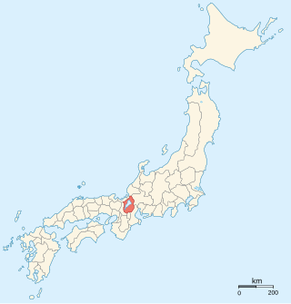
Shiga Prefecture is a landlocked prefecture of Japan located in the Kansai region of Honshu. Shiga Prefecture has a population of 1,412,916 as of 1 October 2015 and has a geographic area of 4,017 km2 (1,551 sq mi). Shiga Prefecture borders Fukui Prefecture to the north, Gifu Prefecture to the northeast, Mie Prefecture to the southeast, and Kyoto Prefecture to the west.

<span class="mw-page-title-main">Hikone, Shiga</span> City in Kansai, Japan

Hikone is a city located in Shiga Prefecture, Japan. As of 1 August 2021, the city had an estimated population of 111,958 in 49066 households and a population density of 570 persons per km². The total area of the city is 196.84 square kilometres (76.00 sq mi).

<span class="mw-page-title-main">Nagahama, Shiga</span> City in Kansai, Japan

Nagahama is a city located in Shiga Prefecture, Japan. As of 1 November 2021, the city had an estimated population of 116,043 in 46858 households and a population density of 120 persons per km2. The total area of the city is 680.79 square kilometres (262.85 sq mi).

<span class="mw-page-title-main">Kusatsu, Shiga</span> City in Kansai, Japan

Kusatsu is a city located in Shiga Prefecture, Japan. As of 31 January 2024, the city had an estimated population of 139,913 in 63,942 households and a population density of 2100 persons per km2. The total area of the city is 67.82 square kilometres (26.19 sq mi). The city is often confused with Kusatsu, Gunma Prefecture, which is a famous hot spring resort.

<span class="mw-page-title-main">Ōmi Province</span> Former province of Japan

Ōmi Province was a province of Japan, which today comprises Shiga Prefecture. It was one of the provinces that made up the Tōsandō circuit. Its nickname is Gōshū (江州). Under the Engishiki classification system, Ōmi was ranked as one of the 13 "great countries" (大国) in terms of importance, and one of the "near countries" (近国) in terms of distance from the imperial capital Kyoto.

<span class="mw-page-title-main">Maibara Station</span> Railway station in Maibara, Shiga Prefecture, Japan

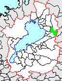
Maibara Station is an interchange passenger railway station located in the city of Maibara, Shiga, Japan. On the border between West Japan Railway Company and Central Japan Railway Company, it is jointly operated by both companies, along with the private railway operator Ohmi Railway. It is also a freight depot for the Japan Freight Railway Company.

<span class="mw-page-title-main">Santō, Shiga</span>

Santō was a town located in Sakata District, Shiga Prefecture, Japan. There was Kashiwabara-juku in Edo period.

<span class="mw-page-title-main">Ibuki, Shiga</span>

Ibuki was a town located in Sakata District, Shiga Prefecture, Japan. Mount Ibuki dominates the town.

<span class="mw-page-title-main">Maihara, Shiga</span>

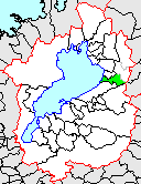
Maihara was a town located in Sakata District, Shiga Prefecture, Japan.

<span class="mw-page-title-main">Sakata District, Shiga</span>

Sakata was a district located in Shiga Prefecture, Japan.

<span class="mw-page-title-main">Ohmi Railway</span> Railway company in Shiga Prefecture, Japan

Ohmi Railway Co., Ltd. is a Japanese private railway company which operates in Shiga Prefecture, and a member of the Seibu group since 1943. The company is named after the Ōmi Province, the former name of the present-day Shiga. The railway is nicknamed "Gachakon train" by local users because of its noisy sound.

<span class="mw-page-title-main">69 Stations of the Nakasendō</span> Rest areas along old travel route in Japan

The 69 Stations of the Nakasendō are the rest areas along the Nakasendō, which ran from Nihonbashi in Edo to Sanjō Ōhashi in Kyoto. The route stretched approximately 534 km (332 mi) and was an alternate trade route to the Tōkaidō.

<span class="mw-page-title-main">Ōtsu-juku</span> Last station of the Tōkaidō and the Nakasendō

Ōtsu-juku was the last of the sixty-nine stations of the Nakasendō, as well as the last of the fifty-three stations of the Tōkaidō. It was 14 km (9 mi) from the previous post town, Kusatsu-juku, and was located in Ōmi Province. It is currently located in the present-day city of Ōtsu, Shiga Prefecture, Japan.

<span class="mw-page-title-main">Kashiwabara-juku</span> Pre-modern Japan post-station along highway

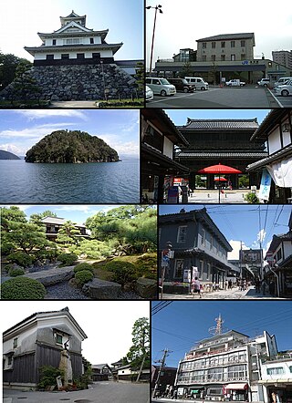
Kashiwabara-juku (柏原宿) was the sixtieth of the sixty-nine stations of the Nakasendō highway connecting Edo with Kyoto in Edo period Japan. It was located in the present-day city of Maibara, Shiga Prefecture, Japan.

<span class="mw-page-title-main">Banba-juku</span> Pre-modern Japan post-station along highway

Banba-juku was the sixty-second of the sixty-nine stations of the Nakasendō highway connecting Edo with Kyoto in Edo period Japan. It was located in the present-day city of Maibara, Shiga Prefecture, Japan.

<span class="mw-page-title-main">Toriimoto-juku</span> Pre-modern-Japan post-station along highway

Toriimoto-juku (鳥居本宿) was the sixty-third of the sixty-nine stations of the Nakasendō highway connecting Edo with Kyoto in Edo period Japan. It was located in the present-day city of Hikone, Shiga Prefecture, Japan, overlooking Lake Biwa.

<span class="mw-page-title-main">Samegai-juku</span> Pre-modern Japan post-station along highway

Samegai-juku was the sixty-first of the sixty-nine stations of the Nakasendō highway connecting Edo with Kyoto in Edo period Japan. It was located in the present-day city of Maibara, Shiga Prefecture, Japan.

<span class="mw-page-title-main">Musa-juku</span> Pre-modern Japan post-station along highway

Musa-juku (武佐宿) was the sixty-sixth of the sixty-nine stations of the Nakasendō highway connecting Edo with Kyoto in Edo period Japan. It was located in the present-day city of Ōmihachiman, Shiga Prefecture, Japan. Other kanji used to write "Musa" included 牟佐 and 身狭, but 武佐 became the official kanji in the Edo period.

<span class="mw-page-title-main">Kashiwabara Station</span> Railway station in Maibara, Shiga Prefecture, Japan

Kashiwabara Station is a passenger railway station located in the city of Maibara, Shiga Prefecture, Japan, operated by the Central Japan Railway Company.

<span class="mw-page-title-main">Kamaha Castle</span> Historical Japanese castle in Maibara

Kamaha Castle was a Sengoku period yamashiro-style Japanese castle located in the Banba neighborhood of the city of Maibara, Shiga Prefecture, in the Kansai region of Japan. Its ruins have been protected as a National Historic Site since 2005.

References

  1. "Maibara city official statistics" (in Japanese). Japan.
  2. Maibara climate data
  3. 1 2 3 観測史上1~10位の値(年間を通じての値). JMA . Retrieved February 27, 2022.
  4. 気象庁 / 平年値(年・月ごとの値). JMA . Retrieved February 27, 2022.
  5. Maibara population statistics
  6. "市の沿革・歴史|米原市". 米原市 (in Japanese). Retrieved 2024-02-08. 滋賀県米原市は、2005年2月14日、坂田郡山東町、坂田郡伊吹町、坂田郡米原町の3つの町が合併して誕生しました。