
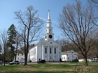
Easthampton is a city in Hampshire County, Massachusetts, United States. The city is in the Pioneer Valley, near the five colleges in the college towns of Northampton and Amherst. The population was 16,211 at the 2020 census.

Orange Center Historic District is a historic district encompassing the historic civic, commercial, and industrial heart of Orange, Massachusetts in the United States. It was listed on the National Register of Historic Places in 1989.

The Main Street Historic District encompasses the historic late 19th and early 20th-century commercial heart of Webster, Massachusetts. It consists of fourteen buildings on Main Street in downtown Webster, between High and Church Streets. This area contains the highest concentration of period commercial buildings in the town. The district was listed on the National Register of Historic Places in 1982.

The Conway Center Historic District encompasses the historic village center of Conway, Massachusetts. The district is focused on Main Street, a section of Massachusetts Route 116 that connects two major road intersections on either side of the South River. It includes properties on Main Street, Elm Street, and Academy Hill Road, and is generally representative of the growth of the community between about 1830 and 1930. The district was listed on the National Register of Historic Places in 1999.

The Heath Center Historic District encompasses a rural village with predominantly 18th- and 19th-century structures in Heath, a small agricultural town in hills of northwestern Franklin County, Massachusetts, United States. The district is centered on the junction of several roads, around which the center of the town grew. South Road arrives from the south, East Main Street and Bray Road from the east, Ledge Road from the north, and West Main Street from the west.

The US Post Office—Easthampton Main is a historic post office building at 19 Union Street in Easthampton, Massachusetts. Built in 1933, this Classical Revival building is one of the town center's most architecturally sophisticated buildings. The building was listed on the National Register of Historic Places in 1986. It is currently being used as a senior center.

The Acton Center Historic District encompasses the historic heart of the once-rural, now suburban, town of Acton, Massachusetts. The district includes properties on Main Street, Wood and Woodbury Lanes, Newtown, Concord, and Nagog Hill Roads, and has been the town's civic heart since its establishment in the 1730s. It was added to the National Register of Historic Places in 1983.

The Peabody Civic Center Historic District encompasses a well-preserved portion of the historic center of Peabody, Massachusetts. Extending along Chestnut and Franklin Streets south of Peabody City Hall, the district includes a small residential area built in the mid-19th century, as well as the city hall and St. JOhn the Baptist Roman Catholic Church, two monumental structures defining the town's civic heart. The district was added to the National Register of Historic Places in 1980.

The Spicket Falls Historic District encompasses the historic industrial and commercial heart of Methuen, Massachusetts, and one of the lower Merrimack River's best-preserved 19th century mill complexes. It is centered on the falls of the Spicket River, from which the 19th century textile mills of Methuen derived their power. The historic district, listed on the National Register of Historic Places in 1984, includes commercial and civic buildings in and near Gaunt Square, the heart of the city, and along both sides of the Spicket River between Gaunt Square and the Boston and Maine Railroad tracks south of the river. It abuts the residential Pleasant-High Historic District, which lies to its east.
The Thomas Hollis Historic District encompasses the historic civic and commercial heart of Holliston, Massachusetts. It extends along Washington Street (Massachusetts Routes 16 and 126 for about one mile, between Winter Street and Highland Street. Incorporated in 1724, this area now includes a well-preserved collection of predominantly 19th century architecture. The district was listed on the National Register of Historic Places in 1989.

The Common Historic District is a historic district encompassing the civic and institutional heart of Reading, Massachusetts. The district is centered on the town common, at the intersection of Main and Salem Streets. The common has been communally owned since at least 1737, with the original burying ground to the north. In 1769 the area's first meeting house was built, giving the area a sense of identity separate from portions of Reading that would later be set off as Wakefield and North Reading. Since then the area has become a focal point for religious and civic institutions in the town.

The Sherborn Center Historic District is a historic district encompassing the civic heart and traditional center of Sherborn, Massachusetts. Its borders consist of Farm, Sawin, Washington, and North Main streets, Zion's Lane, and the CSX railroad tracks. The district, while predominantly residential in character, also contains an important cluster of civic and religious buildings. Notable among these are the Dowse Memorial Building, a Tudor Revival structure built in 1914 to house the town library; it now houses town offices. It was donated by William Bradford Home Dowse, who also funded the construction of the 1924 Memory Statue, the town's memorial to its war dead.

The Centre Village Historic District encompasses the historic central business district of Southbridge, Massachusetts. The district includes properties on Main Street, roughly between Elm and Goddard Streets. The central area represents a fairly well preserved Late Victorian commercial center. It was added to the National Register of Historic Places in 1979.

The Clinton Downtown Historic District is a historic district located in the village of Clinton in Clinton Township in the northernmost portion of Lenawee County, Michigan. It consists of most of the 100 block of U.S. Route 12, known locally as West Michigan Avenue, plus Memorial Park at 200 West Michigan. The district was added to the National Register of Historic Places on April 27, 2010.

The Charlestown Main Street Historic District encompasses the historic heart of Charlestown, New Hampshire. It is located along Main Street, roughly between Lower Landing Road and Bridge Street, and encapsulates more than two hundred years of the town's history. The district was listed on the National Register of Historic Places in 1987.

The Norway Historic District encompasses most of the historic village center of Norway, Maine, and is reflective of the town's growth over 150 years. Although significant early-to-mid 19th century buildings survive in the village, it was significantly damaged by a major fire in 1894, resulting in the construction of a number of new brick and wood-frame buildings. The district, which is 44 acres (18 ha) in size, includes 64 historically significant residential, civic, social, and commercial buildings, and was listed on the National Register of Historic Places in 1988.
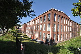
The Nashawannuck Mills Historic District of Easthampton, Massachusetts encompasses a 19th-century industrial complex on Cottage Street in the heart of the town. Most of the connected series of brick buildings were built between about 1848 and 1870, although the facilities were used for industrial purposes until 1970. The oldest building erected was by Samuel Williston for a button factory. Powered by a dam that impounded Bound Brook, the facility expanded in both size and function, eventually becoming a major producer of elastic fabrics for goods such as suspenders and webbing. The industrial works were the major economic engine in Easthampton into the 20th century. The district was listed on the National Register of Historic Places in 2015.

The Calais Historic District encompasses a city block of 19th-century commercial buildings in the center of Calais, Maine. The district, developed after a fire devastated the area in 1870, contains a cohesive concentration of brick Italianate architecture. The district was listed on the National Register of Historic Places in 1978.

The Putney Village Historic District encompasses most of the main village and town center of Putney, Vermont. Settled in the 1760s, the village saw its major growth in the late 18th and early 19th century, and includes a cohesive collection with Federal and Greek Revival buildings, with a more modest number of important later additions, including the Italianate town hall. The district was listed on the National Register of Historic Places in 1986.

The Danby Village Historic District encompasses much of the town center of Danby, Vermont. It is centered on a stretch of Main Street, roughly between Depot Street and Brook Road. The village has a cohesive collection of mid-19th century architecture, mostly residential, with a modest number of later additions. The district was listed on the National Register of Historic Places in 1983.


