Maqu County རྨ་ཆུ་རྫོང་། · 玛曲县 | |
|---|---|
 | |
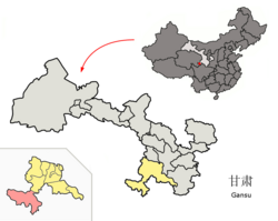 Maqu County (red) within Gannan Prefecture (yellow) and Gansu | |
 Maqu Location of the seat in Gansu  Maqu Maqu (China) | |
| Coordinates(Maqu government): 33°59′52″N102°04′22″E / 33.9977°N 102.0727°E | |
| Country | China |
| Province | Gansu |
| Autonomous prefecture | Gannan |
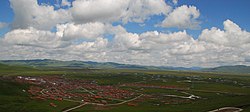
| County seat | Nyinma (Nima) |
| Area | |
| • Total | 10,190 km2 (3,930 sq mi) |
| Population (2020) [1] | |
| • Total | 57,076 |
| • Density | 5.6/km2 (15/sq mi) |
| Time zone | UTC+8 (China Standard) |
| Postal code | 747300 |
| Website | www |
- ↑ "甘南州第七次全国人口普查公报" (in Chinese). Government of Gannan Prefecture. 2021-05-27.
- ↑ "HGIS - Downloads". Archived from the original on 2008-08-28. Retrieved 2008-10-12.
- 1 2 "China". Archived from the original on 2007-08-18. Retrieved 2012-12-04.
- ↑ "统计用区划代码 www.stats.gov.cn" (in Chinese). XZQH. Retrieved 2012-05-26.
- ↑ 中国气象数据网 – WeatherBk Data (in Simplified Chinese). China Meteorological Administration . Retrieved 27 August 2023.
- ↑ 中国气象数据网 (in Simplified Chinese). China Meteorological Administration . Retrieved 27 August 2023.
| Maqu County | |||||||
|---|---|---|---|---|---|---|---|
| Chinese name | |||||||
| Simplified Chinese | 玛曲县 | ||||||
| Traditional Chinese | 瑪曲縣 | ||||||
| |||||||
| Prefecture-level cities | |
|---|---|
| Autonomous prefectures | |
| | This Gansu location article is a stub. You can help Wikipedia by expanding it. |