Xiahe County 夏河县 · བསང་ཆུ་རྫོང་། Sangqu | |
|---|---|
 | |
 Xiahe County (red) within Gannan Prefecture (yellow) and Gansu | |
 Xiahe  Xiahe | |
| Coordinates(Xiahe County government): 35°12′00″N102°31′03″E / 35.20000°N 102.51750°E | |
| Country | China |
| Province | Gansu |
| Autonomous prefecture | Gannan |
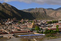
| County seat | Labrang |
| Area | |
• Total | 6,274 km2 (2,422 sq mi) |
| Population (2020) [1] | |
• Total | 86,355 |
| • Density | 14/km2 (36/sq mi) |
| Time zone | UTC+8 (China Standard) |
| Postal code | 747100 |
| Website | www |
- ↑ "甘南州第七次全国人口普查公报" (in Chinese). Government of Gannan Prefecture. 27 May 2021.
- ↑ Frederick Roelker Wulsin, Joseph Fletcher, Peabody Museum of Archaeology and Ethnology, National Geographic Society (U.S.), Peabody Museum of Salem (1979). Mary Ellen Alonso (ed.). China's inner Asian frontier: photographs of the Wulsin expedition to northwest China in 1923 : from the archives of the Peabody Museum, Harvard University, and the National Geographic Society (illustrated ed.). The Museum : distributed by Harvard University Press. p. 49. ISBN 0-674-11968-1. Archived from the original on 4 February 2021. Retrieved 28 June 2010.
{{cite book}}: CS1 maint: multiple names: authors list (link) - ↑ Dean King (2010). Unbound: A True Story of War, Love, and Survival (illustrated ed.). Hachette Digital, Inc. ISBN 978-0-316-16708-6. Archived from the original on 29 September 2021. Retrieved 28 June 2010.
- ↑ Paul Hattaway (2004). Peoples of the Buddhist world: a Christian prayer diary. William Carey Library. p. 4. ISBN 0-87808-361-8. Archived from the original on 29 September 2021. Retrieved 29 May 2011.
- ↑ Gary Geddes (2008). Kingdom of Ten Thousand Things: An Impossible Journey from Kabul to Chiapas (illustrated ed.). Sterling Publishing Company, Inc. p. 175. ISBN 978-1-4027-5344-2. Archived from the original on 30 September 2021. Retrieved 29 May 2011.
- ↑ 中国气象数据网 – WeatherBk Data (in Simplified Chinese). China Meteorological Administration . Retrieved 27 August 2023.
- ↑ 中国气象数据网 (in Simplified Chinese). China Meteorological Administration . Retrieved 27 August 2023.
- ↑ 2022年统计用区划代码和城乡划分代码:夏河县 [2022 Statistical Area Numbers and Rural-Urban Area Numbers: Xiahe County]. National Bureau of Statistics of the People's Republic of China. 2022.
External links
Wikivoyage has a travel guide for Xiahe .
- People's Government of Xiahe Official Website Chinese version
- People's Government of Xiahe Official Website English version
- Journey through China - A site with numerous pictures of Xiahe.
- The Nomadic Spirit – Picture Gallery of Xiahe
| Xiahe County | |||||||
|---|---|---|---|---|---|---|---|
| Chinese name | |||||||
| Simplified Chinese | 夏河县 | ||||||
| Traditional Chinese | 夏河縣 | ||||||
| |||||||
| Prefecture-level cities | |
|---|---|
| Autonomous prefectures | |
| International | |
|---|---|
| National | |
| | This Gansu location article is a stub. You can help Wikipedia by expanding it. |