Bluestone is a cultural or commercial name for a number of dimension or building stone varieties, including:

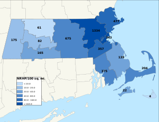
This is a list of properties and districts in Massachusetts listed on the National Register of Historic Places. There are over 4,300 listings in the state, representing about 5% of all NRHP listings nationwide and the second-most of any U.S. state, behind only New York. Listings appear in all 14 Massachusetts counties.
The Carbuncle Hill Archaeological District encompasses a collection of archaeological sites in rural western Coventry, Rhode Island. Designated by the state as sites RI-1072 through RI-1079, this discontiguous cluster of sites has the potential to increase knowledge of prehistoric patterns of stone tool procurement, development, and use. The district was added to the National Register of Historic Places in 1985, primarily for its potential to yield further information.
Gills Farm Archeological District is a historic district in Randolph, Massachusetts. The district, located in a riverine environment, encompasses a collection of prehistoric archaeological sites dating from the Middle Archaic to the Woodland period. Middle Archaic components include evidence of Neville and Stark projectile points. The quantities of Late Archaic materials found in the area suggest a period of intensive occupation and use. These sites were used as tool workshops, where stone from nearby quarry sites was processed into finished objects, typically bifacial tool blades.

The Marymoor Prehistoric Indian Site is the site of an archaeological dig in Marymoor Park, Redmond, Washington. After King County bought the property in 1962, the site was one of four sites in the park considered for excavation. The dig began in 1964, and continued for four years.

The Mount Jasper Lithic Source is a prehistoric archaeological site in Berlin, New Hampshire. Located on the slopes of Mount Jasper on the north side of the city, it includes one of the only known evidences of mining by pre-Contact Native Americans in the eastern United States. The mountain is a source of rhyolite, apparently prized for its qualities in the manufacture of stone tools. The site includes a mine shaft about 9 metres (30 ft) deep, as well as workshops at the base and summit of the mountain. The site was added to the National Register of Historic Places in 1992.

The Houserville Site is an archaeological site located near State College in Centre County, Pennsylvania, United States. Used as a stone workshop by prehistoric Native Americans ten thousand years ago, it has been recognized as a prime candidate for prehistoric preservation.
The Cooper Site is an archaeological site in Lyme, Connecticut. On a terrace of the Connecticut River near Hamburg Cove, the site has yielded evidence of Middle to Late Woodland occupation. The Late Woodland component includes evidence interpreted as the site of a wigwam, with a large number of stone chips consistent with the development of stone tools at the site. The Middle Woodland component is interpreted as a series of small camps whose occupation was relatively brief. Finds at the site have been dated as far back as c. 500 CE, and include narrow-stemmed projectile points, most of which were made from local quartz, but also from more distant chert and hornfels, some which is from quarries as far off as New Jersey. Pottery finds include fragments with dentate stamping.

The Lynch Quarry site, also known as the Lynch Knife River Flint Quarry, and designated by the Smithsonian trinomial 32DU526, is a historic pre-Columbian flint quarry located near Dunn Center, North Dakota, United States. The site was a major source of flint found at archaeological sites across North America, and it has been estimated that the material was mined there from 11,000 B.C. to A.D. 1600. The site was designated a National Historic Landmark in 2011.
Red Bluff Flint Quarries is a historic archaeological sites located near Allendale, Allendale County, South Carolina. The site consist of two outcrops of marine chert or flint, which were heavily used by Native Americans in prehistoric times as sources of tool raw materials.
The Willard Brook Quarry is a prehistoric stone quarry site in a remote portion of Piscataquis County, Maine. The quarry site is located on one of a series of outcrops near Munsungan Lake in north-central Maine, all of which have yielded stone tools found at prehistoric sites throughout northern New England. The area is known to have been frequented by Native Americans, with an extensive array of habitation sites located in the area between Munsungan and Chase Lake. The Willard Brook quarry site provides evidence that Native Americans engaged in quarrying and mining operations to recover stone suitable for conversion to tools.
The Tulauta Village Site is a prehistoric village site in far eastern Tutuila, the largest island of American Samoa. The site includes 10-13 house sites, a number of grave site, and other features, including stone enclosures interpreted as pig sties, fire pits, and walls. An upright basalt slab was found, which may have been of local religious significance. Early archaeological testing took place here in the 1970s, with more extensive examinations in the 1980s and 1990s. A large number of basalt stone flakes led an early researcher to speculate that it was a quarry site; it is more likely the inhabitants were working stone quarried from a site on the ridge above.
The Hedden Site, designated Site 4.10 by the Maine Archaeological Survey, is a prehistoric archaeological site in Kennebunk, Maine. The site has been radiocarbon dated to c. 8550 BCE, and is a rare example in the state of a completely undisturbed (unplowed), stratified site. The site was listed on the National Register of Historic Places in 1991.
The Tataga-Matau Fortified Quarry Complex, designated Site AS-34-10, is a major archaeological complex on Tutuila, the largest island of American Samoa. Located in an upland area on the western side of the island above the village of Leone, the complex consists of a series of basalt quarries and structures that archaeologists have interpreted as having a military defensive purpose. The site has been known since at least 1927, and was first formally surveyed in the 1960s. Features of the site include extraction pits, from which basalt was quarried for the manufacture of stone tools and weapons, as well as domestic features such as grinding stones. Archaeologists in 1985 noted that some of the features of the site were, including trenches and terracing, were made in areas that were unsuitable for the production of stone tools, and closely resemble known military defensive structures in other areas of the Samoan islands. The site extends along with a network of ridges for more than 1.4 kilometres (0.87 mi). Radiocarbon dating of elements of the site indicate periods of occupation and/or use from c. 200 CE to the period of European contact.

The Spiller Farm Paleoindian Site, designated Site 4.13 by the Maine Archaeological Survey, is a prehistoric archaeological site in Wells, Maine. Located overlooking a stream on the Spiller Farm property on Branch Road, it is an extensive site at which a fine collection of stone artifacts has been found, dating to c. 8,000 BCE. The site was listed on the National Register of Historic Places in 2003.
The Lake Catherine Quarry is a prehistoric stone quarry in Hot Spring County, Arkansas. The site was used as a source of black novaculite, a relatively rare form of chert. Evidence of Native American quarrying activity at the site includes quarry pits, spoil piles, and a scattered talus slope of rejected materials. The site is untainted by historic quarrying, providing a potentially significant window into prehistoric quarrying methods.
The Winooski Archeological Site, designated VT-CH-46 by state archaeologists, is a prehistoric Native American site in the city of Winooski, Vermont. First identified in 1972, it is one of the largest Native encampment sites of the Middle Woodland period in the northeastern United States. It was listed on the National Register of Historic Places in 1978, at which time it was recognized as one of just two stratified Woodland period sites in the state.

The Beaver Meadow Complex Prehistoric Archeological District is a grouping of archaeological sites in Peoples State Forest, Barkhamsted, Connecticut. It consists of eight separate sites in the Beaver Meadow area of the forest, from which radiocarbon dates from the Archaic to the Middle and Late Woodland Period have been obtained. The sites were identified during surveys conducted 1983-85 by teams from Central Connecticut State University. This work was done as part of a larger scale survey of the Connecticut sections of the upper Farmington River valley.
The Two Dogs Site is a lithic quarry site located in Person County, North Carolina. This prehistoric archaeological site dates to the Middle Archaic and Woodland Periods, and it is classified as a lithic quarry site due to the presence of thousands of lithic artifacts found there. Located in the Carolina Slate Belt, the stone materials present at Two Dogs provided prehistoric peoples with openly accessible lithic resources, predominantly for tool-making, as they passed through the site between other, more residential areas. Two Dogs was excavated from 2004-2005 following shovel testing at the beginning of the decade. The lithic materials found at the Two Dogs Site were subjected to petrographic analysis, and isotopes were geochemically tested to confirm the origins of the stone artifacts. The Two Dogs site has been determined to be neither residential or agricultural; rather, this site was exclusively an area where people from nearby sedentary civilizations could access their necessary lithic resources.


