Matoaca, Virginia

Last updated
Matoaca, Virginia
CDP
Appomattox River.jpg
The Appomattox River at Matoaca
VAMap-doton-Matoaca.PNG
Location of Matoaca, Virginia
Coordinates: 37°13′41″N77°28′14″W / 37.22806°N 77.47056°W / 37.22806; -77.47056 Coordinates: 37°13′41″N77°28′14″W / 37.22806°N 77.47056°W / 37.22806; -77.47056
CountryUnited States
State Virginia
County Chesterfield
Area
  Total2.7 sq mi (6.9 km2)
  Land2.5 sq mi (6.6 km2)
  Water0.1 sq mi (0.3 km2)
Elevation
141 ft (43 m)
Population
 (2010)
  Total2,403
  Density890/sq mi (350/km2)
Time zone UTC−5 (Eastern (EST))
  Summer (DST) UTC−4 (EDT)
FIPS code 51-50136 [1]
GNIS feature ID1497010 [2]

Matoaca is a census-designated place (CDP) in Chesterfield County, Virginia, United States. The population was 2,403 at the 2010 census. [3] It is named after the Pamunkey princess Matoaka who was better known by her nickname "Pocahontas". [4] It was near the site of an Appomattoc village Matoka or Matoks, which was reputedly her girlhood home, and the palace town of the weroansqua Oppussoquionuske. [5]

Contents

In 2016 it was listed as No. 42 in CNN Money's Top 50 Places to Live in the United States. [6]

History

Olive Hill was listed on the National Register of Historic Places in 1975. [7]

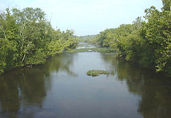
The Appomattox River is a nearly 160-mile-long water source once used as a pathway for early colonists. Its name is derived from the Indian tribe that once inhabited its banks. Because the Appomattox runs into the James River, it was a crucial port in Virginia during the Civil War as it allowed for larger ships to dock when necessary. In the spring of 1865, after the town of Petersburg had been taken over and destroyed during the Appomattox Campaign, the Confederates attempted to slow the persecution by the Union Army by burning the high bridge that ran across the Appomattox River. Failing to do so, the Confederate Army was later forced to surrender at Appomattox Court House.

Geography

Matoaca is located at 37°13′41″N77°28′14″W / 37.22806°N 77.47056°W / 37.22806; -77.47056 (37.228138, 77.470437). [8]

According to the United States Census Bureau, the CDP has a total area of 2.7 square miles (7.0 km2), of which 2.5 square miles (6.5 km2) is land and 0.1 square miles (0.26 km2), or 4.49%, is water.

Demographics

As of the census [1] of 2000, there were 2,273 people, 866 households, and 651 families residing in the CDP. The population density was 892.0 people per square mile (344.2/km2). There were 911 housing units at an average density of 357.5/sq mi (137.9/km2). The racial makeup of the CDP was 65.55% White, 32.12% African American, 0.22% Native American, 0.31% Asian, 0.04% Pacific Islander, 0.26% from other races, and 1.50% from two or more races. Hispanic or Latino of any race were 0.75% of the population.

There were 866 households, out of which 34.2% had children under the age of 18 living with them, 53.8% were married couples living together, 16.2% had a female householder with no husband present, and 24.8% were non-families. 20.8% of all households were made up of individuals, and 9.6% had someone living alone who was 65 years of age or older. The average household size was 2.62 and the average family size was 3.03.

In the CDP, the population was spread out, with 27.2% under the age of 18, 6.2% from 18 to 24, 29.7% from 25 to 44, 22.9% from 45 to 64, and 14.0% who were 65 years of age or older. The median age was 38 years. For every 100 females, there were 90.1 males. For every 100 females age 18 and over, there were 86.6 males.

The median income for a household in the CDP was $50,000, and the median income for a family was $56,163. Males had a median income of $33,722 versus $26,071 for females. The per capita income for the CDP was $19,810. About 5.8% of families and 6.2% of the population were below the poverty line, including 2.9% of those under age 18 and 10.6% of those age 65 or over.

Education

The local schools are Matoaca Elementary School, Matoaca Middle School and Matoaca High School.

In relation to education levels in Matoaca, Virginia, roughly 89% of residents have earned a high school diploma. Though the area is known for its small population, specifically about 2,400 people, nearly 1,500 of those are enrolled in school. Of those who furthered their education beyond high school, about 10% have graduated and received a college degree. To be more specific, 6% have earned an associate degree, 7% have earned a bachelor's degree, and 3% have earned a professional degree.

Related Research Articles

Appomattox County, Virginia U.S. county in Virginia

Appomattox County is a United States county located in the Piedmont region and near the center of the Commonwealth of Virginia. The county is part of the Lynchburg, VA Metropolitan Statistical Area, and its county seat is the town of Appomattox.

Brent, Florida Census-designated place in Florida, United States

Brent is a census-designated place (CDP) in Escambia County, Florida, United States. The population was 21,804 at the 2010 census. It is a principal city of the Pensacola-Ferry Pass-Brent Metropolitan Statistical Area. The community is named after Francis Celestino Brent, who played an integral role in the development of Pensacola.

Lakeside, Montana Census-designated place in Montana, United States

Lakeside is an unincorporated area and census-designated place (CDP) in Flathead County, Montana, United States. The population was 2,669 at the 2010 census, up from 1,679 in 2000.

Lower Allen, Pennsylvania Census-designated place in Pennsylvania, United States

Lower Allen is a census-designated place (CDP) in Lower Allen Township, Cumberland County, Pennsylvania, United States. The population was 6,694 at the 2010 census. It is part of the Harrisburg–Carlisle Metropolitan Statistical Area.

Madison Heights, Virginia CDP in Virginia, United States

Madison Heights is a census-designated place (CDP) in Amherst County, Virginia, United States. The population was 11,285 at the 2010 census. It is part of the Lynchburg Metropolitan Statistical Area.

Bensley, Virginia CDP in Virginia, United States

Bensley is a census-designated place (CDP) in Chesterfield County, Virginia, United States. It is an inner suburb of Richmond, Virginia. The population was 5,819 at the 2010 census. Bensley Community building is inside of Bensley park. The community building is outside of Bensley, setting in walking distance of the CDP. The community is an old village with no active government. The community is over 100 years old. A new police substation in the village is next to the old Bensley Bermuda Rescue Squad, near DuPont Spruance.

Chester, Virginia CDP in Virginia, United States

Chester is a census-designated place (CDP) in Chesterfield County, Virginia, United States. The population was 20,987 at the 2010 census.

Lincolnia, Virginia Census-designated place in Virginia, United States

Lincolnia is a census-designated place (CDP) in Fairfax County, Virginia, United States. The population was 22,828 at the 2010 census, an increase of over 44% from 2000.

Merrifield, Virginia Census-designated place in Virginia, United States

Merrifield is a census-designated place (CDP) in Fairfax County, Virginia, United States. The population was 15,212 at the 2010 census.

Newington, Virginia Census-designated place in Virginia, United States

Newington is a census-designated place (CDP) in Fairfax County, Virginia, United States. The population was 12,943 at the 2010 census. The 2010 census showed a significant decrease after half the population was split off to the newly created Newington Forest CDP.

North Springfield, Virginia Census-designated place in Virginia, United States

North Springfield is a census-designated place (CDP) in Fairfax County, Virginia, United States. The population was 7,274 at the 2010 census.

Oakton, Virginia Census-designated place in Virginia, United States

Oakton is a census-designated place (CDP) in Fairfax County, Virginia, United States. The population was 34,166 at the 2010 census. Located in Northern Virginia, its center is 16 miles (26 km) west of Washington, D.C.

Lake Monticello, Virginia Census-designated place in Virginia, United States

Lake Monticello, a private gated community, is a census-designated place (CDP) in Fluvanna County, Virginia, United States. The population was 9,920 at the 2010 census, an increase of over 44% from 2000. The community is centered on a lake of the same name, which is formed by a dam on a short tributary of the nearby Rivanna River. Lake Monticello is part of the Charlottesville Metropolitan Statistical Area. Lake Monticello was developed in the 1960s as a summer vacation home community but quickly evolved into a bedroom community of Charlottesville, and to a smaller extent of Richmond. It also has a sizable retirement age population.

Chamberlayne, Virginia Census-designated place in Virginia

Chamberlayne is a census-designated place (CDP) in Henrico County, Virginia, United States. The population was 5,456 at the 2010 census.

East Highland Park, Virginia Census-designated place in Virginia

East Highland Park is a census-designated place (CDP) in Henrico County, Virginia, in the United States. The population was 14,796 at the 2010 census.

Lakeside, Virginia Census-designated area in Virginia

Lakeside is a census-designated place (CDP) in Henrico County, Virginia, United States. It is an inner suburb of Richmond, Virginia. The population was 11,849 at the 2010 census.

Laurel, Virginia Census-designated place in Virginia

Laurel is a census-designated place (CDP) in Henrico County, Virginia. The population was 16,713 at the 2010 United States Census. It is the county seat of Henrico County.

Montrose, Virginia Census-designated place in Virginia

Montrose is a census-designated place (CDP) in Henrico County, Virginia, United States. The population was 7,993 at the 2010 census.

Yorkshire, Virginia CDP in Virginia, United States

Yorkshire is a census-designated place (CDP) in Prince William County, Virginia, United States. It is an annex of Manassas, Virginia. The population was 6,732 at the 2000 census.

Pamplin City, Virginia Town in Virginia, United States

Pamplin City is a town in Appomattox and Prince Edward counties in the U.S. state of Virginia. The population was 219 at the 2010 census.

References

  1. 1 2 "U.S. Census website". United States Census Bureau . Retrieved 2008-01-31.
  2. "US Board on Geographic Names". United States Geological Survey. 2007-10-25. Retrieved 2008-01-31.
  3. "Profile of General Population and Housing Characteristics: 2010 Demographic Profile Data (DP-1): Matoaca CDP, Virginia". United States Census Bureau . Retrieved November 29, 2011.
  4. Gannett, Henry (1905). The Origin of Certain Place Names in the United States. U.S. Government Printing Office. p.  203.
  5. Francis E. Lutz, 1954, Chesterfield - An Old Virginia County, p. 10, 15.
  6. Time, Sept. 19, 2016
  7. "National Register Information System". National Register of Historic Places . National Park Service. July 9, 2010.
  8. "US Gazetteer files: 2010, 2000, and 1990". United States Census Bureau. 2011-02-12. Retrieved 2011-04-23.