","marker-color":"#5E74F3","title":"Grand Army Plaza","marker-symbol":"entrance"}},{"type":"Feature","geometry":{"coordinates":[-73.982,40.769],"type":"Point"},"properties":{"description":"","marker-color":"#5E74F3","title":"Columbus Circle","marker-symbol":"entrance"}},{"type":"Feature","geometry":{"coordinates":[-73.958167,40.800583],"type":"Point"},"properties":{"description":"
","marker-color":"#5E74F3","title":"Frederick Douglass Circle","marker-symbol":"entrance"}},{"type":"Feature","geometry":{"coordinates":[-73.949236,40.796872],"type":"Point"},"properties":{"marker-color":"#5E74F3","title":"Duke Ellington Circle","marker-symbol":"entrance"}},{"type":"Feature","geometry":{"coordinates":[-73.9744,40.7675],"type":"Point"},"properties":{"description":"
","marker-color":"#5E74F3","title":"Wollman Rink/Victorian Gardens","marker-symbol":"skiing"}},{"type":"Feature","geometry":{"coordinates":[-73.971667,40.767778],"type":"Point"},"properties":{"description":"
","marker-color":"#5E74F3","title":"Central Park Zoo (including the Arsenal)","marker-symbol":"zoo"}},{"type":"Feature","geometry":{"coordinates":[-73.97118,40.77628],"type":"Point"},"properties":{"description":"
","marker-color":"#5E74F3","title":"The Ramble and Lake","marker-symbol":"park"}},{"type":"Feature","geometry":{"coordinates":[-73.971135,40.774123],"type":"Point"},"properties":{"description":"
","marker-color":"#5E74F3","title":"Bethesda Terrace and Fountain","marker-symbol":"water"}},{"type":"Feature","geometry":{"coordinates":[-73.971437,40.772764],"type":"Point"},"properties":{"description":"
","marker-color":"#5E74F3","title":"Central Park Mall","marker-symbol":"music"}},{"type":"Feature","geometry":{"coordinates":[-73.97449,40.766361],"type":"Point"},"properties":{"description":"
","marker-color":"#5E74F3","title":"The Pond and Hallett Nature Sanctuary","marker-symbol":"wetland"}},{"type":"Feature","geometry":{"coordinates":[-73.975001,40.775556],"type":"Point"},"properties":{"description":"
","marker-color":"#5E74F3","title":"Strawberry Fields","marker-symbol":"monument"}},{"type":"Feature","geometry":{"coordinates":[-73.974894,40.772453],"type":"Point"},"properties":{"description":"
","marker-color":"#5E74F3","title":"Sheep Meadow","marker-symbol":"pitch"}},{"type":"Feature","geometry":{"coordinates":[-73.975261,40.769939],"type":"Point"},"properties":{"description":"
","marker-color":"#5E74F3","title":"Heckscher Playground/Central Park Carousel","marker-symbol":"playground"}},{"type":"Feature","geometry":{"coordinates":[-73.96747,40.77418],"type":"Point"},"properties":{"description":"
","marker-color":"#5E74F3","title":"Conservatory Water","marker-symbol":"wetland"}},{"type":"Feature","geometry":{"coordinates":[-73.968767,40.7801],"type":"Point"},"properties":{"description":"
","marker-color":"#5E74F3","title":"Delacorte Theater/Swedish Cottage Marionette Theatre","marker-symbol":"theatre"}},{"type":"Feature","geometry":{"coordinates":[-73.966284,40.781376],"type":"Point"},"properties":{"description":"
","marker-color":"#5E74F3","title":"Great Lawn and Turtle Pond","marker-symbol":"baseball"}},{"type":"Feature","geometry":{"coordinates":[-73.965414,40.779612],"type":"Point"},"properties":{"description":"
","marker-color":"#5E74F3","title":"Cleopatra's Needle","marker-symbol":"monument"}},{"type":"Feature","geometry":{"coordinates":[-73.9631,40.7794],"type":"Point"},"properties":{"description":"
","marker-color":"#5E74F3","title":"Metropolitan Museum of Art","marker-symbol":"museum"}},{"type":"Feature","geometry":{"coordinates":[-73.96906,40.779447],"type":"Point"},"properties":{"description":"
","marker-color":"#5E74F3","title":"Belvedere Castle","marker-symbol":"lighthouse"}},{"type":"Feature","geometry":{"coordinates":[-73.960475,40.785089],"type":"Point"},"properties":{"description":"
","marker-color":"#5E74F3","title":"Jacqueline Kennedy Onassis Reservoir","marker-symbol":"wetland"}},{"type":"Feature","geometry":{"coordinates":[-73.958287,40.794646],"type":"Point"},"properties":{"description":"
","marker-color":"#5E74F3","title":"North Woods and North Meadow","marker-symbol":"tennis"}},{"type":"Feature","geometry":{"coordinates":[-73.9523,40.7938],"type":"Point"},"properties":{"description":"
","marker-color":"#5E74F3","title":"Conservatory Garden","marker-symbol":"garden"}},{"type":"Feature","geometry":{"coordinates":[-73.951667,40.796611],"type":"Point"},"properties":{"description":"
","marker-color":"#5E74F3","title":"Harlem Meer","marker-symbol":"wetland"}},{"type":"Feature","geometry":{"coordinates":[-73.954626,40.796464],"type":"Point"},"properties":{"description":"
","marker-color":"#5E74F3","title":"Lasker Rink","marker-symbol":"swimming"}},{"type":"Feature","geometry":{"coordinates":[-73.9778,40.7723],"type":"Point"},"properties":{"description":"
","marker-color":"#5E74F3","title":"Tavern on the Green","marker-symbol":"restaurant"}},{"type":"Feature","geometry":{"coordinates":[-73.974722,40.780556],"type":"Point"},"properties":{"description":"
","marker-color":"#5E74F3","title":"American Museum of Natural History","marker-symbol":"museum"}},{"type":"Feature","geometry":{"coordinates":[-73.955,40.793],"type":"Point"},"properties":{"description":"
","title":"McGowan's Pass/
McGown's Pass Tavern","marker-color":"#800"}},{"type":"Feature","geometry":{"coordinates":[-73.95629,40.79866],"type":"Point"},"properties":{"description":"","marker-color":"#5E74F3","title":"Blockhouse No. 1","marker-symbol":"lighthouse"}},{"type":"Feature","geometry":{"coordinates":[-73.962628,40.793757],"type":"Point"},"properties":{"description":"
","marker-color":"#5E74F3","title":"Tarr Family Playground","marker-symbol":"playground"}},{"type":"Feature","geometry":{"coordinates":[-73.970974,40.782273],"type":"Point"},"properties":{"description":"
","marker-color":"#5E74F3","title":"Diana Ross Playground","marker-symbol":"playground"}}]}}">
40°47′36″N73°57′18″W / 40.79333°N 73.95500°W
McGowan's Pass (sometimes spelled "McGown's") is a topographical feature of Central Park in New York City, just west of Fifth Avenue and north of 102nd Street. It pre-dates the park, and was incorporated into the park's East Drive in the early 1860s, during the park's creation. [1] A steep hill descending into a switchback road, it is a popular training route for competitive bicyclists and runners.
Although the name is usually omitted from maps today, McGowan's Pass was clearly marked on charts of the region from the Revolutionary War until the early 20th century. It acquired its name from the McGowan or McGown family who kept a tavern near there from 1756 through the Revolutionary period, and owned the surrounding property until the 1840s. The area was incorporated into Central Park after 1860, when the park's boundaries were extended north from the line of 106th Street to 110th Street, and the Harlem Meer was built in the park's northeast corner.
In Dutch Colonial days, this area of north Manhattan was part of the "commons," land administered by the community of Nieuw Haarlem as a whole. During the late 17th century, as Manhattan passed back and forth between the Dutch and English, the colony of New Harlem lost its autonomy. Common Lands were sold off in 1712. Much of this property in upper Manhattan passed to members of the extensive Benson and Dyckman families, who would continue to own much of northern Manhattan well into the 19th century. [3]
In the 1740s, Jacob Dyckman, Jr. purchased the lands along the Pass from his Uncle George. He planted orchards and built a house and outbuildings, including a public house, "At the Sign of the Black Horse." During a yellow fever epidemic in 1752, the Colonial Assembly decamped from downtown New York and met in the Black Horse tavern, while boarding a half-mile east at the farm of Dyckman's cousin, Benjamin Benson. [3]
In 1756, Dyckman decided to move back north near his family in Spuyten Duyvil, and build a new tavern by the Harlem River. He advertised his Harlem property for sale [4] and sold it a few days later to his in-laws, Daniel McGown (as he spelled himself) and Catherine Benson McGown. With their son Andrew, the McGowns ran the Black Horse tavern until after the Revolutionary War. [5]
From 1776 until 1783, during the British occupation of New York, McGowan's Pass was a key high-ground position on the route between New York City to the south and Fort Knyphausen (Fort Washington) to the north. For most of this period, the area around the Pass was the site of a Hessian encampment. [6] After the Treaty of Paris, British and Hessians marched through the Pass when evacuating north Manhattan; and George Washington likewise came through the Pass when he reentered New York on Evacuation Day, November 25, 1783.
After the war, John Leggett and his family moved into the Black Horse [7] and managed it as "Leggett's Halfway Tavern." [8]
During the War of 1812, a series of fortifications and redoubts were put up nearby. These included Blockhouse No. 1, completed two days before the war's end in 1814, which still stands on a hill in the North Woods. [9] Also built nearby were Fort Clinton, Fort Fish, and Nutter's Battery along the north side of the Pass, remnants of which can still be seen. [9] [10] There was also a gatehouse straddling the road just east of present-day Lasker Rink, near the grid coordinates of 107th Street and Lenox Avenue (formerly Sixth Avenue), where present-day East Drive makes its first downhill switchback. This 1860s route of East Drive was partially constructed over the old earthwork fortifications.
The chapel of Mount St. Vincent's Academy, a convent school built around the old McGown house, was built in 1847. It became the U.S. General Hospital or St. Joseph's Military Hospital, during the American Civil War from 1862 to 1865, after the Mount St. Vincent Academy moved north to its present campus in Riverdale. From 1859 to 1863, Frederick Law Olmsted and his family lived in the Mount St. Vincent's buildings, while Olmsted directed the landscaping of Central Park. [11] The campus existed until 1881.
From the 1860s to the 1880s, the Park Commission leased out the old school grounds as a sculpture museum and tavern, while the hill continued to be known as Mount St. Vincent's. When Central Park was being built, a lake called Harlem Meer was constructed from a natural waterway north of McGowan's Pass. A new section of East Drive was made to veer sharply to the west and south and again to the north, bypassing the Meer. [12]
A refreshment house, known as Mount St. Vincent's Hotel, opened at McGowan's Pass in 1883–1884. [13] Its proprietor until 1890 was Patrick H. McCann, brother-in-law to local Tammany Hall leader Richard Croker and sometime friend of Hugh Grant, Mayor of New York. During the Fassett Investigation in 1890, McCann testified that he lost his lease to the tavern because he refused to provide Croker, Grant and their political associates with free entertainment; in retaliation for which Croker and Grant began to bad-mouth the restaurant as a disreputable house patronized by lowlifes. [14] After McCann the tavern was leased by Gabriel Case, and finally by John Scherz.
The name of the tavern caused confusion for visiting parents who told their cab driver to take them to Mount St. Vincent's and found themselves at a large, convivial saloon in Central Park, instead of a sedate convent school. Accordingly the Park Commission officially designated the region "McGown's Pass" [ sic ] on maps and signage, and renamed the "Mount St. Vincent's Hotel" roadhouse as "McGown's Pass Tavern." [13] The tavern's new name hearkened back to a local watering-hole of a century before, the Black Horse Tavern, popularly known as McGowan's. [13]
In 1906 a plaque commemorating the "McGown" family and the Pass was installed nearby at the Fort Clinton memorial. [15] [16] [17] In 1915 the tavern was closed down and its furnishings auctioned off. The New York Times reported that its equipment, furniture, sporting prints, and "Old Gabe," the tavern's yellow parrot, brought in barely $1,500. [18] The old tavern's driveways and foundations remain in use by the Central Park Conservancy, which uses it as a composting area and has reverted to calling it "The Mount." [19]
Central Park is an urban park between the Upper West Side and Upper East Side neighborhoods of Manhattan in New York City that was the first landscaped park in the United States. It is the sixth-largest park in the city, containing 843 acres (341 ha), and the most visited urban park in the United States, with an estimated 42 million visitors annually as of 2016. It is also one of the most filmed locations in the world.
Inwood is a neighborhood in the New York City borough of Manhattan, at the northern tip of Manhattan Island, in the U.S. state of New York. It is bounded by the Hudson River to the west, Spuyten Duyvil Creek and Marble Hill to the north, the Harlem River to the east, and Washington Heights to the south.
Inwood Hill Park is a 196 acres (79 ha) public park in the Inwood neighborhood of Manhattan, New York City, operated by the New York City Department of Parks and Recreation. On a high schist ridge that rises 200 feet (61 m) above the Hudson River from Dyckman Street to the northern tip of the island, Inwood Hill Park's densely folded, glacially scoured topography contains the largest remaining old-growth forest on the island of Manhattan. The area is also known as the Shorakapkok Preserve, shorakapkok meaning 'the sitting place' in the Munsee language used by the Wecquaesgeek tribe who inhabited the area for nearly 700 years. Unlike other Manhattan parks, Inwood Hill Park is largely natural and consists of mostly wooded, non-landscaped hills.
Marble Hill is the northernmost neighborhood in the New York City borough of Manhattan. Although once part of Manhattan Island, it has been cut off from the island since 1817. The Bronx surrounds the neighborhood to the west, north, and east, while the Harlem River is its southern border.
Fort Tryon Park is a public park located in the Washington Heights and Inwood neighborhoods of the borough of Manhattan in New York City. The 67-acre (27 ha) park is situated on a ridge in Upper Manhattan, close to the Hudson River to the west. It extends mostly from 192nd Street in the south to Riverside Drive in the north, and from Broadway in the east to the Henry Hudson Parkway in the west. The main entrance to the park is at Margaret Corbin Circle, at the intersection of Fort Washington Avenue and Cabrini Boulevard.
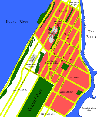
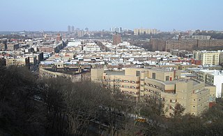
Upper Manhattan is the most northern region of the New York City borough of Manhattan. Its southern boundary has been variously defined, but some of the most common usages are 96th Street, the northern boundary of Central Park, 125th Street, or 155th Street. The term Uptown can refer to Upper Manhattan, but is often used more generally for neighborhoods above 59th Street; in the broader definition, Uptown encompasses Upper Manhattan.
Harlem River Drive is a 4.20-mile (6.76 km) controlled-access parkway in the New York City borough of Manhattan. It runs along the west bank of the Harlem River from the Triborough Bridge in East Harlem to 10th Avenue in Inwood, where the parkway ends and the road continues northwest as Dyckman Street. South of the Triborough Bridge, the parkway continues toward lower Manhattan as FDR Drive. All of Harlem River Drive is designated New York State Route 907P (NY 907P), an unsigned reference route.
Fort Washington Park is a public park located in the Washington Heights section of Upper Manhattan in New York City. It runs along the banks of the Hudson River next to Riverside Drive and the Henry Hudson Parkway from West 155th Street to Dyckman Street. The George Washington Bridge crosses above the park; below the bridge is a small point of land called Jeffrey's Hook, which is the site of the Little Red Lighthouse.
Marcus Garvey Park is a 20.16-acre (81,600 m2) park on the border between the Harlem and East Harlem neighborhoods of Manhattan, New York City. The park, centered on a massive and steep outcropping of schist, interrupts the flow of Fifth Avenue traffic, which is routed around the park via Mount Morris Park West. The park is also bounded by 120th Street to the south, 124th Street to the north, and Madison Avenue to the east.
Fort George was the name of five different forts in what is now the state of New York.
The Manhattan Waterfront Greenway is a waterfront greenway for walking or cycling, 32 miles (51 km) long, around the island of Manhattan, in New York City. The largest portions are operated by the New York City Department of Parks and Recreation. It is separated from motor traffic, and many sections also separate pedestrians from cyclists. There are three principal parts — the East, Harlem and Hudson River Greenways.
Harlem Meer is a man-made lake at the northeast corner of New York City's Central Park. It lies west of Fifth Avenue, south of 110th Street, and north of the Conservatory Garden, near the Harlem and East Harlem neighborhoods of Manhattan. The lake, as originally constructed, was 12.634 acres (51,130 m2), but after the completion in 1966 of the Lasker skating rink and swimming pool, it was reduced to approximately 11 acres (45,000 m2) in area and approximately 0.75 miles (1.21 km) in circumference.
Dyckman Street, occasionally called West 200th Street, is a street in the Inwood neighborhood of Manhattan, New York City. It is commonly considered to be a crosstown street because it runs from the Hudson River to the Harlem River and intersects Broadway. However, in its true geographical orientation, Dyckman Street runs roughly from north-northwest to south-southeast, and the majority of the street that lies southeast of Broadway runs closer to a north-south direction than east-west.
Blockhouse No. 1, colloquially known as The Blockhouse, is a small fort in the North Woods section of Central Park, Manhattan, New York City. Finished in 1814, the Blockhouse is the second-oldest structure in the park, after Cleopatra's Needle, and the oldest surviving structure originally built within the park site. It is located on an overlook of Manhattan schist, with a clear view of the flat surrounding areas north of Central Park.
The Central Park Hospital was a military hospital that operated in New York City during the American Civil War, from 1862 to 1865. It occupied the former grounds of Mount St. Vincent's Academy near 102nd St and East Drive in Central Park, just west of Fifth Avenue and atop the Revolutionary War site of McGowan's Pass. In medical and military records it is usually referred to as the United States General Hospital, Central Park; and sometimes elsewhere as St. Joseph's Military Hospital.
Fort Fish was an earthworks fortification within what is now Central Park, Manhattan, New York City. The fort was located on East Drive near 105th Street, directly across from the Central Park Conservancy's composting area, which was once a girls' school. Currently the only memorial on the Fort Fish site is a white marble bench dedicated to the memory of Andrew Haswell Green, the 19th century educator and city planner.
Nutter's Battery is a scenic overlook in the North Woods of Central Park in Manhattan, New York City, overlooking the Harlem Meer to the north. The battery was built during the War of 1812 as a small part of an extensive system of fortification intended to defend against a British invasion from the north. After the war, the wall fell into ruin and eventually disappeared. The Parks Department built a low wall in 1945 to mark the spot, and the Central Park Conservancy rebuilt the wall in 2014, adding paths and planting. The battery was named after Valentine Nutter, who owned the surrounding property.
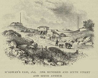
Fort Clinton was a stone-and-earthworks fortification on an elevation within what is now Central Park in New York City. It was built in 1814 near the present line of 107th Street, slightly west of Fifth Avenue. According to maps of the time, Fort Clinton was the easternmost of a connected series of forts, connected to Nutter's Battery on the west by earthworks and a gatehouse over the Old Post Road at the bottom of McGowan's Pass. Fort Clinton and Nutter's Battery were commanded from a third fort at the top of the pass, Fort Fish, which had a sweeping view of Long Island Sound, northern Manhattan, and Westchester County. Fort Fish was across the road from Fort Clinton and connected to Nutter's Battery by another line of earthworks.
North Woods and North Meadow are two interconnected features in the northern section of Central Park, New York City, close to the neighborhoods of the Upper West Side and Harlem in Manhattan. The 90-acre (36 ha) North Woods, in the northwestern corner of the park, is a rugged woodland that contains a forest called the Ravine, as well as two water features called the Loch and the Pool. The western portion of the North Woods also includes Great Hill, the third highest point in Central Park. North Meadow, a recreation center and sports complex, is immediately southeast of the North Woods. Completed in the 1860s, North Woods and North Meadow were among the last parts of Central Park to be built.