
The Lower Roxbury Historic District is a historic district encompassing an isolated pocket of 1890s mixed residential-commercial property in the lower Roxbury neighborhood of Boston, Massachusetts. Bounded by Tremont, Columbus, and Burke Streets and St. Cyprian's Place, the area contains a well-kept collection of architect designed buildings that survived late 20th-century urban redevelopment. The district was added to the National Register of Historic Places in 1994.

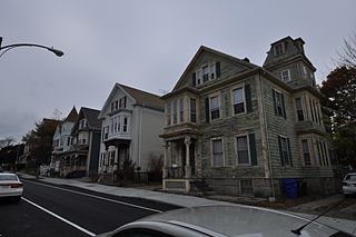
The Moreland Street Historic District is a historic district roughly bounded by Kearsarge, Blue Hill Avenues, and Warren, Waverly, and Winthrop Streets in the Roxbury neighborhood of Boston, Massachusetts. It encompasses 63 acres (25 ha) of predominantly residential urban streetscape, which was developed between about 1840 and 1920. Housing types represent a cross-section of architectural styles from the period, including Second Empire, Italianate, and Queen Anne style. It is a fairly well-preserved grouping in an area where many sections have been negatively affected by urban blight and redevelopment. One notable house is at 130 Warren Street: it is the only house in the district built out of Roxbury puddingstone. That building is currently under study as a pending landmark for the Boston Landmarks Commission.

Mount Pleasant Historic District is a historic district encompassing a cluster of well-preserved 19th-century residential buildings on Forest Street and Mount Pleasant Avenue in the Roxbury neighborhood of Boston, Massachusetts. First developed in 1833, it was one Roxbury's first speculative residential subdivision developments. The district features Greek Revival, Italianate, and Romanesque architecture, and was added to the National Register of Historic Places in 1989.

The Sumner Hill Historic District encompasses a predominantly residential area of high-quality late 19th-century residences in the Jamaica Plain neighborhood of Boston, Massachusetts. It is roughly bounded by Seaverns Avenue, Everett Street, Carolina Avenue, and Newbern Street just east of the neighborhoods commercial Centre Street area. The district features Second Empire, Italianate, and Queen Anne style architecture, and was listed on the National Register of Historic Places in 1987.

The Lower Highlands Historic District encompasses one of the oldest residential areas of Fall River, Massachusetts. The district is roughly bounded by Cherry, Main, Winter, and Bank Streets, and is located just east of the Downtown Fall River Historic District and directly south of the Highlands Historic District. This area was settled by 1810, has architecture tracing the city's growth as a major industrial center. The historic district was added to the National Register of Historic Places in 1984.
The North Bedford Historic District is a historic district roughly bounded by Summer, Parker, Pleasant and Kempton Streets in New Bedford, Massachusetts. It encompasses a predominantly residential neighborhood north of downtown New Bedford which was developed primarily in the mid 19th-century. It features a variety of worker housing of the period, as well as a number of higher quality houses built by businessmen. The district was added to the National Register of Historic Places in 1979.

The Acushnet Heights Historic District is a predominantly residential historic district in central New Bedford, Massachusetts. It encompasses a densely-built urban area about 20 acres (8.1 ha) in size, which was developed as a working-class area, beginning in the 1860s, for the many workers in the city's factories. The district was listed on the National Register of Historic Places in 1989. It abuts the North Bedford Historic District, which is just to the south, and includes the following separately-listed properties: the Union Street Railway Carbarn, the Bradford Smith Building, and the Dawson Building.

Buttonwood Park Historic District is a historic district on Kempton Street, Rockdale Avenue, Hawthorne Street and Brownell Avenue in New Bedford, Massachusetts. Its focal point is Buttonwood Park, a 97-acre (39 ha) municipal park planned by Charles Eliot in the 1890s, and part of its surrounding neighborhood. The neighborhood was developed in the first decades of the 20th century as a complement to the park, and contains a fine selection of Colonial Revival and Craftsman style houses. The district was added to the National Register of Historic Places in 2000.

The Five Corners Historic District is a historic district encompassing the central district of the village of South Williamstown, Massachusetts. It is centered at the junction of Cold Spring, Green River, New Ashford. The junction has been a prominent center in the area since 1760. Prominent buildings in the district include the South Center School, the Store at Five Corners, and the Second Congregational Church. The district was listed on the National Register of Historic Places in 1993.

Mill River Historic District is a historic district encompassing the traditional center of government and a former industrial mill village along the Konkapot River in the village of Mill River in New Marlborough, Massachusetts. The district is roughly bounded by Main Street and River Church, Southfield, Clayton, School, and Hayes Hill Roads. It encompasses about 425 acres (172 ha), and contains mostly 19th century residential and civic buildings, as well as remnants of 19th century industrial activity.

The Tavern Acres Historic District encompasses a residential development known as Tavern Acres, which was built in the 1920s with a landscape design by Henry Vincent Hubbard, then with the Olmsted Brothers landscape design firm. It is bounded by Bradstreet Rd., Green and Main Sts. and Park Way in North Andover, Massachusetts. The district encompasses Memorial Park, the Stevens Library, and properties facing Memorial Park and further along Bradstreet Road. The district was listed on the National Register of Historic Places in 1995.
The Silver Hill Historic District encompasses the first major residential subdivision of Weston, Massachusetts. It includes 79 buildings on Silver Hill and Westland Roads, and Merriam Street. The area of Silver Hill and Westland Roads was formally laid out in 1905, while Merriam Street is a very old country road which had seen some development in the 1890s. The houses in the district are predominantly Colonial Revival and Queen Anne in their styling, a relative rarity in Weston although common in other Boston suburbs. The district was added to the National Register of Historic Places in 2004.

The Spring Hill Historic District is a historic district roughly bounded by Summer, Central, Atherton, and Spring Streets in the Spring Hill area of Somerville, Massachusetts. The district encompasses the city's best-preserved residential subdivision from the mid-19th century, with later infill construction in the late 19th and early 20th centuries. The district was listed on the National Register of Historic Places in 1989.
The Belvidere Hill Historic District encompasses a residential area on the east side of Lowell, Massachusetts known for its fine 19th-century houses. The area, roughly bounded by Wyman, Belmont, Fairview, and Nesmith Streets, was developed beginning in the 1850s, and was one of the finest neighborhoods in the city, home to many of its business and civic leaders. It was listed on the National Register of Historic Places in 1995.
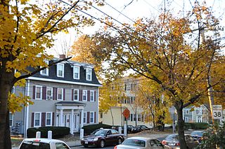
The Washington Square Historic District of Lowell, Massachusetts encompasses a historic subdivision laid out in 1832. The focal point of the subdivision is Kittridge Park, which lies on the eastern side of the district and was an original part of the subdivision plan developed by the Nesmith Brothers. It was the first significant residential subdivision in the city aimed at a wealthier clientele, and was designed by landscape architect Alexander Wadsworth. The district was added to the National Register of Historic Places in 1982, and expanded slightly in 1999.

The House at 380 Albion Street in Wakefield, Massachusetts is one of the finest Bungalow/Craftsman style houses in the town. It was built c. 1910 in a then-rural part of Wakefield that been annexed from Stoneham in the 1880s. The house was listed on the National Register of Historic Places in 1989.

Wakefield Park Historic District is a residential historic district encompassing a portion of a late-19th/early-20th century planned development in western Wakefield, Massachusetts. The district encompasses sixteen properties on 8 acres (3.2 ha) of land out of the approximately 100 acres (40 ha) that comprised the original development. Most of the properties in the district are on Park Avenue, with a few located on immediately adjacent streets.

The Railway Village Historic District is a historic district encompassing a densely populated, predominantly residential, area of eastern Milton, Massachusetts. The 30-acre (12 ha) district lies roughly between East Milton Square and the town line with neighboring Quincy. The area's significant growth occurred after the 1826 construction of the Granite Railway, which transported stone from the nearby granite quarries to the Neponset River. This resulted in the movement to the area of stone workers and related interests. The principal thoroughfare of the district is Adams Street; the district extends along Pierce Street, Granite Place, and Washington Street, and includes properties on intervening and connecting streets.
The Front Historic District is a predominantly residential historic district in Weymouth, Massachusetts. From the 18th to the 20th century, the area encompassed by this district was one of the more fashionable and desirable neighborhoods adjacent to the commercial Weymouth Landing area. It also contains remnants of a once-flourishing small scale shoe manufacturing industry. The 77-acre (31 ha) district includes nearly 150 resources, primarily residential houses, as well as a school, two cemeteries, and a small cluster of commercial buildings. The district was added to the National Register of Historic Places in 2011.

The Bellows Falls Neighborhood Historic District encompasses a residential area of the village of Bellows Falls, Vermont. Located south of downtown Bellows Falls, the area has one of the largest concentrations of well-preserved 19th century residences in southern Vermont. It was listed on the National Register of Historic Places in 2002, and enlarged in 2007.


