
The Fisherville Historic District is a historic district encompassing one of the four 19th century industrial villages of Grafton, Massachusetts. The area's first industrial activity was in 1831–2, when Peter Farnum and business partners built a brick mill there. A densely packed residential area grew around the mill complex, which achieved its present configuration c. 1909. The largest period of growth in terms of residential housing was in the last two decades of the 19th century, when a significant number of Italianate and Queen Anne worker houses were built.

Farnumsville Historic District is a historic district encompassing a historic mill village in Grafton, Massachusetts. It is located on the eastern bank of the Blackstone River, extending along Providence and Main Streets, roughly between Cross and Depot Streets, and radiating along those roads and adjacent streets. This area was one of Grafton's 19th century industrial mill villages, which was centered on the Farnum Mill, which first began operating in the second decade of the 19th century. The main mill building that survives dates to 1844, and the housing stock in the village is in a diversity of styles, built roughly between the 1820s and 1920s.

The Russells Mills Village Historic District is a historic district on Russells Mills, Rock O' Dundee, Slades Corner, Horseneck and Fisher Roads in Dartmouth, Massachusetts. It encompasses an area that was an early industrial center, flourishing from the 18th century into the early 19th century. The district was added to the National Register of Historic Places in 1985.

Hortonville is a village in the town of Swansea, Bristol County, Massachusetts, United States. The part of the village on Locust Street from Oak Street to Hortonville Road comprises the Hortonville Historic District, which was listed on the National Register of Historic Places in 1990.

The North Village Historic District encompasses a well-preserved 19th-century rural village on North Main Street in Lancaster, Massachusetts. The district includes a collection of houses, most dating to the first half of the 19th century or earlier. The district was added to the National Register of Historic Places in 1977.

The Rabbit Hill Historic District is a historic district roughly bounded by Highland, Main, Franklin, and Milford Streets in Medway, Massachusetts. It encompasses about 40 acres (16 ha) and much of a 19th-century village that developed around the Second Congregation Church, and industrial facilities that developed along the Charles River just outside the district. Most of the residential properties in the district are Federal or Greek Revival in character.

The Millis Center Historic District is an historic district on Curve, Daniels, Exchange, Irving, Lavender, Main, and Union Streets in Millis, Massachusetts. It encompasses the historic mid-to-late-19th century village center of the town, including the residential area north of Main Street, two 19th-century industrial complexes, and civic and institutional buildings. It was added to the National Register of Historic Places in 2007.

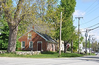
The South Egremont Village Historic District encompasses most of the village of South Egremont, Massachusetts, a well-preserved village whose architecture has seen relatively little alteration since the 1840s. It is located along Massachusetts Route 23 in the plains east of the Taconic Mountains. The district was listed on the National Register of Historic Places in 1984.

The South Lee Historic District encompasses the historic portion of the village of South Lee in Lee, Massachusetts. Extending mainly along Massachusetts Route 102 between Fairview Street and the Stockbridge town line, the village is a well-preserved 19th-century mill village, with fine Federal and Greek Revival buildings and a later 19th-century paper mill. It was listed on the National Register of Historic Places in 1999.

The Bradstreet Historic District encompasses the rural 19th-century village of Bradstreet in Hatfield, Massachusetts. It is centered at the junction of Depot Road and Main Street, and includes properties lining those two streets and Old Farm Road. Most of the buildings in the area date to the second half of the 19th century, featuring architectural styles typical of the period, including Queen Anne, Second Empire, Italianate, and Colonial Revival. The village grew on land that was originally granted to colonial governor Simon Bradstreet and divided in 1682, and has remained largely agricultural since then. The district was listed on the National Register of Historic Places in 1997.

The Granville Village Historic District is a historic district encompassing the historic Granville Village area in eastern Granville, Massachusetts. The area was developed in the 19th century as an industrial village, centered on the drum factory of Noble & Cooley on Dickinson Brook. The predominantly residential district includes a number of Greek Revival houses; it also includes the Colonial Revival public library building. It is located roughly in the area around the junction of Maple St. and Main and Granby Rds., including part of Water Street. The district was listed on the National Register of Historic Places in 1991.

The West Granville Historic District is a historic district encompassing the center of West Granville, Massachusetts. The village is composed mainly of buildings form the late 18th and early 19th centuries, including an 18th-century church and 1830s academy building. The district was listed on the National Register of Historic Places in 1991.

The Forge Village Historic District of Westford, Massachusetts, United States encompasses one of the town's historic 19th century mill villages. The focal point of the district is the mill complex of the Abbot Worsted Company, around which the village expanded after its founding in 1854. Prior to its founding the area was the site of a number of blacksmithies and iron forging operations, and was the site of a fulling mill in the 18th century. The center of the district is at the junction of East and West Prescott Streets with Pleasant Street, radiating away to ballfields on West Prescott, Abbot Street at Pleasant, and just beyond Orchard Street on East Prescott. Worker housing occupies a number of adjacent streets in the area.

The Graniteville Historic District of Westford, Massachusetts, United States, encompasses one of the town's historic 19th century industrial villages. The area was, until the arrival of the railroad in 1847, primarily known for its granite quarries. The railroad's arrival prompted the construction of an industrial mill by Charles G. Sargent, and the area developed rapidly thereafter. A significant amount of housing stock, as well as civic institutional buildings, were built during the second half of the 19th century. The district is bounded on the east by River Street and on the south by Bridge Street and North Main Street. The western edge of the district runs just before North Main Street's junction with West Street, northward and then eastward to encompass a number of quarry sites, before meeting North Main Street at River Street.

The Common Historic District is a historic district encompassing the civic and institutional heart of Reading, Massachusetts. The district is centered on the town common, at the intersection of Main and Salem Streets. The common has been communally owned since at least 1737, with the original burying ground to the north. In 1769 the area's first meeting house was built, giving the area a sense of identity separate from portions of Reading that would later be set off as Wakefield and North Reading. Since then the area has become a focal point for religious and civic institutions in the town.

The Common District encompasses the main civic center of Wakefield, Massachusetts. It is centered on the historic town common, just south of Lake Quannapowitt, which was laid in 1644, when it became the heart of Old Reading. The area was separated from Reading as South Reading in 1818, and renamed Wakefield in 1868. The 25 acre district includes the buildings that line the common on Common Street and Main Street, which include the town hall, public library, YMCA, post office, and several churches. It was listed on the National Register of Historic Places in 1990.

The Taftsville Historic District encompasses a historic 19th-century industrial village that is mostly in Woodstock, Vermont. Flanking the Ottauquechee River and extending up Happy Valley Road, the area developed around a metal tool factory established by members of the Taft family in 1793. Important elements from its early history include the Taftsville Store, built by the Taft family in 1840, and the Taftsville Covered Bridge, built in 1836. The district was listed on the National Register of Historic Places in 2001.

The Head of the River Historic District is a historic district encompassing a village area at the head of navigation of the Acushnet River, which separates Acushnet and New Bedford, Massachusetts. The village is centered at the junction of Tarkiln Hill Road, River Road, and Mill Road in New Bedford, and Main Street in Acushnet. The area went through two significant periods of development: the first was in the late 18th and early 19th century, and the second was in the early 20th century. The district was listed on the National Register of Historic Places in 2009.
The New Ipswich Center Village Historic District encompasses the historic center of the rural town of New Ipswich, New Hampshire. The center village is the town's most densely populated area, with a history dating to the town's founding in 1735. The district extends along Turnpike Road between King and Porter Roads, and southward in a roughly triangular shape, the southern point of which is at the junction of Main Street and Willard Road. The village includes a large number of residences, which were mainly agricultural at first, but also include a number of properties built as summer resort houses in the late 19th and early 20th centuries. It also includes most of the town's historic civic buildings, including its historic town hall, and the Barrett House, now a museum property owned by Historic New England. The district was listed on the National Register of Historic Places in 1991.

The Jewell Town District of South Hampton, New Hampshire, encompasses a colonial-era industrial village with a history dating to 1687. It is centered at the junction of West Whitehall and Jewell Streets, which is just south of a bend in the Powwow River, the source of the power for the mills that were built here. The area was settled in 1687 by Thomas Jewell, and by the early 19th century included a variety of mills as well as a bog iron works. The district now includes only remnants of its industrial past, and features a collection of 18th and early-19th century residential architecture. The district was listed on the National Register of Historic Places in 1983.


