Melrose, Oregon

Last updated
Melrose, Oregon
Melrose grange hall.JPG
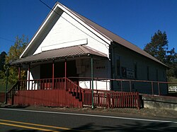
The grange hall at Melrose
USA Oregon location map.svg
Red pog.svg
Melrose, Oregon
Usa edcp location map.svg
Red pog.svg
Melrose, Oregon
Coordinates: 43°15′10″N123°27′27″W / 43.2528610°N 123.4574581°W / 43.2528610; -123.4574581 Coordinates: 43°15′10″N123°27′27″W / 43.2528610°N 123.4574581°W / 43.2528610; -123.4574581
Country United States
State Oregon
County Douglas
Area
[1]
  Total4.35 sq mi (11.26 km2)
  Land4.35 sq mi (11.26 km2)
  Water0.00 sq mi (0.00 km2)
Elevation
420 ft (128 m)
Population
 (2020) [2]
  Total834
  Density191.77/sq mi (74.05/km2)
Time zone UTC-8 (Pacific (PST))
  Summer (DST) UTC-7 (PDT)
ZIP code
97471
Area code(s) 458 and 541
FIPS code 41-47350
GNIS feature ID1124051

Melrose is an unincorporated community and census-designated place in Douglas County, Oregon, United States. [3] As of the 2010 census, it had a population of 735. [4] It was named by Henry Scott for Melrose Abbey in Scotland. Its post office, at first named Hogan, was established on May 18, 1887, and James McKinney was the first postmaster. [5] Named earlier on as French Settlement, Oregon.

Demographics

Historical population
CensusPop.
2020 834
U.S. Decennial Census [6] [2]

Related Research Articles

<span class="mw-page-title-main">Elkton, Oregon</span> City in Oregon, United States

Elkton is a city in Douglas County, Oregon, United States. It is located on the lower Umpqua River, at the junction of Oregon Route 38 and Oregon Route 138, about 20 miles (32 km) west of Interstate 5 and about 14 miles (23 km) west of Drain. The population was 195 at the 2010 census, an increase from 147 people in 2000.

<span class="mw-page-title-main">Tri-City, Oregon</span> Unincorporated community in the state of Oregon, United States

Tri-City is a census-designated place (CDP) and unincorporated community in Douglas County, Oregon, United States. The population was 3,931 at the 2010 census. The community in Missouri Bottom near the Umpqua River is named for the three cities among which it is centered: Myrtle Creek, Canyonville and Riddle. The Tri City School District probably originated the name, which was later adopted by the local sewer district and the former Tri City State Airport.

<span class="mw-page-title-main">Carlton, Oregon</span> City in Oregon, United States

Carlton is a city in Yamhill County, Oregon, United States. The population was 2,135 as of the 2020 Census.

<span class="mw-page-title-main">Mapleton, Oregon</span> Unincorporated community in the state of Oregon, United States

Mapleton is an unincorporated community in Lane County, Oregon, United States. It is located on Oregon Route 126 and the Siuslaw River, 45 miles (72 km) west of Eugene and 15 miles (24 km) east of Florence. It is also the western terminus of Oregon Route 36. As of the 2000 census, Mapleton had a total population of 918.

<span class="mw-page-title-main">Mount Hood, Oregon</span> Unincorporated community in the state of Oregon, United States

Mount Hood is an unincorporated community and census-designated place (CDP) in Hood River County, Oregon, United States, about 3 miles (5 km) northeast of Parkdale on Oregon Route 35. As of the 2010 census it had a population of 286. Mount Hood is the terminus of Oregon Route 281, the Hood River Highway.

<span class="mw-page-title-main">Westport, Oregon</span> Unincorporated community in the state of Oregon, United States

Westport is an unincorporated community and census-designated place on the Columbia River in Clatsop County, Oregon, United States. As of the 2010 census, it had a population of 321.

<span class="mw-page-title-main">Knappa, Oregon</span> Unincorporated community in the state of Oregon, United States

Knappa is an unincorporated community and census-designated place located on the south bank of the Columbia River in Clatsop County, Oregon, United States, approximately 12 miles (19 km) directly east of Astoria. Knappa faces the Columbia River, where several islands comprise the Lewis and Clark National Wildlife Refuge.

<span class="mw-page-title-main">Mulino, Oregon</span> Unincorporated community in the state of Oregon, United States

Mulino, Oregon is a hamlet and census-designated place (CDP) located in Clackamas County, Oregon, United States, on Oregon Route 213 between the cities of Oregon City and Molalla. As of the 2010 census it had a population of 2,103.

<span class="mw-page-title-main">Days Creek, Oregon</span> Unincorporated community in the state of Oregon, United States

Days Creek is an unincorporated community and census-designated place in Douglas County, Oregon, United States. At the 2010 census it had a population of 272.

Merlin is an unincorporated community and census-designated place (CDP) in Josephine County, Oregon, United States. As of the 2010 census it had a population of 1,615. The area is known for sport fishing and whitewater rafting on the Rogue River. Merlin's ZIP code is 97532.

<span class="mw-page-title-main">Ruch, Oregon</span> Unincorporated community in the state of Oregon, United States

Ruch is an unincorporated community and census-designated place (CDP) in Jackson County, Oregon, United States. It is located on Oregon Route 238, southeast of Grants Pass. As of the 2010 census it had a population of 840.

<span class="mw-page-title-main">Brogan, Oregon</span> Unincorporated community in Oregon, US

Brogan is an unincorporated community and Census-designated place (CDP) in Malheur County, Oregon, United States, on U.S. Route 26. Brogan was founded by D. M. Brogan in 1909, and when a post office was established in the locality on April 23 that year, it was named for him. Brogan is located on the north end of the now-abandoned Union Pacific Railroad branch line from Vale.

<span class="mw-page-title-main">Blodgett, Oregon</span> Unincorporated community in the state of Oregon, United States

Blodgett is a census-designated place (CDP) and unincorporated community in Benton County, Oregon, United States, where Oregon Route 180 meets U.S. Route 20 in the Central Oregon Coast Range 15 miles (24 km) west of Corvallis. It is near the confluence of the Tumtum and Marys rivers. As of the 2010 census, the community had a population of 58.

<span class="mw-page-title-main">Tumalo, Oregon</span> Unincorporated community in the state of Oregon, United States

Tumalo is an unincorporated community and census-designated place (CDP) in Deschutes County, Oregon, United States. As of the 2010 census it had a population of 488. In the Klamath language, tumolo means "wild plum," a plentiful shrub in south central Oregon. Tumola means "ground fog," which may have described Tumalo Creek. Tumallowa, the original name of Tumalo Creek, means "icy water."

<span class="mw-page-title-main">Warren, Oregon</span> Unincorporated community in the state of Oregon, United States

Warren is an unincorporated community and census-designated place in Columbia County, Oregon, United States, located on U.S. Route 30 north of Scappoose and south of St. Helens on Scappoose Bay of the Multnomah Channel. As of the 2010 census it had a population of 1,787.

<span class="mw-page-title-main">Wimer, Oregon</span> Unincorporated community in the state of Oregon, United States

Wimer is an unincorporated community and census-designated place (CDP) in Jackson County, Oregon, United States. As of the 2010 census it had a population of 678. Wimer lies along Evans Creek north of the city of Rogue River.

Lacomb is a census-designated place and unincorporated community in Linn County, Oregon, United States, located about 10 miles (16 km) northeast of Lebanon. It was named in December 1889 by W.J. Turnidge, a son of a pioneer. As of the 2019 Census it had a population of 481.

Fair Oaks is an unincorporated community and census-designated place in Douglas County, in the U.S. state of Oregon. It lies at the south end of Driver Valley and along Calapooya Creek, between Sutherlin and Nonpareil by road and upstream from Oakland along the creek. As of the 2010 census, it had a population of 278.

<span class="mw-page-title-main">Peoria, Oregon</span> Unincorporated community in the state of Oregon, United States

Peoria is an unincorporated community and census-designated place (CDP) in Linn County, Oregon, United States. It is on the right bank of the Willamette River at river mile 141 between Eugene and Corvallis. Lacking stores and services, it is a cluster of houses plus a county park along Peoria Road, about 8 miles (13 km) south of Oregon Route 34 and 12 miles (19 km) north of Harrisburg. As of the 2010 census, the population was 94.

Foots Creek is an unincorporated community and census-designated place (CDP) in Jackson County, in the U.S. state of Oregon. It lies along Oregon Route 99 near the mouth of Foots Creek, where it empties into the Rogue River. Interstate 5 and Valley of the Rogue State Park are on the side of the river opposite Foots Creek.

References

  1. "ArcGIS REST Services Directory". United States Census Bureau. Retrieved October 12, 2022.
  2. 1 2 "Census Population API". United States Census Bureau. Retrieved Oct 12, 2022.
  3. "Melrose". Geographic Names Information System . United States Geological Survey, United States Department of the Interior. November 28, 1980. Retrieved October 23, 2011.
  4. "Profile of General Population and Housing Characteristics: 2010 Demographic Profile Data (DP-1): Melrose CDP, Oregon". United States Census Bureau . Retrieved February 13, 2012.
  5. McArthur, Lewis A.; McArthur, Lewis L. (2003) [1928]. Oregon Geographic Names (7th ed.). Portland, Oregon: Oregon Historical Society Press. p. 635. ISBN   978-0875952772.
  6. "Census of Population and Housing". Census.gov. Retrieved June 4, 2016.