
The Peak District is an upland area in England at the southern end of the Pennines. Mostly in Derbyshire, it extends into Cheshire, Greater Manchester, Staffordshire, West Yorkshire and South Yorkshire. It includes the Dark Peak, where moorland is found and the geology is dominated by gritstone, and the White Peak, a limestone area with valleys and gorges. The Dark Peak forms an arc on the north, east and west sides; the White Peak covers central and southern tracts. The historic Peak District extends beyond the National Park, which excludes major towns, quarries and industrial areas. It became the first of the national parks of England and Wales in 1951. Nearby Manchester, Stoke-on-Trent, Derby and Sheffield send millions of visitors – some 20 million live within an hour's ride. Inhabited from the Mesolithic era, it shows evidence of the Neolithic, Bronze and Iron Ages. Settled by the Romans and Anglo-Saxons, it remained largely agricultural; mining arose in the Middle Ages. Richard Arkwright built cotton mills in the Industrial Revolution. As mining declined, quarrying grew. Tourism came with the railways, spurred by the landscape, spa towns and Castleton's show caves.
Derbyshire is a ceremonial and non-metropolitan county in the East Midlands, England. The county is the westernmost in the East Midlands. It covers much of the Peak District National Park, the southern end of the Pennine range of hills and part of the National Forest. It is bordered by Greater Manchester to the north-west, West Yorkshire to the north, South Yorkshire to the north-east, Nottinghamshire to the east, Leicestershire to the south-east, Staffordshire to the west and south-west, and Cheshire to the west. The county's largest settlement and only city, Derby, is now administered as a unitary authority. The rest of Derbyshire remains in the Derbyshire County Council local authority area.

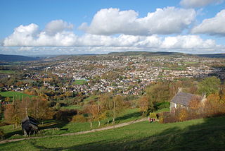
Glossop is a market town in the Borough of High Peak, Derbyshire, England. It is located 15 miles (24 km) east of Manchester, 24 miles (39 km) north-west of Sheffield and 32 miles (51 km) north of the county town, Matlock. Glossop lies near Derbyshire's borders with Cheshire, Greater Manchester, South Yorkshire and West Yorkshire. It is between 150 and 300 metres above sea level and is bounded by the Peak District National Park to the south, east and north.

The River Etherow is a river in northern England, and a tributary of the River Goyt. Although now passing through South Yorkshire, Derbyshire and Greater Manchester, it historically formed the ancient county boundary between Cheshire and Derbyshire. The upper valley is known as Longdendale. The river has a watershed of approximately 30 square miles (78 km2), and the area an annual rainfall of 52.5 inches (1,330 mm).

High Peak is a local government district with borough status in Derbyshire, England. The borough compromises high moorland plateau in the Dark Peak area of the Peak District National Park. The district stretches from Holme Moss in the north to Sterndale Moor in the south, and from Hague Bar in the west to Bamford in the east. The population of the borough taken at the 2011 Census was 90,892. The borough is unusual in having two administrative centres for its council, High Peak Borough Council; the offices are based in both Buxton and Glossop. The borough also contains other towns including Chapel-en-le-Frith, Hadfield, New Mills and Whaley Bridge.

The Dark Peak is the higher and wilder part of the Peak District in England, mostly forming the northern section but also extending south into its eastern and western margins. It is mainly in Derbyshire but parts are in Staffordshire, Cheshire, Greater Manchester, West Yorkshire and South Yorkshire.

Kinder Scout is a moorland plateau and national nature reserve in the Dark Peak of the Derbyshire Peak District in England. Part of the moor, at 636 metres (2,087 ft) above sea level, is the highest point in the Peak District, in Derbyshire and the East Midlands; in an early text this summit was identified as the Peak, and the whole area is often referred to locally as The Peak or The Peaks. In excellent weather conditions, the city of Manchester and the Greater Manchester conurbation can be seen from the western edges, as well as Winter Hill near Bolton and the mountains of Snowdonia in North Wales.
Royal Air Force Nutts Corner or more simply RAF Nutts Corner is a former Royal Air Force station located 2.7 miles (4.3 km) east of Crumlin, County Antrim, Northern Ireland and 9.2 miles (14.8 km) north west of Belfast.
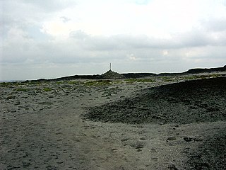
Bleaklow is a high, largely peat-covered, gritstone moorland in the Derbyshire High Peak near the town of Glossop. It is north of Kinder Scout, across the Snake Pass (A57), and south of the A628 Woodhead Pass. Much of it is nearly 2,000 feet (610 m) above sea level and the shallow bowl of Swains Greave on its eastern side is the source of the River Derwent.

Hayfield is a village and civil parish in High Peak, Derbyshire, England, with a population of around 2,700. The village is 3 miles (4.8 km) east of New Mills, 4.5 miles (7.2 km) south of Glossop and 10 miles (16 km) north of Buxton, in the basin of the River Sett.

Snake Pass is a hill pass in the Derbyshire section of the Peak District, crossing the Pennines between Glossop and the Ladybower Reservoir at Ashopton. The road was engineered by Thomas Telford and opened in 1821. The pass carries the A57 road between Manchester and Sheffield, but it is no longer the main signposted route between those two cities, with traffic instead directed through the Woodhead Pass to the north.

Consolidated Liberator I was the service name of the first Consolidated B-24 Liberator four-engined bombers to see use with the Royal Air Force (RAF).

The 427th Aircraft Sustainment Group is an inactive United States Air Force (USAF) organization. Its last assignment was with the 327th Aircraft Sustainment Wing of Air Force Materiel Command (AFMC) at Tinker Air Force Base, Oklahoma, where it was inactivated in 2010.
RAF Harpur Hill was a Royal Air Force base, situated at Harpur Hill near Buxton, Derbyshire in England. The site was operational from 1938 to 1960 and was mainly used as an underground munitions storage facility. It became the largest ammunitions dump in the country across the 500 acres (200 ha) site.

Brown Knoll is one of the highest hills in the Peak District in central England. It rises to a height of 569 metres (1,867 ft) above the head of the Edale valley and about 3 kilometres (1.9 mi) south-southwest of the Peak's highest point, Kinder Scout.

Featherbed Top is an open, flat-topped hill, 544 metres (1,785 ft) high, in the Peak District in the county of Derbyshire in England.

Chinley, Buxworth and Brownside is a civil parish within the High Peak district, which is in the county of Derbyshire, England. Partially rural with several villages contained within, its population was 2,796 residents in the 2011 census. The parish is 150 miles (240 km) north west of London, 35 miles (56 km) north west of the county city of Derby, and 1+1⁄3 miles (2.1 km) north of the nearest market town of Chapel-en-le-Frith. Being on the edge of the county border, it shares a boundary with the parishes of Chapel-en-le-Frith, Edale, Hayfield, New Mills and Whaley Bridge. A substantial portion of the parish is within the Peak District national park.

The Bleaklow Bomber was a US Air Force (USAF) Boeing RB-29A Superfortress that crashed near Higher Shelf Stones on Bleaklow in the Peak District in 1948. It was modified as a reconnaissance aircraft, rather than a bomber.

The Peak District Mountain Rescue Organisation (PDMRO) is a UK registered charity which was formed in 1964. The purpose of PDMRO is "to save life and alleviate distress, primarily in Upland and Mountain areas". This is achieved by conducting search and rescue missions for walkers, climbers and missing persons in and around the Peak District National Park.

The Buxton Mountain Rescue Team is a UK registered charity operating search and rescue missions from its base at Dove Holes near Buxton in Derbyshire. The team covers an area of about 400 square miles across Derbyshire, Staffordshire and Cheshire.


