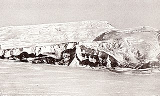
The Queen Maud Mountains are a major group of mountains, ranges and subordinate features of the Transantarctic Mountains, lying between the Beardmore and Reedy Glaciers and including the area from the head of the Ross Ice Shelf to the Antarctic Plateau in Antarctica. Captain Roald Amundsen and his South Pole party ascended Axel Heiberg Glacier near the central part of this group in November 1911, naming these mountains for the Norwegian queen Maud of Wales. Despite the name, they are not located within Queen Maud Land.

Hanover is an unincorporated community in the Baltimore/Annapolis area in northwestern Anne Arundel County and eastern Howard County in the U.S. state of Maryland, located south of Baltimore.

The Trough is a 6-mile long wooded gorge carved by the South Branch Potomac River (SBPR) and situated in the Allegheny Mountains of Hampshire and Hardy Counties, West Virginia, USA. The area was the site of a 1756 skirmish of the French and Indian War, known as the "Battle of the Trough".
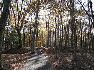
The Fort Mill Ridge Wildlife Management Area is located on 217 acres (0.88 km2) two miles (3 km) southwest of Romney in Hampshire County, West Virginia. Fort Mill Ridge WMA is owned by the West Virginia Division of Natural Resources. The Fort Mill Ridge Civil War Trenches are located at the top of the Fort Mill Ridge access road.
The Fort Mill Ridge Civil War Trenches are battle trenches in West Virginia that were originally dug between 1861 and 1862 to be later used in 1863 for the civil war. These trenches lined with chestnut logs by the Confederate artillery during the American Civil War to defend the approaches to Romney on the Northwestern Turnpike and the South Branch Potomac River. The trenches were then refurbished between March and June 1863 by the 54th Pennsylvania Infantry and the 1st West Virginia Infantry. When Colonel Jacob M. Campbell garrisoned Union forces at Romney, camps were set up at nearby at Mechanicsburg Gap.. The Confederates might have created these trenches but all throughout the war the Union had control of these trenches.

Mill Creek Mountain is a continuous mountain ridge that runs northeast through Hampshire and Hardy counties in the Eastern Panhandle region of the U.S. state of West Virginia. Rising to its greatest elevation of 2,650 feet (808 m) at High Knob, Mill Creek is a folded mountain ridge, belonging to the Ridge-and-Valley Appalachians. Mill Creek Mountain forms the western edge of the South Branch Potomac River Valley and is named for Mill Creek that carves through it at Mechanicsburg Gap allowing the Northwestern Turnpike to pass through as well. Along with Sawmill Ridge, Mill Creek Mountain forms the Trough along the South Branch.
Ruskin is a rural, naturally-treed community, about 35 miles east of Vancouver on the north shore of the Fraser River. It was named around 1900 after of the English art critic, essayist, and prominent social thinker John Ruskin.
Mill Branch is a 9.1-mile-long (14.6 km) tributary stream of the Cacapon River, belonging to the Potomac River and Chesapeake Bay watersheds. The stream is located in eastern Hampshire County in West Virginia's Eastern Panhandle.

Mill Park is a neighborhood in the outer Southeast section of Portland, Oregon, United States. It borders Hazelwood on the west, north and east, and Powellhurst-Gilbert on the south.
Glacier Ridge Trail is a 14-mile-long (23 km) trail in Butler County, Pennsylvania. The trail extends from Jennings Environmental Education Center to Moraine State Park.
The Afon Crafnant is a tributary of the River Conwy, which is the main river of the Conwy valley in north-west Wales.

Lee Ridge is a residential neighbourhood located in the Mill Woods area of south Edmonton, Alberta, Canada, named after former Edmonton mayor Robert Lee.
Millbourne is a community comprising four neighbourhoods within the northwest portion of Mill Woods in the City of Edmonton, Alberta, Canada. Neighbourhoods within the community include Lee Ridge, Michaels Park, Richfield and Tweddle Place. Community representation within Millbourne are split by two community leagues. The Lee Ridge and Richfield neighbourhoods are represented by the Leefield Community League, while the Michaels Park and Tweddle Place neighbourhoods are represented by the North Millbourne Community League.

Clerques is a commune in the Pas-de-Calais department in the Hauts-de-France region of France.

Balsam Lake Mountain is one of the Catskill Mountains, located in the Town of Hardenburgh, New York, United States. It is the westernmost of the range's 35 High Peaks. Its exact height has not been determined, but the highest contour line on topographic maps, 3,720 feet (1,130 m), is usually given as its elevation.

De Hondsrug is a smock mill in Weerdinge, Drenthe, which has been restored to working order. The mill was built in 1910 and is listed as a Rijksmonument, number 14964.

Polhemustown is an unincorporated community located within Upper Freehold Township in Monmouth County, New Jersey, United States. The community is mostly made up of farmland with a few homes and businesses scattered around the area. Polhemustown is centered about the intersection of County Route 539, Polhemustown Road, and Holmes Mill Road.
Reeding is a technique wherein "reeds" are carved or milled into a surface.

Ashcombe Mill was a post mill near the village of Kingston near Lewes, East Sussex, England. It was built in 1828 on Kingston ridge to the east of the village, probably by the millwright Samuel Medhurst of Lewes, who was responsible for building several other windmills in the area. That original mill was destroyed during a gale in 1916.

Mill Crook is a 5.9 hectare biological Site of Special Scientific Interest east of Towcester in Northamptonshire. Mill Crook and Grafton Regis Meadow are a 7.9 hectare nature reserve managed by the Wildlife Trust for Bedfordshire, Cambridgeshire and Northamptonshire.


