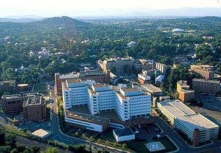
Charlottesville, colloquially known as C'ville and officially named the City of Charlottesville, is an independent city in the Commonwealth of Virginia. It is the county seat of Albemarle County, which surrounds the city, though the two are separate legal entities. It is named after the British Queen consort Charlotte of Mecklenburg-Strelitz, who as the wife of George III was Virginia's last Queen. In 2018, an estimated 48,117 people lived within the city limits. The Bureau of Economic Analysis combines the City of Charlottesville with Albemarle County for statistical purposes, bringing its population to approximately 150,000. Charlottesville is the heart of the Charlottesville metropolitan area, which includes Albemarle, Buckingham, Fluvanna, Greene, and Nelson counties.

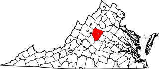
Albemarle County is a county located in the Piedmont region of the Commonwealth of Virginia. Its county seat is Charlottesville, which is an independent city and enclave entirely surrounded by the county. Albemarle County is part of the Charlottesville Metropolitan Statistical Area. As of the 2010 census, the population was 98,970, in 2018, it was estimated at 108,718.

The Southwest Mountains of Virginia are a mountain range centered on Charlottesville, parallel to and geologically associated with the Blue Ridge Mountains, which lie about 30 miles (50 km) to the west. Some of the more prominent peaks include Carters Mountains, Fan Mountain, Brush Mountain, Peters Mountain, Walton's Mountain, and Hightop Mountain.
Albemarle County, Virginia
The Meadows may refer to:

Buildings, sites, districts, and objects in Virginia listed on the National Register of Historic Places:

Keswick is an unincorporated community in Albemarle County, Virginia, United States, about six miles east of Charlottesville.

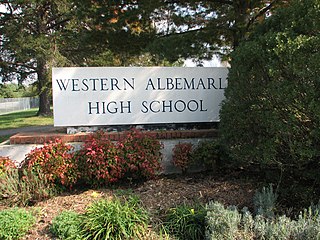
Yancey Mills is an unincorporated community in Albemarle County, Virginia, United States. Today, Yancey Mills is the site of the intersection of U.S. Route 250 and Interstate 64, the location of Western Albemarle High School, Henley Middle School, Brownsville Elementary School, and a pair of gas stations.
The Meadows is the name of some places in Virginia:
Hollymead is a census-designated place (CDP) in Albemarle County, Virginia, United States. The population as of the 2010 Census was 7,690. It is located about seven miles north of Charlottesville, near Charlottesville-Albemarle Airport.
Ivy is a census-designated place (CDP) in Albemarle County, Virginia, United States. The population as of the 2010 Census was 905. It is a small unincorporated community located on U.S. Route 250, just west of Charlottesville.
Proffit is an unincorporated community in Albemarle County, Virginia. There is no commercial activity, with only houses lining the road and a bridge under which Norfolk Southern's Piedmont Division, Washington District line runs. It is recognized as a Virginia Landmark and the Proffit Historic District was listed on the National Register of Historic Places in 1999.
Solaris is an unincorporated community in Albemarle County, Virginia. Solaris is 580 feet above sea level and is about 5 miles from the Charlottesville-Albemarle Airport.
This is a list of the National Register of Historic Places listings in Albemarle County, Virginia.
Midway is an unincorporated community in Albemarle County, Virginia. It lies at an elevation of 705 feet.

The National Weather Service Baltimore/Washington is a local office of the National Weather Service responsible for monitoring weather conditions in 44 counties in eastern West Virginia, northern and central Virginia, the majority of the state of Maryland, as well as the city of Washington, D.C. Although labeled as the NWS Baltimore/Washington, its actual location is off Old Ox Road in the Dulles section of Sterling, Virginia, adjacent to Washington Dulles International Airport.
Albemarle County Public Schools (ACPS) is a school district serving Albemarle County, Virginia. Its headquarters are in the City of Charlottesville. ACPS serves approximately 14,000 students in preschool through grade 12 in Albemarle County, Virginia, the sixth largest county by area in the Commonwealth of Virginia. A diverse locality of 726 square miles in the heart of Central Virginia, Albemarle County is a blend of primarily rural, but also suburban and urban settings.

High Meadows, also known as Peter White House, is a historic home located near Scottsville, Albemarle County, Virginia. It consists of a 1 1/2-story brick dwelling built between 1831 and 1832, and a two-story, 1883 stuccoed brick section. The 1883 addition more than tripled the size of the original dwelling and is connected by a frame, single-story passage which runs between and the length of both sections. The south facade of the 1883 section serves as the front elevation. It is two stories high and three bays wide and features a cross-gabled slate roof.
Knight of Ellerslie was an American Thoroughbred racehorse. In 1884 he won the Preakness Stakes and was second to Panique in the Belmont Stakes. These two important races would become the second and third legs of the U.S. Triple Crown series.


