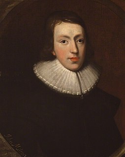
John Milton was an English poet, polemicist, man of letters, and civil servant for the Commonwealth of England under its Council of State and later under Oliver Cromwell. He wrote at a time of religious flux and political upheaval, and is best known for his epic poem Paradise Lost (1667), written in blank verse.

Paradise Lost is an epic poem in blank verse by the 17th-century English poet John Milton (1608–1674). The first version, published in 1667, consisted of ten books with over ten thousand lines of verse. A second edition followed in 1674, arranged into twelve books with minor revisions throughout and a note on the versification. It is considered by critics to be Milton's major work, and it helped solidify his reputation as one of the greatest English poets of his time.

Milton Berle was an American comedian and actor. Berle's career as an entertainer spanned over 80 years, first in silent films and on stage as a child actor, then in radio, movies and television. As the host of NBC's Texaco Star Theater (1948–55), he was the first major American television star and was known to millions of viewers as "Uncle Miltie" and "Mr. Television" during TV's golden age.

Buckinghamshire, abbreviated Bucks, is a ceremonial county in South East England which borders Greater London to the south east, Berkshire to the south, Oxfordshire to the west, Northamptonshire to the north, Bedfordshire to the north east and Hertfordshire to the east.

Milton Keynes, locally abbreviated to MK, is a large town in Buckinghamshire, England, about 50 miles (80 km) north-west of London. It is the principal settlement of the Borough of Milton Keynes, a unitary authority. At the 2011 Census, its population was almost 230,000; the Office for National Statistics estimates that it will reach 300,000 by 2025. The River Great Ouse forms its northern boundary; a tributary, the River Ouzel meanders through its linear parks and balancing lakes. Approximately 25% of the urban area is parkland or woodland and includes an SSI.

Milton is a town in Norfolk County, Massachusetts, United States and an affluent suburb of Boston. The population was 27,003 at the 2010 census. Milton is the birthplace of former U.S. President George H. W. Bush and architect Buckminster Fuller. In 2007, 2009, and 2011, Money magazine listed Milton 7th, 5th, and 2nd, respectively, on its annual list of the "Best Places to Live" in the United States.

The Borough of Milton Keynes is a unitary authority area and borough of the ceremonial county of Buckinghamshire. It is the northernmost district of the South East England Region. It was originally one of five non-metropolitan districts of Buckinghamshire, but on 1 April 1997, under a recommendation of the Local Government Commission for England, it became a self-governing unitary authority, independent from Buckinghamshire County Council.

The Regional Municipality of Halton, or Halton Region, is a regional municipality in Ontario, Canada, located in the Golden Horseshoe of Southern Ontario. It comprises the city of Burlington and the towns of Oakville, Milton, and Halton Hills. The region provides policing by the Halton Regional Police Service. The regional council's headquarters are located in Oakville. Burlington and Oakville are largely urban and suburban, while the towns of Milton and Halton Hills are more rural.

Monkston, Kents Hill and Brinklow is a civil parish that covers the Kents Hill, Brinklow, Monkston, Monkston Park and Kingston districts of Milton Keynes. As the first tier of Local Government, the Parish Council is responsible for the people, living and working in this area of Milton Keynes.

Great Blue Hill is a hill of 635 feet located within the Blue Hills Reservation in Milton and Canton, Massachusetts 10 miles (15 km) southwest of downtown Boston. It is the highest point in Norfolk County and the Greater Boston area. The modern name for the hill was given by early European explorers who, while sailing along the coastline, noticed the bluish hue of the exposed granite faces when viewed from a distance. The Blue Hills' eastern slopes face the ocean and lie within Quincy. The area attracted quarrying for its "blue granite". The name of the Massachusett Indian tribe and their language derive from the Massachusett name for the hill: massa-adchu-es-et, where massa- is "large", -adchu- is "hill", -es- is a diminutive suffix meaning "small", and -et is a locative suffix, identifying a place.
The Chicken Ranch was an illegal but tolerated brothel in the U.S. state of Texas that operated from 1905 until 1973. It was located in Fayette County about 2.5 miles (4.0 km) east of downtown La Grange. The business was established by Miss Jessie Williams, and was the basis for the 1973 ZZ Top song, "La Grange", the 1978 Broadway musical The Best Little Whorehouse in Texas, and its 1982 film adaptation.

The Wolverton and Stony Stratford Tramway was a narrow gauge street tramway between Wolverton railway station, the London and North Western Railway's (LNWR) Wolverton railway works, Stony Stratford in Buckinghamshire, and (briefly) onwards via Old Stratford to Deanshanger in Northamptonshire.

The Halton District School Board serves public school students throughout Halton Region, including the municipalities of Burlington, Halton Hills, Milton and Oakville. Its administration area is to the southwest of the city of Toronto. In 2006-2007, it served almost 50,000 students, excluding those in adult, alternative, and Community Education programs.

Governor Hutchinson's Field is a nature reserve located in Milton, Massachusetts. The field is owned by The Trustees of Reservations. The property is the only means of public access to another Trustees property, the otherwise inaccessible Pierce Reservation.

Milton is a village and civil parish about 3 miles (5 km) west of Didcot and a similar distance south of Abingdon. The 2011 Census recorded the parish's population as 1,290.

Blue Hills Parkway is a historic parkway that runs in a straight line from a crossing of the Neponset River, at the south border of Boston to the north edge of the Blue Hills Reservation in Milton, Massachusetts. It was built in 1893 to a design by the noted landscape architect, Charles Eliot, who is perhaps best known for the esplanades along the Charles River. The parkway is a connecting road between the Blue Hills Reservation and the Neponset River Reservation, and was listed on the National Register of Historic Places in 2003.

Crooked Creek is a neighborhood is located in Milton, Georgia. Surrounded by the Alpharetta Athletic Club Golf Course, it has 640 homes on over 500 acres of rolling hills.
Abbey Hill is a civil parish that covers the Two Mile Ash, Kiln Farm, and Wymbush districts of Milton Keynes. As the first tier of Local Government, the parish council is responsible for the people, living and working in this area of Milton Keynes.


