
Kalmia latifolia, commonly called mountain laurel, calico-bush, or spoonwood, is a broadleaved evergreen shrub in the heather family, Ericaceae, that is native to the eastern United States. Its range stretches from southern Maine south to northern Florida, and west to Indiana and Louisiana. Mountain laurel is the state flower of Connecticut and Pennsylvania. It is the namesake of Laurel County in Kentucky and the city of Laurel, Mississippi.

Pineville is a home rule-class city in Bell County, Kentucky, United States. It is the seat of its county. The population was 1,732 as of the 2010 census. It is located on a small strip of land between the Cumberland River and Pine Mountain.
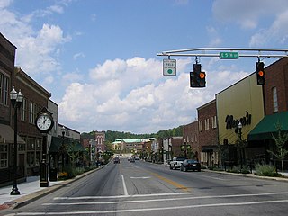
London is a home rule-class city in Laurel County, Kentucky, in the United States. It is the seat of its county. The population was 7,993 at the time of the 2010 U.S. census. London, Kentucky, is the second-largest city named London in the United States and the fourth-largest in the world. It is part of the London, Kentucky micropolitan area. Of the seventeen micropolitan areas in Kentucky, London is the largest; the London micropolitan area's 2010 Census population was 126,369. London is also home to the annual World Chicken Festival that celebrates the life of Colonel Sanders and features the world's largest skillet.
Mountain Laurel or mountain laurel may refer to:

The Laurel Highlands is a region in southwestern Pennsylvania made up of Cambria County, Fayette County, Somerset County and Westmoreland County. It has a population of about 600,000 people.

Laurel Canyon is a mountainous neighborhood/canyon located in the Hollywood Hills region of the Santa Monica Mountains, in the Hollywood Hills West district of Los Angeles, California.

Laurel Hill Tunnel is one of three original tunnels on the Pennsylvania Turnpike which were abandoned after two massive realignment projects.

Laurel Canyon Boulevard is a major street in the city of Los Angeles. It starts off at Polk Street in Sylmar in the northern San Fernando Valley near the junction of the San Diego and the Golden State (I-5)) freeways. Laurel Canyon Boulevard bypasses the city of San Fernando to the west, running parallel to I-5 in the vicinity of Pacoima and Arleta. The portion through Sun Valley passes through rock quarries and a great deal of open space.

A laurel wreath is a round wreath made of connected branches and leaves of the bay laurel, an aromatic broadleaf evergreen, or later from spineless butcher's broom or cherry laurel. It is a symbol of triumph and is worn as a chaplet around the head, or as a garland around the neck. The symbol of the laurel wreath traces back to Greek mythology. Apollo is represented wearing a laurel wreath on his head, and wreaths were awarded to victors, both in athletic competitions. This includes the ancient Olympics — for which they were made of wild olive tree known as "kotinos" (κότινος), — and in poetic meets; in Rome they were symbols of martial victory, crowning a successful commander during his triumph. Whereas ancient laurel wreaths are most often depicted as a horseshoe shape, modern versions are usually complete rings.
Laurel Mountain, also called Laurel Hill, is a long ridge in north-central West Virginia, US. Along with Rich Mountain to the south, it is considered to be the westernmost ridge of the Allegheny Mountains and the boundary between the Alleghenies and the Allegheny Plateau.

Pine Grove Furnace State Park is a protected Pennsylvania area that includes Laurel and Fuller Lakes in Cooke Township of Cumberland County. The Park accommodates various outdoor recreation activities, protects the remains of the Pine Grove Iron Works (1764), and was the site of Laurel Forge (1830), Pine Grove Park (1880s), and a brick plant (1892). The Park is 8 miles (13 km) from exit 37 of Interstate 81 on Pennsylvania Route 233.

Laurel Summit State Park is a 6-acre (2.4 ha) Pennsylvania state park in Cook Township, Westmoreland County, Pennsylvania in the United States. It is also a picnic area with a scenic view of Linn Run on the summit of Laurel Mountain. The temperatures at Laurel Summit State Park are generally several degrees cooler than the surrounding towns in the valleys. The elevation of the park is 2,739 feet (835 m) above sea level.

Laurel Mountain State Park is a 493-acre (200 ha) Pennsylvania state park in Ligonier Township, Westmoreland County and Jenner Township, Somerset County, Pennsylvania in the United States.

Laurel Hill State Park is a 3,935-acre (1,592 ha) Pennsylvania state park in Jefferson and Middlecreek Townships, Somerset County, Pennsylvania in the United States. Laurel Hill Lake is a 63-acre (25 ha) man-made lake with a dam that was constructed during the Great Depression by the young men of CCC camps SP-8-PA and SP-15-PA. Laurel Hill State Park is 8 miles (13 km) from Interstate 76 just off Pennsylvania Route 31 near Bakersville and on Pennsylvania Route 653 near Trent.
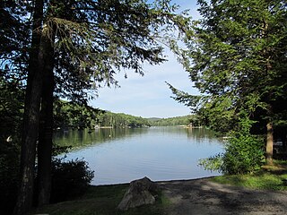
Erving State Forest is a publicly owned forest with recreational features located north of the Millers River in the towns of Erving, Warwick, and Orange, Massachusetts. The property is centered on Laurel Lake, a 51-acre (21 ha) body of water that has been a popular recreational destination since the 1930s. The forest's network of roads and hiking trails were largely created by the Civilian Conservation Corps. The forest is managed by the Department of Conservation and Recreation.

Laurel Fork North Wilderness is a U.S. Wilderness Area located in the Greenbrier Ranger District of Monongahela National Forest in West Virginia. The Wilderness protects high-elevation lands along Laurel Fork and is bordered by Middle Mountain to the west. It is a companion to Laurel Fork South Wilderness, the two being split by Randolph County Route 40. Laurel Fork North contains 9.5 miles (15.3 km) of hiking trails.

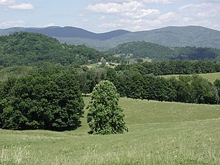
Laurel Hill, also known as Laurel Ridge or Laurel Mountain, is a 70-mile-long (110 km) mountain in Pennsylvania's Allegheny Mountains. This ridge is flanked by Negro Mountain to its east and Chestnut Ridge to its west. The mountain is home to six state parks: Laurel Ridge State Park, Laurel Mountain State Park, Linn Run State Park, Kooser State Park, Laurel Hill State Park, and Ohiopyle State Park. The 70-mile-long (110 km) Laurel Highlands Hiking Trail runs the length of the ridge.

Elliott Laurel is a 33-acre (13 ha) open space preserve located in Phillipston, Massachusetts. The property, notable for its extensive stands of mountain laurel, is managed by the land conservation non-profit organization The Trustees of Reservations. Elliott Laurel also contains woodlands, ledges, boulders, and a hayfield.

The Laurel Fork is a 15.7-mile-long (25.3 km) stream in Virginia and West Virginia, United States. The stream flows north from Highland County, Virginia, where its source and the majority of its length is located, to its mouth in Pendleton County, West Virginia. Laurel Fork is a tributary to the North Fork South Branch Potomac River, making it a part of the Potomac River watershed. The area surrounding Laurel Fork is home to several plant and animal species found nowhere else in Virginia, and is a prime example of a northern boreal forest in the state.


