
Gwinnett County is a county in the north central portion of the U.S. state of Georgia. As of 2019, the population is estimated to be 936,250, making it the second-most populous county in Georgia. Its county seat is Lawrenceville. The county is named for Button Gwinnett, one of the signatories of the Declaration of Independence.
Port Royal is an incorporated town in Caroline County, Virginia, United States. The population was 126 at the 2010 census.

The A66 is a major road in Northern England, which in part follows the course of the Roman road from Scotch Corner to Penrith. It runs from east of Middlesbrough in the ceremonial county of North Yorkshire to Workington in Cumbria. It is anomalously numbered since west of Penrith it trespasses into numbering zone 5; this is because it originally terminated at the A6 in Penrith but was extended further west in order to create one continuous east–west route. Most of what is now the A66 west of Penrith was originally A594 – only a small stub of this road numbering remains, from Maryport to Cockermouth.

A cornerback (CB) is a member of the defensive backfield or secondary in gridiron football. Cornerbacks cover receivers most of the time, but also blitz and defend against such offensive running plays as sweeps and reverses. They create turnovers through hard tackles, interceptions, and deflecting forward passes.

The Four Corners is a region of the United States consisting of the southwestern corner of Colorado, southeastern corner of Utah, northeastern corner of Arizona, and northwestern corner of New Mexico. The Four Corners area is named after the quadripoint at the intersection of approximately 37° north latitude with 109° 03' west longitude, where the boundaries of the four states meet, and are marked by the Four Corners Monument. It is the only location in the United States where four states meet. Most of the Four Corners region belongs to semi-autonomous Native American nations, the largest of which is the Navajo Nation, followed by Hopi, Ute, and Zuni tribal reserves and nations. The Four Corners region is part of a larger region known as the Colorado Plateau and is mostly rural, rugged, and arid. In addition to the monument, commonly visited areas within Four Corners include Monument Valley, Mesa Verde National Park, Chaco Canyon, Canyons of the Ancients National Monument and Canyon de Chelly National Monument. The most populous city in the Four Corners region is Farmington, New Mexico, followed by Durango, Colorado.

Madison is a former settlement, now a suburban neighborhood of northeast Nashville, in the U.S. state of Tennessee. It is incorporated as part of the Metropolitan Government of Nashville and Davidson County.
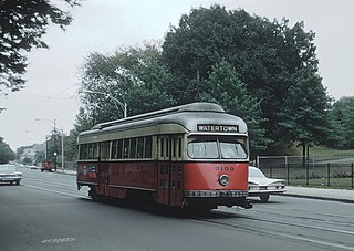
The "A" Branch or Watertown Branch was a streetcar line in the Boston, Massachusetts area, operating as a branch of the Massachusetts Bay Transportation Authority Green Line. In 1969 it was replaced by the 57 bus, though the tracks remained continuous until March 1994.
State Road 924 is a 8.5 miles (13.7 km) east–west highway connecting Interstate 75 and the Palmetto Expressway in Hialeah and SR 909 in North Miami. The westernmost 4.85 miles, named the Gratigny Parkway, is a limited access all-electronic toll road maintained by the Miami-Dade Expressway Authority ; the easternmost 3.6 miles (5.8 km) is a surface street also known as Gratigny Road. Despite its relatively short length, SR 924 is a major east–west artery in northern Miami-Dade County.
Seremban–Port Dickson Highway, SPDH, , is an expressway in Negeri Sembilan, Malaysia. It was built to shorten the traveling distance from Seremban to Port Dickson and acts as an alternative route for Federal Route 53 which has dangerous corners along the route. The 23 km (14 mi) long expressway was opened to traffic in 1998 and the first concessionaries was Seremban–Port Dickson Highway (SPDH) Sdn Bhd (a member of Melewar Corporation Berhad). Today the expressway is a part of PLUS Expressways network. The expressway may be integrated into the Malacca Strait Bridge in the future.

"Stuck on You" was Elvis Presley's first hit single after his two-year stint in the US Army, reaching number one in 1960 in the US.

Potomac and Rappahannock Transportation Commission (PRTC) is an American public transportation system in Prince William County, Virginia, plus two adjacent independent cities, Manassas and Manassas Park, that together are surrounded by the county. Services provided by PRTC include OmniRide, OmniRide Local, and OmniRide Ridesharing Service.

State Route 231 is a primary state highway in the U.S. state of Virginia. The state highway runs 49.82 miles (80.18 km) from SR 22 in Cismont north to U.S. Route 522 near Sperryville. SR 231 forms part of the connection between Charlottesville and Gordonsville, where the highway meets US 15 and US 33. The state highway also serves as the main north–south highway of Madison County, connecting the county seat of Madison, where the highway intersects US 29, with Gordonsville to the south and passing through the foothills of the Blue Ridge Mountains to the north.

VINE Transit is a public transportation service in Napa County, California, United States; it is managed under the Napa Valley Transportation Authority and operated by Transdev. The system offers extensive service throughout the County along with providing connections to other public transportation systems in adjacent counties.

The Red Deer Transit Department is part of the Community Services Division of the City of Red Deer, which lies midway between Calgary and Edmonton in the province of Alberta, Canada. The city took over operation of the public transit system from private operators in 1966. In 2009 transit service was extended to Springbrook and Gasoline Alley in Red Deer County.

Buendia was a station on the South Main Line ("Southrail") of the Philippine National Railways. Like all PNR stations, this station is at grade. The station was located at the corner of Gil Puyat Avenue and the South Luzon Expressway in Makati.

Blackwells Corner is an unincorporated community in the Antelope Valley of Kern County, California. It is located 50 miles (80 km) west-northwest of Bakersfield, at an elevation of 650 feet. Blackwells Corner is at the intersection of California State Route 46 and California State Route 33, and was the last place James Dean was seen alive prior to his death in a car wreck.

Ludwigs Corner, Pennsylvania is a town located in West Vincent Township, four miles north of Eagle, PA. Upper Uwchlan Township, Chester County, Pennsylvania.
CST Brands, Inc. was an American publicly traded fuel and convenience retailer. It was the second-largest of its kind in North America, with 1,900 outlets in the U.S. and Canada. CST Brands had 2013 revenues of about $12.8 billion and made approximately $360 million in EBITDA. Stores were concentrated in the central and southwestern U.S. states and in eastern Canada. Corner Store was the firm's primary retail brand in the US and in Canada's English speaking provinces. In Canada's French speaking provinces, Dépanneur du Coin is the company's retail brand. In addition to convenience store retail sales, CST Brands also sold fuel under a number of licensed energy brands such as Valero, Exxon, Shell, and Phillips 66.

Hendrickson Corners is an unincorporated community located along the border of Holmdel and Middletown townships in Monmouth County, New Jersey, United States. The area primarily consists of commercial businesses along the Route 35 corridor; also nearby are an apartment complex and houses in developments throughout. County Route 516 has a brief concurrency with Route 35 in Hendricksons Corners; the easternmost intersection of the two roads is where the settlement is centered.

Dela Rosa is a station on the South Main Line ("Southrail") of the Philippine National Railways. Like all PNR stations, this station is at grade. The station is located at the corner of Dela Rosa Street and the South Luzon Expressway in Makati.


