Mill Valley is a city in Marin County, California, United States, located about 14 miles (23 km) north of San Francisco via the Golden Gate Bridge. The population was 13,903 at the 2010 census.

Fall River Mills is an unincorporated town and census-designated place (CDP) in Shasta County, California, United States. The population was 573 as of the 2010 census.

Bale Grist Mill State Historic Park is a California state park located in Napa County between St. Helena and Calistoga. The park is the site of a water-powered grist mill that was built in 1846 is one of only two water-driven mills remaining west of the Mississippi River.

Skidoo was an unincorporated community in Inyo County, California. The geographical location of the old town site lies at an elevation of 5,689 feet. Skidoo is a virtual ghost town located in Death Valley National Park. It is on the National Register of Historic Places.

Burleigh H. Murray Ranch is a property in the state park system of California in the United States. It is a valley ranch located in San Mateo County inland from Half Moon Bay. The ranch was established in 1857 and became a 1,325-acre (536 ha) park in 1979. It was purchased by the State of California in 1983.

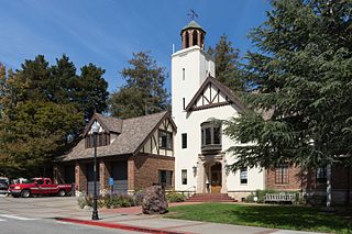
The Mill Valley Film Festival is an annual American film festival founded in 1977.

Garlock is an unincorporated community in Kern County, California. It is located 6.25 miles (10 km) east-southeast of Saltdale, at an elevation of 2169 feet.

Bothe-Napa Valley State Park is a state park of California in the United States. Located in the Napa Valley, it contains the farthest inland coast redwoods in a California state park. The 1,991-acre (806 ha) park was established in 1960.
Mill Creek is a large stream in northern California. It is an eastside tributary of the Sacramento River, draining an area of 134 square miles (350 km2) and flowing for 56.5 miles (90.9 km). The creek begins in Shasta County, California, but almost immediately flows into Tehama County, California. The creek's source is a thermal spring at an elevation of 8,200 feet (2,500 m) in Lassen Volcanic National Park. At first, the creek flows roughly south while meandering to the east and west, but the lower two-thirds of the creek flow roughly southwest until it reaches the Sacramento River at an elevation of only 200 feet (61 m), just north of Los Molinos, California.
Chloride City is a ghost town in Inyo County, California, United States. It is located 8.5 miles (14 km) north-northeast of Beatty Junction, at an elevation of 4,770 ft (1,450 m). The former settlement is now in Death Valley National Park.

Arroyo Corte Madera del Presidio is a 4.1-mile-long (6.6 km) year-round stream in southern Marin County, California, United States. This watercourse is also known as Corte Madera Creek, although the actual stream of that name flows into San Francisco Bay further north at Point San Quentin. This watercourse has a catchment basin of about 8 square miles (21 km2) and drains the south-eastern slopes of Mount Tamalpais and much of the area in and around the town of Mill Valley; this stream discharges to Richardson Bay.
Ashford Junction is an unincorporated community in Inyo County, California. It is located in Death Valley 1 mile (1.6 km) southeast of Ashford Mill, at an elevation of 118 feet below sea level.
Ashford Mill is a former mining town settlement in Inyo County, California. It was located in Death Valley, at an elevation of 121 feet below sea level. The place is now protected ruins within Death Valley National Park.

Reilly is a former settlement in Inyo County, California. It was located on the west side of the Panamint Valley, at an elevation of 2582 feet. Reilly was a silver mining community in the late 19th century.
Laverne is a former settlement in Marin County, California. It was located 1.5 miles (2.4 km) west of Mill Valley.
Navarro, formerly known as Wendling, is an unincorporated community in Mendocino County in the U.S. state of California. It is located 18 miles (29 km) west of Ukiah, at an elevation of 269 feet (82 m). It may be reached via east-west California State Route 128, which connects it to the Pacific coast to the west and to the Anderson Valley to the southeast.
Carpenter Valley is an unincorporated community in Nevada County, California, United States. Situated at the north fork of Prosser Creek, it is said to be named for John S. Carpenter, who in the 1860s was engaged in hauling logs to "Old Hobart Mills".
Belleville, California was a gold mining boomtown in the San Bernardino Mountains of San Bernardino County, California. The settlement grew up rapidly following the discovery of gold by William F. Holcomb in Holcomb Valley early 1860. Which helped the town challenge the seat of San Bernardino County. Belleville was named after Belle, the first child born in the new town. It was a busy mining town for ten years, it was virtually abandoned before the end of the 19th century. It is now a ghost town.
Union Mills is an unincorporated community in Nevada County, California. Union Mills is located in Union Valley, 4.5 miles (7.2 km) east-northeast of Truckee. It lies at an elevation of 5853 feet.
Round Valley is a former settlement in Plumas County, California, at an elevation of 4521 feet. Round Valley is located northwest of the Round Valley Reservoir, 3 miles (4.8 km) south of Greenville, and 3.5 miles (5.6 km) west-northwest of Crescent Mills.


