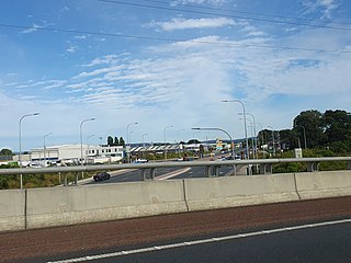
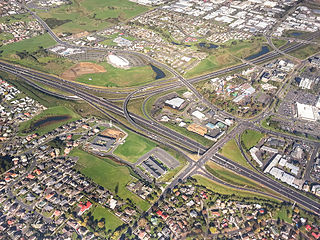
Millwater is a northern suburb of Auckland, located in New Zealand. It is about 33 kilometres (by road) north of the city centre. The Auckland Northern Motorway and Orewa River form its western and northern boundaries respectively.
Millwater was built on former farmland in 2005.[3] Development is expected to be complete in 2022, with an anticipated population of 10,000.[4]
A companion suburb of Milldale is intended on the other side of the Northern Motorway, and this will include a new primary school for the area.[5]
Demographics
Millwater covers 4.17km2 (1.61sqmi)[1] and had an estimated population of 9,740 as of June 2024,[2] with a population density of 2,336 people per km2.
Millwater had a population of 5,946 at the 2018 New Zealand census, an increase of 5,079 people (585.8%) since the 2013 census, and an increase of 5,847 people (5906.1%) since the 2006 census. There were 1,785 households, comprising 2,928 males and 3,015 females, giving a sex ratio of 0.97 males per female, with 1,605 people (27.0%) aged under 15 years, 912 (15.3%) aged 15 to 29, 2,907 (48.9%) aged 30 to 64, and 522 (8.8%) aged 65 or older.
Ethnicities were 67.2% European/Pākehā, 4.8% Māori, 1.0% Pacific peoples, 30.8% Asian, and 2.9% other ethnicities. People may identify with more than one ethnicity.
The percentage of people born overseas was 48.1, compared with 27.1% nationally.
Although some people chose not to answer the census's question about religious affiliation, 51.7% had no religion, 37.9% were Christian, 0.1% had Māori religious beliefs, 1.8% were Hindu, 0.8% were Muslim, 1.8% were Buddhist and 0.8% had other religions.
Of those at least 15 years old, 1,455 (33.5%) people had a bachelor's or higher degree, and 378 (8.7%) people had no formal qualifications. 1,383 people (31.9%) earned over $70,000 compared to 17.2% nationally. The employment status of those at least 15 was that 2,436 (56.1%) people were employed full-time, 624 (14.4%) were part-time, and 129 (3.0%) were unemployed.[6]
Takanini is a southern suburb of Auckland, New Zealand. It is located on the shores of the Pahurehure Inlet, 28 kilometres southeast of the Auckland CBD.
Henderson is a suburb of Auckland, New Zealand. It is 13 kilometres (8.1 mi) west of Auckland city centre, and two kilometres (1.2 mi) west of the Whau River, a southwestern arm of the Waitematā Harbour.
Penrose is an industrial suburb in Auckland, New Zealand. It is located to the southeast of the city centre, at a distance of about nine kilometres, between the suburbs of Oranga and Mount Wellington, and close to the Mangere Inlet, an arm of the Manukau Harbour.
Te Papapa is a suburb of Auckland, New Zealand. It is located nine kilometres to the southeast of Auckland city centre, on the northern shore of Māngere Inlet, an arm of the Manukau Harbour. The residential and light-industrial suburb lies between the suburbs of Onehunga, Penrose, and Southdown, and is at the northern end of the Māngere Bridge which connects it with the South Auckland suburb of Māngere. Train services on the Onehunga Line run through the suburb on the Onehunga Branch line, which reopened in 2010. Services at Te Papapa station commenced on 19 September 2010. Carter Holt Harvey's head office is located at 173 Captain Springs Road in the Te Papapa area. It has been suggested that the name of the suburb refers to a fortress built of rock slabs. However, at the time Te Papapa Railway Station first opened the area around was commonly known as "Pumpkin Flat" and a short article in the Auckland Star reported that the general manager of the railways had chosen to name the station after the "Maori long pumpkin or Te Papapa" in remembrance of the commonly used name.
Forrest Hill is a suburb located on the North Shore of Auckland, New Zealand.
Hillcrest is a suburb of the contiguous Auckland metropolitan area located in New Zealand. Since 2010, it has been under the jurisdiction of the Auckland Council, and is located in the North Shore, surrounded by Glenfield, Wairau Valley, Northcote and Birkenhead. The Auckland Northern Motorway passes to the east.
Waterview is a suburb of Auckland, New Zealand, located along the western side of Auckland's isthmus. Its boundaries are Oakley Creek in the east, Heron Park in the south, the Waitematā Harbour in the west, and the Northwestern Motorway and the Oakley Creek inlet in the north.
Massey is a northern suburb in West Auckland, New Zealand. It was formerly a northern suburb of Waitakere City, which existed from 1989 to 2010 before the city was amalgamated into Auckland Council. The suburb was named after former Prime Minister of New Zealand William Massey. Massey is a relatively large suburb and can be divided into three reasonably distinctive areas, Massey West, Massey East and Massey North. Parts of Massey East are also known as 'Royal Heights', which is home to the Royal Heights shopping centre.
Lincoln is a suburb in West Auckland, New Zealand. It is also the filming location of Shortland Street. The suburb is sometimes called Lincoln North or treated as part of Henderson North to avoid confusion with Lincoln in Canterbury.
Pahurehure is a suburb of Auckland, in northern New Zealand. It is located on the south-eastern shores of the Manukau Harbour, under the authority of the Auckland Council. The suburb makes up the southernmost part of the Auckland urban area.
Rosehill is a suburb of Auckland, in northern New Zealand. Located to the south of Pahurehure, under authority of the Auckland Council. The suburb makes up the southernmost part of the Auckland metropolitan area, and is located in the Manurewa-Papakura ward, one of the thirteen administrative divisions of Auckland city.
Silverdale is a village approximately 30 km north of Auckland in the North Island of New Zealand. It is located on the north bank of the Weiti River and lies to the west of the Whangaparaoa Peninsula.
Pinehill is a small suburb in the East Coast Bays area of Auckland, New Zealand. The suburb has only recently grown because of the housing estates being built in the area for the rapidly growing Albany area. Pinehill is regularly serviced by buses which go to Takapuna and the Auckland city centre. The Auckland Northern Motorway passes to the west of the suburb.
Red Beach is a suburb surrounding the beach of the same name on the Hibiscus Coast, Auckland, New Zealand, at the base of the Whangaparaoa Peninsula. The suburb of Silverdale is to the south-west, and Orewa to the north.
Manukau, or Manukau Central, is a suburb of South Auckland, New Zealand, centred on the Manukau City Centre business district. It is located 23 kilometres south of the Auckland Central Business District, west of the Southern Motorway, south of Papatoetoe, and north of Manurewa. The industrial and commercial suburb of Wiri lies to the east and south.
Rosebank is a peninsula and industrial suburb of Auckland, New Zealand. It is the westernmost point of the Auckland isthmus. The peninsula runs from the southeast in a northerly direction, with the Whau River on its west. Pollen Island and Traherne Island lie nearby in the Waitematā Harbour to the north-eastern side of the peninsula. Traherne Island is connected to the peninsula by a causeway that is part of the Northwestern Motorway.
Clendon Park is a suburb of Auckland in northern New Zealand. It is located to the west of Manurewa and north of Weymouth. The suburb is in the Manurewa-Papakura ward, one of the 21 local boards of Auckland Council.
Weymouth, also known as Weymouth by the sea, is a southern suburb of Auckland, New Zealand. It is located adjacent to Clendon Park and Manurewa, some 25 kilometres (16 mi) southeast of Auckland city centre, and is sited on a peninsula between the southeastern shore of the Manukau Harbour and that Harbour's Pahurehure Inlet.
Fairview Heights is a suburb located on the North Shore of Auckland, New Zealand. It is under local governance of Auckland Council. The area is defined by Lonely Track Road on the north, East Coast Road on the east, Oteha Valley Road on the south, and the Auckland Northern Motorway on the west. Until the end of the 20th century, the area was rural.
Oteha is an Auckland suburb, which is under local governance of Auckland Council. The area is defined by Oteha Valley Road on the north, East Coast Road on the east, Spencer Road on the south, and the Auckland Northern Motorway on the west.
This page is based on this Wikipedia article Text is available under the CC BY-SA 4.0 license; additional terms may apply. Images, videos and audio are available under their respective licenses.