Archaeocyatha is a taxon of extinct, sessile, reef-building marine sponges that lived in warm tropical and subtropical waters during the Cambrian Period. It is believed that the centre of the Archaeocyatha origin is now located in East Siberia, where they are first known from the beginning of the Tommotian Age of the Cambrian, 525 million years ago (mya). In other regions of the world, they appeared much later, during the Atdabanian, and quickly diversified into over a hundred families.

Vinson Massif is a large mountain massif in Antarctica that is 21 km (13 mi) long and 13 km (8 mi) wide and lies within the Sentinel Range of the Ellsworth Mountains. It overlooks the Ronne Ice Shelf near the base of the Antarctic Peninsula. The massif is located about 1,200 kilometres (750 mi) from the South Pole. Vinson Massif was discovered in January 1958 by U.S. Navy aircraft. In 1961, the Vinson Massif was named by the Advisory Committee on Antarctic Names (US-ACAN), after Carl G. Vinson, United States congressman from the state of Georgia, for his support for Antarctic exploration. On November 1, 2006, US-ACAN declared Mount Vinson and Vinson Massif to be separate entities. Vinson Massif lies within the unrecognised Chilean claim under the Antarctic Treaty System.
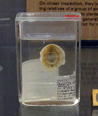
Monoplacophora, meaning "bearing one plate", is a polyphyletic superclass of molluscs with a cap-like shell, inhabiting deep sea environments. Extant representatives were not recognized as such until 1952; previously they were known only from the fossil record, and were thought to have become extinct 375 million years ago.

The Ellsworth Mountains are the highest mountain ranges in Antarctica, forming a 350 km (217 mi) long and 48 km (30 mi) wide chain of mountains in a north to south configuration on the western margin of the Ronne Ice Shelf in Marie Byrd Land. They are bisected by Minnesota Glacier to form the Sentinel Range to the north and the Heritage Range to the south. The former is by far the higher and more spectacular with Mount Vinson constituting the highest point on the continent. The mountains are located within the Chilean Antarctic territorial claim but outside of the Argentinian and British ones.

The Heritage Range is a major mountain range, 160 km (99 mi) long and 48 km (30 mi) wide, situated southward of Minnesota Glacier and forming the southern half of the Ellsworth Mountains in Antarctica. The range is complex, consisting of scattered ridges and peaks of moderate height, escarpments, hills and nunataks, with the various units of relief set off by numerous intervening glaciers.

The geology of Antarctica covers the geological development of the continent through the Archean, Proterozoic and Phanerozoic eons.

Xystridura Whitehouse, 1936 is a genus of Redlichiid trilobite described originally from the Middle Cambrian (Miaolingian) strata of Queensland, Australia. The genus ranges upwards from Ordian into Florian Stages in terms of Australian Cambrian stratigraphic nomenclature.

Knightoconus antarcticus is an extinct species of fossil monoplacophoran from the Cambrian Minaret Formation of Antarctica. It is thought to represent an ancestor to the cephalopods. It had a chambered conical shell, but lacked a siphuncle.
The Kirengellids are a group of problematic Cambrian fossil shells of marine organisms. The shells bear a number of paired muscle scars on the inner surface of the valve.
Buggisch Peak is a peak rising to 1,445 metres (4,740 ft), 1 nautical mile (2 km) southwest of Lester Peak, Edson Hills, in the Heritage Range, Ellsworth Mountains, Marie Byrd Land. It was mapped by the United States Geological Survey from surveys and from U.S. Navy aerial photographs, 1961–66, and named by the Advisory Committee on Antarctic Names after Werner Buggisch, a German member of the field party with the United States Antarctic Research Program Ellsworth Mountains Expedition, 1979–80, led by Gerald F. Webers.
Conglomerate Ridge is a ridge, 1 nautical mile (2 km) long, located 4 nautical miles (7 km) east-southeast of Mount Bursik in the Soholt Peaks, Heritage Range, Ellsworth Mountains of Antarctica. The ridge trends northwest–southeast and rises to about 1,650 metres (5,400 ft). It was so named from the conglomerate composition of the ridge by Gerald F. Webers, leader of the United States Antarctic Research Program Ellsworth Mountains Expedition, 1979–80.

Splettstoesser Glacier is a glacier, 35 nautical miles long, draining from the plateau just south of Founders Escarpment and flowing east-northeast through the Heritage Range to the south of Founders Peaks and Anderson Massif to enter the Minnesota Glacier. Named by the University of Minnesota Ellsworth Mountains Party which explored the area in 1961-62 for John F. Splettstoesser, geologist with that party.

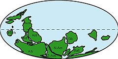
The Shackleton Limestone is a Cambrian limestone formation of the Byrd Group of Antarctica. The age of the formation is established to be Cambrian Stage 3, dated at ranging from 520 to 516 Ma. This period correlates with the End-Botomian mass extinction. Fossils of trilobites and Marocella mira and Dailyatia have been found in the formation, named after Ernest Shackleton, who led a failed expedition into Antarctica. At time of deposition, the Antarctic Plate has been established to be just south of the equator as part of the supercontinent Pannotia, contrasting with its present position at 82 degrees southern latitude.
The Shady Dolomite is a geologic formation composed of marine sedimentary rocks of early Cambrian age. It outcrops along the eastern margin of the Blue Ridge province in the southeastern United States and can be found in outcrops in the states of Alabama, Georgia, Tennessee, North Carolina, and Virginia. It can also be found in the subsurface of Kentucky, Ohio, and West Virginia. The Shady is predominantly composed of dolomite and limestone with lesser amounts of mudrock. It contains fossils of trilobites, archaeocyathids, algae, brachiopods, and echinoderms, along with the enigmatic fossil Salterella. The Shady Dolomite was first described by Arthur Keith in 1903 and was named for exposures in the Shady Valley of Johnson County in the state of Tennessee. Near Austinville, Virginia, the Shady hosts ore deposits that have been mined extensively for lead and zinc ore.

The Gog Group is a stratigraphic unit in the Western Canada Sedimentary Basin. It is present in the western main ranges of the Canadian Rockies in Alberta and British Columbia, and in the Cariboo Mountains and in the central Purcell Mountains in southwestern British Columbia. It was named by C.F. Deiss in 1940 for a type locality near Mount Assiniboine.
The Outram Formation is a stratigraphic unit of Early Ordovician age that is present on the western edge of the Western Canada Sedimentary Basin in the Canadian Rockies of Alberta and British Columbia. It was named for Mount Outram in Banff National Park by J.D. Aitken and B.S. Norford in 1967. The Outram Formation is fossiliferous and includes remains of trilobites and other marine invertebrates, as well as stromatolites and thrombolites.
The Ross orogeny was a mountain building event in Antarctica in the early Paleozoic. The ancestral Trans-Antarctic Mountains were uplifted earlier by the Beardmore orogeny but had eroded as a broad epicratonic sea flooded much of Antarctica in the Cambrian. Shallow water sedimentary rocks, platform carbonates and deepwater turbidites from this period are found in the mountain range. The Ross orogeny was one of the most extensive orogenic events in Antarctica, causing widespread plutonism and metamorphism. Bimodal magmatism and extension mark the beginnings of the orogeny, while during the later phase sedimentary rocks at the continental margin were deformed, metamorphosed and intruded with granite batholiths. Interpretations of rock forms in Antarctica during the 1980s suggested a westward-dipping subduction zone may have formed along the paleo-Pacific Ocean shoreline of East Antarctica. This is inferred from a large number of I-type and S-type granitoids which are similar to large circum-Pacific batholiths.

The Bliss Formation is a geologic formation that is exposed in southern New Mexico, west Texas, and southeastern Arizona. It preserves fossils dating back to the late Cambrian to early Ordovician periods.

The geology of the Ellsworth Mountains, Antarctica, is a rock record of continuous deposition that occurred from the Cambrian to the Permian periods, with basic igneous volcanism and uplift occurring during the Middle to Late Cambrian epochs, deformation occurring in the Late Permian period or early Mesozoic era, and glacier formation occurring in the Cretaceous period and Cenozoic era. The Ellsworth Mountains are located within West Antarctica at 79°S, 85°W. In general, it is made up of mostly rugged and angular peaks such as the Vinson Massif, the highest mountain in Antarctica.