Miniature Sensor Technology Integration-3

Last updated
MSTI-3
NamesMiniature Sensor Technology Integration-3
Mission typeTechnology demonstration
OperatorU.S. Air Force
COSPAR ID 1996-031A OOjs UI icon edit-ltr-progressive.svg
SATCAT no. 23868
Mission durationPlanned: 1 year
Final: 1 year, 6 months, 24 days
Spacecraft properties
Bus Spectrum Astro SA-200S [1]
Manufacturer
Launch mass211 kg (466 lb) [2]
Dry mass190 kg (419 lb) [2]
Payload mass52 kg (115 lb) [2]
Dimensions142 × 81 cm (56 × 32 in) [2]
Power225 watts EOL [3]
Start of mission
Launch date17 May 1996, 02:44 (1996-05-17UTC02:44) UTC [4]
Rocket Pegasus-H F11 [4]
Launch site Vandenberg ( Stargazer ) [4]
Contractor Orbital Sciences
End of mission
DisposalDeorbited
Decay date≈11 December 1997, 14:56 (1997-12-11UTC14:57) UTC [5]
Orbital parameters
Reference system Geocentric
Regime Sun-synchronous
Perigee altitude 420 km (260 mi)
Apogee altitude 432 km (268 mi)
Inclination 97.1 deg
Period 90.7 min
Epoch 17 May 1996 [4]
Main telescope
Type Ritchey–Chrétien
Diameter10.5 cm (4.1 in)
Wavelengths
  • SWIR: 2.5-3.3 μm
  • MWIR: 3.5-4.5 μm
  • VIS: 0.5-0.8 μm
MSTI program
 MSTI-2
 

Miniature Sensor Technology Integration-3 (MSTI-3) was a technology demonstration satellite operated by the United States Air Force. It was equipped with two infrared cameras and one visible light camera, designed to survey Earth's surface features and characterize their appearance in infrared wavelengths. MSTI-3 launched on 17 May 1996 aboard an Orbital Sciences Pegasus rocket.

Contents

Spacecraft

MSTI-3 was a small satellite that measured 140 cm (56 in) high, 81 cm (32 in) in diameter, and 211 kg (466 lb) including propellant. [2] [3] Power was supplied by a single, three-faceted GaAs solar array mounted to one side of the spacecraft, [3] providing an average of 291  watts at launch and 225 watts at end of life. [2] [3] A set of three reaction wheels provided attitude control, while hydrazine thrusters allowed for coarse maneuvering and momentum control. [3] Global Positioning System equipment was added to provide enhanced orbital position information. [3]

The spacecraft carried three instruments: a Short Wavelength Infrared Camera (SWIR), a Medium Wavelength Infrared Camera (MWIR), and a Visible Imaging Spectrometer (VIS), all sharing a single telescope. [2] [3] The infrared cameras each featured a seven-position filter wheel feeding into a 256×256 pixel InSb focal-plane array; [2] the SWIR camera operated at 2.5 to 3.3 μm wavelengths while the MWIR camera operated from 3.5 to 4.5 μm. [6] The VIS used a 499×768 pixel CCD detector operating at 0.5 to 0.8 μm. [2] [6] Data was stored on an 8.64  gigabit (1.08 gigabyte) experimental hard drive system, [3] called Erasable Disk Mass Memory, [7] before being downloaded through the Air Force Satellite Control Network. [2]

Overview

The Miniature Sensor Technology Integration program was started by the Ballistic Missile Defense Organization (BMDO) in December 1991, and was transferred to the United States Air Force by congressional direction in 1994. [3] MSTI-3 was initiated by Phillips Laboratory at Kirtland Air Force Base. [2] Its bus was designed and built by Phillips Laboratory, Spectrum Astro, and Wyle Laboratories, based on Spectrum Astro's SA-200S bus. [1] [2] The instrumentation was built by Science Applications International Corporation (SAIC). [2] Mission management was provided by the Space and Missile Systems Center (SMC) at Los Angeles Air Force Base, while the spacecraft was controlled by SMC Detachment 2 out of Onizuka Air Force Station and later Kirtland AFB through the USAF Satellite Control Network. [2] Operations and data processing was performed at the MSTI Payload Operations Center (MPOC), a component of the Naval Research Laboratory and managed by Analytical Services. [2] [8] [9]

MSTI-3 was designed to take advantage of lessons learned from the previous two spacecraft in the MSTI program. Launched on 21 November 1992, MSTI-1 carried a single MWIR camera and met its primary objective of validating the SA-200S spacecraft bus during its six months in orbit. [10] MSTI-2, launched on 9 May 1994, carried a PtSi SWIR camera and an InSb MWIR camera. It successfully observed a Minuteman-III missile as part of its primary objective of tracking boosting targets below the horizon, [10] but failed in orbit after four months into its six-month mission. [3]

MSTI-3's primary mission was to survey surface and atmospheric features of Earth in SWIR and MWIR to characterize how they vary in appearance across observational angles, times of day, and seasons. [2] [10] This data would be used to build statistical data to determine if it was feasible for space-based surveillance systems to track ballistic missiles in their coast phase against the warm background of Earth. [10] [11] The VIS instrument was used to verify the integrity of the infrared observations, [2] [10] and performed the secondary objective of conducting environmental monitoring at the same spatial resolution of the Landsat 5 and 6 spacecraft but with improved spectral resolution. [10] [11]

The launch of MSTI-3 occurred on 17 May 1996 at 02:44  UTC. [4] The flight took place aboard a Pegasus Hybrid air-launched rocket carried by Orbital Science's Stargazer Lockheed L-1011 aircraft staged out of Vandenberg Air Force Base. [4] [3] [12] Stargazer flew to the Point Arguello Warning Area Drop Zone off the coast of California and dropped the Pegasus rocket at an altitude of 12,000 m (38,000 ft). [4] [12] The spacecraft was deposited into a 361 by 296 km (224 by 184 mi) initial orbit and used its on-board thrusters to reach an operational orbit of approximately 425 km (264 mi). [12]

The spacecraft had a one-year primary mission, ending in June 1997, during which it collected more than 1.2 million images of 40-meter (130 ft) resolution or better. The U.S. Air Force determined that the collected data represented a "statistically relevant set" and declared mission success. However, the spacecraft remained healthy and additional funding, primary from the U.S. Army Space and Missile Defense Command and Phillips Laboratory, continued operations through November 1997. Eventually, concerns over an uncontrolled reentry dropping components on populated places, as well as funding issues and the potential of the spacecraft failing and becoming an orbital hazard (catalyzed by the failed MSTI-2 spacecraft passing within 470 m (1,540 ft) of the Mir space station on 15 September 1997), motivated the SMD to direct MSTI-3 into a controlled reentry. ANSER, leading a team from several organizations, was directed on 10 November 1997 to create a plan for reentry; formal authorization to deorbit the spacecraft was given on 1 December 1997. [3]

Power issues aboard MSTI-3, caused by lower-than-expected battery performance and complicated by the spacecraft entering a period of full eclipses during its orbit, forced mission controllers to begin deactivating on-board systems. This began with the infrared instruments on 29 October, GPS on 3 November, and the VIS instrument on 22 November. Even with these measures, an undervoltage event on 25 November caused the spacecraft to lose attitude control, delaying the start of deorbiting procedures. The first thruster burn took place on 2 December 1997 at 04:29:56 UTC while the spacecraft was over Hawaii, lasting 22 minutes 36 seconds and using 5.5 kg (12.2 lb) of propellant. Following the burn, additional power issues and oversaturated reaction wheels caused a loss of contact and vehicle control. Spacecraft command was reestablished by 3 December, though problems with star tracker point acquisition delayed establishment of attitude control until 11 December. Command sequences for the second and final burn had been pre-loaded onto the spacecraft, and were enacted that same day at 14:11:30 UTC. This burn was programmed to last 1 hour 40 minutes in order to burn the remaining 5.31 kg (11.71 lb) of propellant to depletion. It was predicted that the spacecraft would impact the Pacific Ocean approximately 45 minutes after the start of the burn, at around 14:56 UTC. While contact with the spacecraft was established by the Diego Garcia tracking station a few minutes after the burn started, no further contacts were made and radar observation confirmed that the spacecraft had deorbited. [3]

MIRACL Experiment

In October 1997, William Cohen, the Secretary of Defense, approved of a plan to use the MIRACL chemical laser to target the sensors on the MSTI-3 spacecraft. [13] The experiment was carried out on October 17. The results were not successful with the Army stating that the satellite malfunctioned and did not transmit all of the data needed to evaluate the test. [14] While the Defense Department labeled the project as a research experiment there was much controversy about the apparent development of a weapon to blind or damage satellites.

Related Research Articles

<i>Clementine</i> (spacecraft) American space project

Clementine was a joint space project between the Ballistic Missile Defense Organization and NASA, launched on January 25, 1994. Its objective was to test sensors and spacecraft components in long-term exposure to space and to make scientific observations of both the Moon and the near-Earth asteroid 1620 Geographos.

<span class="mw-page-title-main">Terra (satellite)</span> NASA climate research satellite

Terra is a multi-national, NASA scientific research satellite in a Sun-synchronous orbit around the Earth that takes simultaneous measurements of Earth's atmosphere, land, and water to understand how Earth is changing and to identify the consequences for life on Earth. It is the flagship of the Earth Observing System (EOS) and the first satellite of the system which was followed by Aqua and Aura. Terra was launched in 1999.

<span class="mw-page-title-main">MIRACL</span> Directed energy weapon

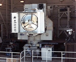
MIRACL, or Mid-Infrared Advanced Chemical Laser, is a directed energy weapon developed by the US Navy. It is a deuterium fluoride laser, a type of chemical laser.

<span class="mw-page-title-main">Samos (satellite)</span> Series of reconnaissance satellites for the United States

The SAMOS or SAMOS-E program was a relatively short-lived series of reconnaissance satellites for the United States in the early 1960s, also used as a cover for the initial development of the KH-7 GAMBIT system. Reconnaissance was performed with film cameras and television surveillance from polar low Earth orbits with film canister returns and transmittals over the United States. SAMOS was first launched in 1960 from Vandenberg Air Force Base.

Pegasus is an air-launched launch vehicle developed by Orbital Sciences Corporation (OSC) and now built and launched by Northrop Grumman. Pegasus is the world's first privately developed orbital launch vehicle. Capable of carrying small payloads of up to 443 kg (977 lb) into low Earth orbit, Pegasus first flew in 1990 and remains active as of 2021. The vehicle consists of three solid propellant stages and an optional monopropellant fourth stage. Pegasus is released from its carrier aircraft at approximately 12,000 m (39,000 ft), and its first stage has a wing and a tail to provide lift and attitude control while in the atmosphere. Notably, the first stage does not have a thrust vector control (TVC) system.

<span class="mw-page-title-main">Defense Support Program</span> US infrared satellite early warning system

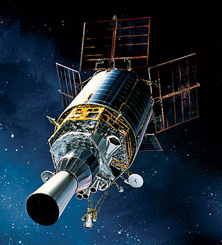
The Defense Support Program (DSP) is a program of the United States Space Force that operated the reconnaissance satellites which form the principal component of the Satellite Early Warning System used by the United States.

<span class="mw-page-title-main">Deep Space Climate Observatory</span> American solar research spacecraft

Deep Space Climate Observatory is a National Oceanic and Atmospheric Administration (NOAA) space weather, space climate, and Earth observation satellite. It was launched by SpaceX on a Falcon 9 v1.1 launch vehicle on 11 February 2015, from Cape Canaveral. This is NOAA's first operational deep space satellite and became its primary system of warning Earth in the event of solar magnetic storms.

Lockheed Martin Space is one of the four major business divisions of Lockheed Martin. It has its headquarters in Littleton, Colorado, with additional sites in Valley Forge, Pennsylvania; Sunnyvale, California; Santa Cruz, California; Huntsville, Alabama; and elsewhere in the United States and United Kingdom. The division currently employs about 20,000 people, and its most notable products are commercial and military satellites, space probes, missile defense systems, NASA's Orion spacecraft, and the Space Shuttle external tank.

<span class="mw-page-title-main">Scout (rocket family)</span> Family of American rockets

The Scout family of rockets were American launch vehicles designed to place small satellites into orbit around the Earth. The Scout multistage rocket was the first orbital launch vehicle to be entirely composed of solid fuel stages. It was also the only vehicle of that type until the successful launch of the Japanese Lambda 4S in 1970.

<span class="mw-page-title-main">Atlas-Agena</span> American expendable launch system

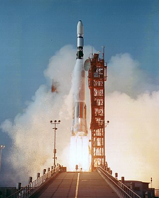
The Atlas-Agena was an American expendable launch system derived from the SM-65 Atlas missile. It was a member of the Atlas family of rockets, and was launched 109 times between 1960 and 1978. It was used to launch the first five Mariner uncrewed probes to the planets Venus and Mars, and the Ranger and Lunar Orbiter uncrewed probes to the Moon. The upper stage was also used as an uncrewed orbital target vehicle for the Gemini crewed spacecraft to practice rendezvous and docking. However, the launch vehicle family was originally developed for the Air Force and most of its launches were classified DoD payloads.

<span class="mw-page-title-main">Space Dynamics Laboratory</span> Nonprofit government contractor owned by Utah State University

Space Dynamics Laboratory (SDL) is a nonprofit government contractor owned by Utah State University. SDL was formed in 1982 from the merger of Utah State University's Electro Dynamics Laboratories and the University of Utah's Upper Air Research Laboratory. The corporation has been responsible for the design, fabrication, and operation of sensors on over 430 payloads ranging from aircraft and rocket-borne experiments to space shuttle experiments and satellite-based sensor systems. SDL is the Missile Defense Agency's University Affiliated Research Center (UARC) and one of 14 UARCs in the nation. SDL provides sensor systems and supporting technologies to address challenges for the United States government. SDL designs and develops electro-optical sensors, builds small satellites, provides calibration services, and creates real-time data reconnaissance systems.

<span class="mw-page-title-main">TacSat-2</span> US military satellite

TacSat-2 is the first in a series of U.S. military experimental technology and communication satellites.TacSat-2 (also known as JWS-D1 was an experimental satellite built by the USAF's Air Force Research Laboratory with an operational life expected to be not more than one year as part of the "Advanced Concept Technology Demonstration" program.

<span class="mw-page-title-main">Missile Defense Alarm System</span> Satellite early warning system

The Missile Defense Alarm System, or MIDAS, was a United States Air Force Air Defense Command system of 12 early-warning satellites that provided limited notice of Soviet intercontinental ballistic missile launches between 1960 and 1966. Originally intended to serve as a complete early-warning system working in conjunction with the Ballistic Missile Early Warning System, cost and reliability concerns limited the project to a research and development role. Three of the system's 12 launches ended in failure, and the remaining nine satellites provided crude infrared early-warning coverage of the Soviet Union until the project was replaced by the Defense Support Program. MiDAS represented one element of the United States's first generation of reconnaissance satellites that also included the Corona and SAMOS series. Though MIDAS failed in its primary role as a system of infrared early-warning satellites, it pioneered the technologies needed in successor systems.

<span class="mw-page-title-main">ARGOS (satellite)</span>

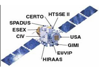
The Advanced Research and Global Observation Satellite (ARGOS) was launched on 23 February 1999 carrying nine payloads for research and development missions by nine separate researchers. The mission terminated on 31 July 2003.

<span class="mw-page-title-main">Guidance, navigation, and control</span> Branch of engineering

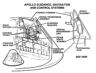
Guidance, navigation and control is a branch of engineering dealing with the design of systems to control the movement of vehicles, especially, automobiles, ships, aircraft, and spacecraft. In many cases these functions can be performed by trained humans. However, because of the speed of, for example, a rocket's dynamics, human reaction time is too slow to control this movement. Therefore, systems—now almost exclusively digital electronic—are used for such control. Even in cases where humans can perform these functions, it is often the case that GNC systems provide benefits such as alleviating operator work load, smoothing turbulence, fuel savings, etc. In addition, sophisticated applications of GNC enable automatic or remote control.

The Near Earth Object Surveillance Satellite (NEOSSat) is a Canadian microsatellite using a 15-cm aperture f/5.88 Maksutov telescope, with 3-axis stabilisation giving a pointing stability of ~2 arcseconds in a ~100 second exposure. It is funded by the Canadian Space Agency (CSA) and Defence Research and Development Canada (DRDC), and searches for interior-to-Earth-orbit (IEO) asteroids, at between 45 and 55 degree solar elongation and +40 to -40 degrees ecliptic latitude.

<span class="mw-page-title-main">Sentinel-3</span> Earth observation satellite series

Sentinel-3 is an Earth observation heavy satellite series developed by the European Space Agency as part of the Copernicus Programme. It currently consists of 2 satellites: Sentinel-3A and Sentinel-3B. After initial commissioning, each satellite was handed over to EUMETSAT for the routine operations phase of the mission. Two recurrent satellites— Sentinel-3C and Sentinel-3D— will follow in approximately 2024 and 2028 respectively to ensure continuity of the Sentinel-3 mission.

SNAP-1 is a British nanosatellite in low Earth orbit. The satellite was built at the Surrey Space Centre by Surrey Satellite Technology Ltd (SSTL) and members of the University of Surrey. It was launched on 28 June 2000 on board a Kosmos-3M rocket from the Plesetsk Cosmodrome in northern Russia. It shared the launch with a Russian Nadezhda search and relay spacecraft and the Chinese Tsinghua-1 microsatellite.

<span class="mw-page-title-main">Suomi NPP</span>

The Suomi National Polar-orbiting Partnership, previously known as the National Polar-orbiting Operational Environmental Satellite System Preparatory Project (NPP) and NPP-Bridge, is a weather satellite operated by the United States National Oceanic and Atmospheric Administration (NOAA). It was launched in 2011 and is currently in operation.

<span class="mw-page-title-main">USA-282</span> United States military satellite

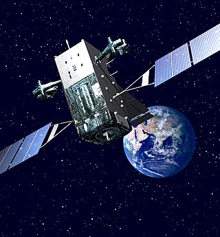
USA-282, also known as SBIRS GEO-4, is a United States military satellite and part of the Space-Based Infrared System.

References

  1. 1 2 Krebs, Gunter. "MSTI 3". Gunter's Space Page. Retrieved 30 March 2017.
  2. 1 2 3 4 5 6 7 8 9 10 11 12 13 14 15 16 17 "Fact Sheet: Miniature Sensor Technology Integration-3". U.S. Air Force. May 1996. Retrieved 30 March 2017.
  3. 1 2 3 4 5 6 7 8 9 10 11 12 13 Rahman, Lesley; Diamond, Preston; Probert, Todd (1998). Lessons Learned from the Miniature Sensor Technology Integration (MSTI) -3 Controlled Reentry. 12th Annual AIAA/USU Conference on Small Satellites. September 1998. Logan, Utah. SSC98-X-3.
  4. 1 2 3 4 5 6 7 "MSTI". Encyclopedia Astronautica. Archived from the original on December 27, 2016. Retrieved 30 March 2017.
  5. DelSignore, Chet R. (16 January 1998). "MSTI-3 satellite mission comes to a close". Astro News. Los Angeles Air Force Base. Archived from the original on 18 November 2000.
  6. 1 2 Horton, Richard F.; Baker, William G.; Griggs, Michael; et al. (June 1995). Bely, Pierre Y.; Breckinridge, James B. (eds.). "MSTI-3 sensor package optical design". Future Space Missions II: Space Telescopes and Instruments, Proceedings of the SPIE. Space Telescopes and Instruments. 2478: 53–74. Bibcode:1995SPIE.2478...53H. doi:10.1117/12.210913. S2CID   122607699.
  7. Bussinger, S. D.; et al. (24 September 1993). Spacecraft Erasable Disk Mass Memory (EDMM). 7th Annual AIAA/USU Conference on Small Satellites. September 1993. Logan, Utah.
  8. Klein, Patricia; Probert, Todd (1995). The Open Architecture Approach to Mission Operations: DMOC to MPOC - A Success Story. 9th Annual AIAA/USU Conference on Small Satellites. September 1995. Logan, Utah.
  9. Weldy, Michelle; Heamey, Steve; Probert, Todd (1997). Miniature Sensor Technology Integration Satellite: A Team's Success. 11th Annual AIAA/USU Conference on Small Satellites. September 1997. Logan, Utah. SSC97-IV-4.
  10. 1 2 3 4 5 6 Jeffrey, William; Fraser, James; Schneider, Garret (1994). MSTI-3 Science Objectives. 8th Annual AIAA/USU Conference on Small Satellites. August 1994. Logan, Utah.
  11. 1 2 "MSTI 3 - Details". National Space Science Data Center . NASA. Retrieved 1 April 2017.
  12. 1 2 3 "Pegasus launches MSTI 3 for USAF". Flight International. 29 May 1996. Retrieved 1 April 2017.
  13. Bull, Leona C. (11 December 1997). "MIRACL damaged in experiment". Aerotech News and Review : 1. ISSN   1094-7302. OCLC   56975066. Archived from the original on 5 August 2003. Retrieved 30 September 2022. The Mid-Infrared Chemical Laser was slightly damaged twice during tests against the Air Force's Miniature Sensor Technology Integration (MSTI-3) satellite in October. The purpose of the tests was to evaluate the effect of the laser on the satellite's infrared sensors. [...] Program experts believe that when the power was ramped up, a shock wave in the gases within the deuterium fluoride laser resulted, and caused it to move, which then caused a small amount of melting inside the device.
  14. "PENTAGON/LASER TEST". Voice of America News. 23 October 1997. Retrieved 1 March 2018.