Miramiguoa Park, Missouri

Last updated
Miramiguoa Park, Missouri
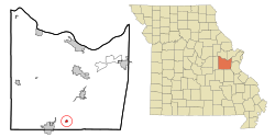
Franklin County Missouri Incorporated and Unincorporated areas Miramiguoa Park Highlighted.svg
Location of Miramiguoa Park, Missouri
Coordinates: 38°14′17″N91°4′9″W / 38.23806°N 91.06917°W / 38.23806; -91.06917 Coordinates: 38°14′17″N91°4′9″W / 38.23806°N 91.06917°W / 38.23806; -91.06917
Country United States
State Missouri
County Franklin
Area
[1]
  Total0.39 sq mi (1.00 km2)
  Land0.39 sq mi (1.00 km2)
  Water0.00 sq mi (0.00 km2)
Elevation
636 ft (194 m)
Population
 (2020)
  Total126
  Density327.27/sq mi (126.36/km2)
Time zone UTC-6 (Central (CST))
  Summer (DST) UTC-5 (CDT)
FIPS code 29-48880 [2]
GNIS feature ID1759738 [3]

Miramiguoa Park is a village in Franklin County, Missouri, United States. The population was 120 at the 2010 census.

Contents

Geography

Miramiguoa Park is located at 38°14′17″N91°4′9″W / 38.23806°N 91.06917°W / 38.23806; -91.06917 (38.238038, -91.069297). [4]

According to the United States Census Bureau, the village has a total area of 0.39 square miles (1.01 km2), all land. [5]

Demographics

Historical population
CensusPop.
2000 127
2010 120−5.5%
2020 1265.0%
U.S. Decennial Census [6]

2010 census

As of the census [7] of 2010, there were 120 people, 50 households, and 32 families living in the village. The population density was 307.7 inhabitants per square mile (118.8/km2). There were 68 housing units at an average density of 174.4 per square mile (67.3/km2). The racial makeup of the village was 98.3% White, 0.8% from other races, and 0.8% from two or more races. Hispanic or Latino of any race were 1.7% of the population.

There were 50 households, of which 24.0% had children under the age of 18 living with them, 46.0% were married couples living together, 12.0% had a female householder with no husband present, 6.0% had a male householder with no wife present, and 36.0% were non-families. 34.0% of all households were made up of individuals, and 12% had someone living alone who was 65 years of age or older. The average household size was 2.40 and the average family size was 3.00.

The median age in the village was 45 years. 21.7% of residents were under the age of 18; 7.6% were between the ages of 18 and 24; 20.9% were from 25 to 44; 35.8% were from 45 to 64; and 14.2% were 65 years of age or older. The gender makeup of the village was 45.8% male and 54.2% female.

2000 census

As of the census [2] of 2000, there were 127 people, 47 households, and 32 families living in the village. The population density was 329.8 inhabitants per square mile (127.3/km2). There were 63 housing units at an average density of 163.6 per square mile (63.2/km2). The racial makeup of the village was 96.85% White, 0.79% Asian, 1.57% from other races, and 0.79% from two or more races. Hispanic or Latino of any race were 1.57% of the population.

There were 47 households, out of which 31.9% had children under the age of 18 living with them, 46.8% were married couples living together, 12.8% had a female householder with no husband present, and 29.8% were non-families. 23.4% of all households were made up of individuals, and 6.4% had someone living alone who was 65 years of age or older. The average household size was 2.70 and the average family size was 3.18.

In the village, the population was spread out, with 30.7% under the age of 18, 7.1% from 18 to 24, 29.1% from 25 to 44, 21.3% from 45 to 64, and 11.8% who were 65 years of age or older. The median age was 34 years. For every 100 females, there were 111.7 males. For every 100 females age 18 and over, there were 104.7 males.

The median income for a household in the village was $28,750, and the median income for a family was $43,750. Males had a median income of $31,000 versus $25,833 for females. The per capita income for the village was $12,141. There were 10.0% of families and 21.4% of the population living below the poverty line, including 30.0% of under eighteens and none of those over 64.
Related Research Articles

<span class="mw-page-title-main">Westview, Florida</span> CDP in Florida, United States

Westview is a census-designated place (CDP) in Miami-Dade County, Florida, United States. The population was 9,923 at the 2020 census.

<span class="mw-page-title-main">Graettinger, Iowa</span> City in Iowa, United States

Graettinger is a city in Palo Alto County, Iowa, United States. The population was 832 at the time of the 2020 census.

<span class="mw-page-title-main">Dayton, Iowa</span> City in Iowa, United States

Dayton is a city in Webster County, Iowa, United States. The population was 772 at the time of the 2020 census.

<span class="mw-page-title-main">Harwich Port, Massachusetts</span> Census-designated place in Massachusetts, United States

Harwich Port is a small seaside community and census-designated place (CDP) situated along Nantucket Sound in the town of Harwich in Barnstable County, Massachusetts, United States. It is named after the port of Harwich in Essex, England. As of the 2010 census, the CDP had a population of 1,644. It is a popular vacation spot on Cape Cod and is home to the Wychmere Beach Club and the Allen Harbor Yacht Club. Also, one of its popular mottos is "Three Harbors, One Port", referencing to Saquatucket, Wychmere, and Allen Harbor, which are all located in Harwich Port. Well known residents include Bill O'Brien, head coach and general manager of the Houston Texans.

<span class="mw-page-title-main">Rothbury, Michigan</span> Village in Michigan, United States

Rothbury is a village in Grant Township, Oceana County in the U.S. state of Michigan. The population was 486 at the 2010 census.

<span class="mw-page-title-main">Shiawassee Township, Michigan</span> Civil township in Michigan, United States

Shiawassee Township is a civil township of Shiawassee County in the U.S. state of Michigan. The population was 2,840 at the 2010 census.

<span class="mw-page-title-main">Cedar Hill Lakes, Missouri</span> Village in Missouri, United States

Cedar Hill Lakes is a village in Jefferson County, Missouri, United States. The population was 237 at the 2010 census.

<span class="mw-page-title-main">Westwood, Missouri</span> Village in Missouri, United States

Westwood is a village in west St. Louis County, Missouri, United States. The population was 278 at the 2010 census.

<span class="mw-page-title-main">San Juan, New Mexico</span> CDP in New Mexico, United States

San Juan is a census-designated place (CDP) in Rio Arriba County, New Mexico, United States. The population was 592 at the 2000 census.

<span class="mw-page-title-main">Cuyahoga Heights, Ohio</span> Village in Ohio, United States

Cuyahoga Heights is a village in Cuyahoga County, Ohio, United States. The population was 638 at the 2010 census.

<span class="mw-page-title-main">Addyston, Ohio</span> Village in Ohio, United States

Addyston is a village in Miami Township, Hamilton County, Ohio, United States, along the Ohio River. The population was 938 at the 2010 census.

<span class="mw-page-title-main">Lane, South Dakota</span> Town in South Dakota, United States

Lane is a town in Jerauld County, South Dakota, United States. The population was 59 at the 2010 census.

<span class="mw-page-title-main">Bethlehem, West Virginia</span> Village in West Virginia, United States

Bethlehem is a village in Ohio County, West Virginia, United States. It is part of the Wheeling, West Virginia Metropolitan Statistical Area. The population was 2,499 at the 2010 census.

<span class="mw-page-title-main">Kekoskee, Wisconsin</span> Village in Wisconsin, United States

Kekoskee is a village in Dodge County, Wisconsin, United States. The population was 161 at the 2010 census.

<span class="mw-page-title-main">Avoca, Wisconsin</span> Village in Wisconsin, United States

Avoca is a village in Iowa County, Wisconsin, United States. The population was 637 at the 2010 census. It is part of the Madison Metropolitan Statistical Area. It is named after Avoca in Ireland.

<span class="mw-page-title-main">Spring Lake Park, Minnesota</span> City in Minnesota, United States

Spring Lake Park is a city in Anoka and Ramsey counties in the state of Minnesota. The population was 6,412 at the 2010 census. The city is located mainly within Anoka County. Minnesota State Highways 47 and 65 and County Highway 10 are three of the main routes in the city.

<span class="mw-page-title-main">Verona, Ohio</span> Village in Ohio, United States

Verona is a village in Montgomery and Preble counties in the U.S. state of Ohio. The population was 494 at the 2010 census. It is part of the Dayton Metropolitan Statistical Area.

<span class="mw-page-title-main">New Hartford (village), New York</span> Village in New York, United States

New Hartford is a village in Oneida County, New York, United States. The population was 1,847 at the 2010 census. The name was provided by early settlers from New Hartford, Connecticut.

<span class="mw-page-title-main">Superior (village), Wisconsin</span> Village in Wisconsin, United States

The Village of Superior is a village in Douglas County, Wisconsin, United States. The population was 664 at the 2010 census. The village is located within the Town of Superior and is located immediately south of and adjacent to the City of Superior.

<span class="mw-page-title-main">Bloomington, Wisconsin</span> Village in Wisconsin, United States

Bloomington is a village in Grant County, Wisconsin, United States. The population was 735 as of the 2010 census. The village is located within the Town of Bloomington.

References

  1. "ArcGIS REST Services Directory". United States Census Bureau. Retrieved August 28, 2022.
  2. 1 2 "U.S. Census website". United States Census Bureau . Retrieved 2008-01-31.
  3. "US Board on Geographic Names". United States Geological Survey. 2007-10-25. Retrieved 2008-01-31.
  4. "US Gazetteer files: 2010, 2000, and 1990". United States Census Bureau. 2011-02-12. Retrieved 2011-04-23.
  5. "US Gazetteer files 2010". United States Census Bureau. Archived from the original on 2011-02-20. Retrieved 2012-07-08.
  6. "Census of Population and Housing". Census.gov. Retrieved June 4, 2015.
  7. "U.S. Census website". United States Census Bureau . Retrieved 2012-07-08.