Oak Grove Village, Missouri

Last updated

Oak Grove Village, Missouri
Franklin County Missouri Incorporated and Unincorporated areas Oak Grove Highlighted.svg
Location of Oak Grove Village, Missouri
Coordinates: 38°13′40″N91°08′58″W / 38.22778°N 91.14944°W / 38.22778; -91.14944
Country United States
State Missouri
County Franklin
Area
[1]
  Total0.61 sq mi (1.59 km2)
  Land0.61 sq mi (1.59 km2)
  Water0.00 sq mi (0.00 km2)
Elevation
[2]
938 ft (286 m)
Population
 (2020)
  Total412
  Density669.92/sq mi (258.65/km2)
Time zone UTC-6 (Central (CST))
  Summer (DST) UTC-5 (CDT)
ZIP code
63080 [3]
Area code 573
FIPS code 29-53606 [4]
GNIS feature ID2399535 [2]

Oak Grove Village is a village in Franklin County, Missouri, United States. The population was 509 at the 2010 census.

Contents

Geography

According to the United States Census Bureau, the village has a total area of 0.64 square miles (1.66 km2), all land. [5] [6]

Demographics

Historical population
CensusPop.Note
1970 340
1980 38613.5%
1990 4024.1%
2000 382−5.0%
2010 50933.2%
2020 412−19.1%
U.S. Decennial Census [7]
Two water towers in Oak Grove Village Oak Grove Village.png
Two water towers in Oak Grove Village

2010 census

As of the census [8] of 2010, there were 509 people, 216 households, and 114 families living in the village. The population density was 795.3 inhabitants per square mile (307.1/km2). There were 243 housing units at an average density of 379.7 per square mile (146.6/km2). The racial makeup of the village was 96.5% White, 0.4% African American, 0.4% Native American, 0.2% Asian, 0.2% from other races, and 2.4% from two or more races. Hispanic or Latino of any race were 1.8% of the population.

There were 216 households, of which 31.0% had children under the age of 18 living with them, 30.1% were married couples living together, 16.2% had a female householder with no husband present, 6.5% had a male householder with no wife present, and 47.2% were non-families. 39.8% of all households were made up of individuals, and 20.9% had someone living alone who was 65 years of age or older. The average household size was 2.36 and the average family size was 3.14.

The median age in the village was 33.6 years. 25.3% of residents were under the age of 18; 9.5% were between the ages of 18 and 24; 27.1% were from 25 to 44; 23.8% were from 45 to 64; and 14.3% were 65 years of age or older. The gender makeup of the village was 47.9% male and 52.1% female.

2000 census

As of the census [4] of 2000, there were 382 people, 142 households, and 101 families living in the village. The population density was 727.5 inhabitants per square mile (280.9/km2). There were 162 housing units at an average density of 308.5 per square mile (119.1/km2). The racial makeup of the village was 97.91% White, 0.26% Native American, 0.52% Asian, and 1.31% from two or more races. Hispanic or Latino of any race were 1.05% of the population.

There were 142 households, out of which 36.6% had children under the age of 18 living with them, 52.1% were married couples living together, 10.6% had a female householder with no husband present, and 28.2% were non-families. 23.9% of all households were made up of individuals, and 12.0% had someone living alone who was 65 years of age or older. The average household size was 2.69 and the average family size was 3.09.

In the village, the population was spread out, with 28.5% under the age of 18, 10.5% from 18 to 24, 28.8% from 25 to 44, 20.4% from 45 to 64, and 11.8% who were 65 years of age or older. The median age was 33 years. For every 100 females, there were 94.9 males. For every 100 females age 18 and over, there were 95.0 males.

The median income for a household in the village was $35,357, and the median income for a family was $47,500. Males had a median income of $27,813 versus $18,125 for females. The per capita income for the village was $15,390. About 10.6% of families and 13.4% of the population were below the poverty line, including 16.9% of those under age 18 and 16.4% of those age 65 or over.

Related Research Articles

<span class="mw-page-title-main">Miramiguoa Park, Missouri</span> Village in Missouri, United States

Miramiguoa Park is a village in Franklin County, Missouri, United States. The population was 120 at the 2010 census.
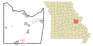
<span class="mw-page-title-main">Pasadena Park, Missouri</span> Village in Missouri, United States

Pasadena Park is a village in St. Louis County, Missouri, United States. The population was 470 at the 2010 census. It is part of the Normandy School District, and is distinct from the city of Pasadena Hills.

<span class="mw-page-title-main">Westwood, Missouri</span> Village in Missouri, United States

Westwood is a village in west St. Louis County, Missouri, United States. The population was 316 at the 2020 census.

<span class="mw-page-title-main">Wilbur Park, Missouri</span> Village in Missouri, United States

Wilbur Park is a village in St. Louis County, Missouri, United States. The population was 439 at the 2020 census.

<span class="mw-page-title-main">Baldwin Park, Missouri</span> Village in Missouri, United States

Baldwin Park is a village in Cass County, Missouri, United States. The population was 92 at the 2010 census. It is part of the Kansas City metropolitan area.

<span class="mw-page-title-main">Hanley Hills, Missouri</span> Village in Missouri, United States

Hanley Hills is a village in St. Louis County, Missouri, United States. The population was 2,101 at the 2010 census.

<span class="mw-page-title-main">Walton Hills, Ohio</span> Village in Ohio, United States

Walton Hills is a village in Cuyahoga County, Ohio, United States. The population was 2,033 at the 2020 census. A suburb of Cleveland, it is a part of the Cleveland metropolitan area.

<span class="mw-page-title-main">Addyston, Ohio</span> Village in Ohio, United States

Addyston is a village in Miami Township, Hamilton County, Ohio, United States. Located along the Ohio River, it is a western suburb of the neighboring city of Cincinnati. The population was 927 at the 2020 census.

<span class="mw-page-title-main">Evendale, Ohio</span> Village in Ohio, United States

Evendale is a village in Hamilton County, Ohio, United States, within the Cincinnati metropolitan area. The population was 2,669 at the 2020 census.

<span class="mw-page-title-main">Golf Manor, Ohio</span> Village in Ohio, United States

Golf Manor is a village in Hamilton County, Ohio, United States. It is almost completely surrounded by the Pleasant Ridge and Roselawn neighborhoods of Cincinnati. The population was 3,814 at the 2020 census.

<span class="mw-page-title-main">Woodlawn, Ohio</span> Village in Ohio, United States

Woodlawn is a village in Hamilton County, Ohio, United States. The population was 3,916 at the 2020 census.

<span class="mw-page-title-main">Elgin, Ohio</span> Village in Ohio, United States

Elgin is a village in Van Wert County, Ohio, United States. The population was 49 at the 2020 census. It is included within the Van Wert, Ohio Micropolitan Statistical Area.

<span class="mw-page-title-main">Friesland, Wisconsin</span> Village in Wisconsin, United States

Friesland is a village in Columbia County, Wisconsin, United States. The population was 320 at the 2020 census. It is part of the Madison Metropolitan Statistical Area, and was named after Friesland, one of the twelve provinces of the Netherlands.

<span class="mw-page-title-main">Kekoskee, Wisconsin</span> Village in Wisconsin, United States

Kekoskee is a village in Dodge County, Wisconsin, United States. The population was 161 at the 2010 census.

<span class="mw-page-title-main">Nelsonville, Wisconsin</span> Village in Wisconsin, United States

Nelsonville is a village in Portage County, Wisconsin, United States. The population was 155 at the 2010 census.

<span class="mw-page-title-main">Wilson, Ohio</span> Village in Ohio, United States

Wilson is a village in Belmont and Monroe counties in the U.S. state of Ohio. The population was 129 at the 2020 census. It is part of the Wheeling metropolitan area.

<span class="mw-page-title-main">Verona, Ohio</span> Village in Ohio, United States

Verona is a village in Montgomery and Preble counties in the U.S. state of Ohio. The population was 403 at the 2020 census. It is part of the Dayton Metropolitan Statistical Area.

<span class="mw-page-title-main">Dallas, Wisconsin</span> Village in Wisconsin, United States

Dallas is a village in Barron County in the U.S. state of Wisconsin. The population was 409 at the 2010 census. The village is located within the Town of Dallas.

<span class="mw-page-title-main">Lowell, Wisconsin</span> Village in Wisconsin, United States

Lowell is a village in Dodge County, Wisconsin, United States, along the Beaver Dam River. The population was 340 at the 2010 census. The village is located within the Town of Lowell.

<span class="mw-page-title-main">Aniwa, Wisconsin</span> Village in Wisconsin, United States

Aniwa is a village in Shawano County, Wisconsin, United States. The population was 260 at the 2010 census. The village is located within the Town of Aniwa. U.S. Route 45 runs north–south through the village.

References

  1. "ArcGIS REST Services Directory". United States Census Bureau. Retrieved August 28, 2022.
  2. 1 2 U.S. Geological Survey Geographic Names Information System: Oak Grove Village, Missouri
  3. "Oak Grove Village MO ZIP Code". zipdatamaps.com. 2023. Retrieved June 16, 2023.
  4. 1 2 "U.S. Census website". United States Census Bureau . Retrieved January 31, 2008.
  5. "US Gazetteer files 2010". United States Census Bureau. Archived from the original on January 12, 2012. Retrieved July 8, 2012.
  6. "US Gazetteer files: 2010, 2000, and 1990". United States Census Bureau. February 12, 2011. Retrieved April 23, 2011.
  7. "Census of Population and Housing". Census.gov. Retrieved June 4, 2015.
  8. "U.S. Census website". United States Census Bureau . Retrieved July 8, 2012.