Miyaki, Saga

Last updated • 2 min readFrom Wikipedia, The Free Encyclopedia
Miyaki
みやき町
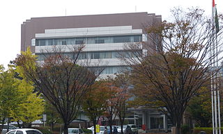
Nakabaru Branch of Miyaki Town Hall 20170216-3.jpg
Nakabaru Branch of Miyaki Town Hall
Flag of Miyaki, Saga.svg
Emblem of Miyaki, Saga.svg
Miyaki, Saga
Location of Miyaki in Saga Prefecture
Miyaki in Saga Prefecture Ja.svg
Japan location map with side map of the Ryukyu Islands.svg
Red pog.svg
Miyaki
Location in Japan
Coordinates: 33°19′30″N130°27′17″E / 33.32500°N 130.45472°E / 33.32500; 130.45472
CountryJapan
Region Kyushu
Prefecture Saga
District Miyaki
Area
  Total51.92 km2 (20.05 sq mi)
Population
 (April 30, 2024)
  Total25,745
  Density500/km2 (1,300/sq mi)
Time zone UTC+09:00 (JST)
City hall address737-5 Higashio, Miyaki-chō, Miyaki-gun, Saga-ken 849-0113
Website Official website
Symbols
Flower Cosmos
Tree Sakura
Chiriku Hachiman Shrine Haiden of Chiriku Hachiman Shrine 2.jpg
Chiriku Hachiman Shrine

Miyaki (みやき町, Miyaki-chō) is a town in Miyaki District, Saga Prefecture, Japan. [1] [2] As of 30 April 2024, the town had an estimated population of 25,745 in 10599 households, and a population density of 500 people per km2. [3] The total area of the town is 51.92 km2 (20.05 sq mi). It is the first town in Saga to have its name spelled in hiragana rather than kanji . It is named after the district it is located in.

Contents

Geography

Miyaki is located in the eastern part of Saga Prefecture, about 20 kilometres (12 mi) east of Saga City and about 30 kilometres (19 mi) south of Fukuoka. The northern part of Miyaki contains the Chikushi Mountains, and the southern part contains the Chikugo River. It borders Fukuoka Prefecture on the north and south.

Adjoining municipalities

Fukuoka Prefecture

Saga Prefecture

Climate

Miyaki has a humid subtropical climate (Köppen Cfa) characterized by warm summers and cool winters with light to no snowfall. The average annual temperature in Miyaki is 15.7 °C. The average annual rainfall is 1946 mm with September as the wettest month. The temperatures are highest on average in August, at around 26.5 °C, and lowest in January, at around 5.1 °C. [4]

Demographics

Per Japanese census data, the population of Miyaki is as shown below. [5]

Historical population
YearPop.±%
1940 19,804    
1950 26,807+35.4%
1960 25,384−5.3%
1970 24,754−2.5%
1980 27,757+12.1%
1990 28,702+3.4%
2000 28,625−0.3%
2010 26,175−8.6%
2020 25,511−2.5%

History

The area of Miyaki was part of ancient Hizen Province. During the Edo Period, it was mostly part of the holdings of Saga Domain. Following the Meiji restoration, the villages of Nakabaru, Kitashigeyasu, Minamishigeyasu, and Mikawa were established with the creation of the modern municipalities system on April 1, 1889. On April 1, 1955 the villages Minamishigeyasu and Nakabaru merged to form Mine Village, which was raised to town status on May 5, 1962. Kitashigeyasu Village was raised to town status on April 1, 1965, followed by Nakabaru on April 1, 1971. On March 1, 2005 the towns of Mine, Kitashigeyasu and Nakabaru merged to form the town of Miyaki.

Government

Miyaki has a mayor-council form of government with a directly elected mayor and a unicameral town council of 16 members. Miyaki, collectively with the other municipalities of Miyaki District, contributes two members to the Saga Prefectural Assembly. In terms of national politics, the city is part of the Saga 1st district of the lower house of the Diet of Japan.

Economy

The economy of Miyaki is overwhelmingly based on agriculture, mostly rice production.

Education

Miyaki has four public elementary schools and three public junior high schools by the town government, and one public high school operated by the Fukuoka Prefectural Board of Education. The prefecture also operates a special education school for the handicapped.

Transportation

Railways

JR logo (west).svg JR Kyushu - Nagasaki Main Line

JH Nakabaru

Highways

Local attractions

Related Research Articles

<span class="mw-page-title-main">Ōkawa, Fukuoka</span> City in Kyushu, Japan

Ōkawa is a city located in Fukuoka Prefecture, Japan. As of 1 February 2024, the city had an estimated population of 31,605 in 13984 households, and a population density of 940 persons per km². The total area of the city is 33.62 km2 (12.98 sq mi).
<span class="mw-page-title-main">Kasuga, Fukuoka</span> City in Kyushu, Japan

Kasuga is a city located in Fukuoka Prefecture, Japan. As of 31 March 2024, the city had an estimated population of 111,840 in 50874 households, and a population density of 260 persons per km². The total area of the city is 14.145 km2 (5.461 sq mi).

<span class="mw-page-title-main">Kashima, Saga</span> City in Kyushu, Japan

Kashima is a city located in the southern part of Saga Prefecture on the island of Kyushu, Japan. As of 31 May 2024, the city had an estimated population of 27,360 in 10949 households, and a population density of 240 persons per km2. The total area of the city is 112.12 km2 (43.29 sq mi).

<span class="mw-page-title-main">Kanzaki, Saga</span> City in Kyushu, Japan

Kanzaki is a city located in Saga Prefecture, Japan. As of 30 April 2024, the city had an estimated population of 30,329 in 12,440 households, and a population density of 240 persons per km2. The total area of the city is 125.13 km2 (48.31 sq mi).

<span class="mw-page-title-main">Kiyama, Saga</span> Town in Kyushu, Japan

Kiyama is a town located in Miyaki District, Saga Prefecture, Japan on the island of Kyūshū. As of 31 March 2024, the town had an estimated population of 17,559 in 7508 households, and a population density of 750 persons per km². The total area of the town is 22.15 km2 (8.55 sq mi)

Nakabaru was a town located in Miyaki District, Saga Prefecture, Japan. The status of Nakabaru was changed from a village to a town on April 1, 1971.

Kitashigeyasu was a town located in Miyaki District, Saga Prefecture, Japan. It was established as a village and was later upgraded to a town on April 1, 1965.

Mine was a town located in Miyaki District, Saga Prefecture, Japan. The status of this municipality was changed from a village to a town on May 1, 1962.

<span class="mw-page-title-main">Kamimine, Saga</span> Town in Kyushu, Japan

Kamimine is a town located in Miyaki District, Saga Prefecture, Japan. As of 30 April 2024, the town had an estimated population of 9806 in 3954 households, and a population density of 770 people per km2. The total area of the town is 12.80 km2 (4.94 sq mi).

<span class="mw-page-title-main">Shiroishi, Saga</span> Town in Kyushu, Japan

Shiroishi is a town located in south-central Saga Prefecture, Japan, in Kishima District. It is known for its vast reclaimed land and tidal flats of the Ariake Sea.As of 31 May 2024, the town had an estimated population of 20,790, and a population density of 210 persons per km². The total area of the town is 99.56 km2 (38.44 sq mi)

<span class="mw-page-title-main">Tara, Saga</span> Town in Kyushu, Japan

Tara is a town and peninsula located in Fujitsu District, Saga Prefecture, Japan. As of 31 March 2024, the town had an estimated population of 7973 in 3215 households, and a population density of 750 persons per km². The total area of the town is 74.30 km2 (28.69 sq mi)

<span class="mw-page-title-main">Nakagawa, Fukuoka</span> City in Kyushu, Japan

Nakagawa is a city located in Fukuoka Prefecture, Japan. The city was founded on October 1, 2018, making it the newest city in Japan. As of 31 March 2024, the city had an estimated population of 49,400 in 21613 households, and a population density of 660 persons per km². The total area is 74.95 km2 (28.94 sq mi).

<span class="mw-page-title-main">Anamizu, Ishikawa</span> Town in Ishikawa, Japan

Anamizu is a town located in Hōsu District, Ishikawa Prefecture, Japan. As of 30 September 2021, the town had an estimated population of 7,782 in 3,653 households, and a population density of 42 persons per km2. The total area of the town was 183.21 square kilometres (70.74 sq mi).

<span class="mw-page-title-main">Unzen, Nagasaki</span> City in Kyushu, Japan

Unzen is a city located in Nagasaki Prefecture, Japan. As of 30 June 2024, the city had an estimated population of 40,831 in 17709 households, and a population density of 190 people per km2. The total area of the town is 214.31 km2 (82.75 sq mi).

<span class="mw-page-title-main">Nakabaru Station</span> Railway station in Miyaki, Saga Prefecture, Japan

Nakabaru Station is a passenger railway station located in the town of Miyaki, Miyaki District, Saga Prefecture, Japan. It is operated by JR Kyushu and is on the Nagasaki Main Line.

<span class="mw-page-title-main">Yoshinogari, Saga</span> Town in Kyushu, Japan

Yoshinogari is a town located in Kanzaki District, Saga Prefecture, Japan. As of 30 April 2024, the town had an estimated population of 16,161 in 6,792 households, and a population density of 370 people per km2. The total area of the town is 43.99 km2 (16.98 sq mi).

<span class="mw-page-title-main">Ōmachi, Saga</span> Town in Kyushu, Japan

Ōmachi is a town located in Kishima District, Saga Prefecture, Japan. As of 31 May 2024, the town had an estimated population of 5,960 in 2646 households, and a population density of 520 persons per km². The total area of the town is 11.50 km2 (4.44 sq mi)

<span class="mw-page-title-main">Kōhoku, Saga</span> Town in Kyushu, Japan

Kōhoku is a town located in Kishima District, Saga Prefecture, Japan. It is known as a crossroads for railways and national highways, and as such has dubbed itself "the navel of Saga". As of 31 May 2024, the town had an estimated population of 9586 in 3715 households, and a population density of 750 persons per km². The total area of the town is 24.88 km2 (9.61 sq mi)

<span class="mw-page-title-main">Itoshima, Fukuoka</span> City in Kyushu, Japan

Itoshima is a city located in western Fukuoka Prefecture, Japan. As of 31 March 2024, the city had an estimated population of 103,655 in 46,192 households, and a population density of 480 persons per km². The total area of the city is 215.69 km2 (83.28 sq mi).

<span class="mw-page-title-main">Nishi Kyushu Shinkansen</span> High-speed railway line in Japan

The Nishi Kyushu Shinkansen is a Japanese Shinkansen high-speed rail line on the northwest part of Kyushu Island that is operated by the Kyushu Railway Company. A segment of the line that connects Nagasaki to Takeo-Onsen commenced service on 23 September 2022. The line runs parallel to the existing Nagasaki Main Line and has a total length of 66 kilometers (41 mi), making it the shortest high-speed Shinkansen railway line in Japan in terms of length.

References

  1. "佐賀県に初出店!NYスタイルのドーナツを展開する『 ROOTH』フランチャイズ店が佐賀県みやき町にオープン!数量限定「佐賀のお米」を使用したドーナツも発売!". プレスリリース・ニュースリリース配信シェアNo.1|PR TIMES. Retrieved 2022-10-21.
  2. "みやき町が「子ども第三の居場所」 生活や学びを支援". 西日本新聞me (in Japanese). Retrieved 2022-10-21.
  3. "Miyaki Town official statistics" (in Japanese). Japan.
  4. Miyaki climate: Average Temperature, weather by month
  5. Saga Prefecture population by municipality