
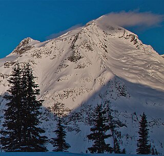
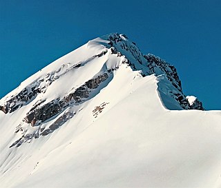
Snowpatch Spire is a mountain peak in British Columbia, Canada. With its first ascent in 1940, it was the last of the Bugaboo Spires to be climbed. It is located southwest of the Conrad Kain hut, between Bugaboo, Vowell and Crescent Glaciers, at the south end of Bugaboo Provincial Park. The mountain's toponym was officially adopted October 29, 1962, by the Geographical Names Board of Canada.
The Battle Range is a subrange of the Selkirk Mountains of the Columbia Mountains in southeastern British Columbia, Canada, located between Incomappleux River and Duncan River south of Battle Brook. It is named in association with Battle Brook which in turn was the site of a legendary battle between a grizzly bear and 1890s prospector George Ritchie.

Avalanche Mountain is a 2,861-metre (9,386-foot) summit in Glacier National Park in the Selkirk Mountains in British Columbia, Canada. Its nearest higher peak is Mount Macdonald, 2.2 km (1.4 mi) to the north. Mount Sir Donald is 3.83 km (2.38 mi) to the southeast, and Eagle Peak is 1.46 km (0.91 mi) to the south-southeast. The Avalanche Glacier is situated on the east side of the peak, and the Connaught Tunnel lies partially beneath Avalanche Mountain. The peak is visible from eastbound Highway 1, the Trans-Canada Highway approaching Rogers Pass. During winter and spring of each year the western slope, named Avalanche Crest, generates avalanches which can threaten the highway.

Youngs Peak is a 2,815-metre (9,236-foot) glaciated mountain summit in Glacier National Park, in the Selkirk Mountains of British Columbia, Canada. It is 12 km (7.5 mi) south of Rogers Pass, 58 km (36 mi) northeast of Revelstoke, and 36 km (22 mi) west of Golden. The mountain was first climbed in 1898 by Charles Ernest Fay and Redt F. Curtis. The mountain's toponym was officially adopted February 8, 1977, by the Geographical Names Board of Canada. It is named for Mrs. Julia M. Young (1853-1925), the Glacier House manager from 1899 through 1920.

Phyllis's Engine is a 2,517-metre (8,258-foot) granite pinnacle located in British Columbia, Canada.

Mount Howard is a 2,551-metre (8,369-foot) mountain summit located in the Coast Mountains of British Columbia, Canada. It is part of the Joffre Group, which is a subset of the Lillooet Ranges. Mount Howard is situated 27 km (17 mi) east of Pemberton and immediately southeast of Mount Matier. Precipitation runoff from the peak drains into Twin One Creek thence Lillooet Lake which is within the Lillooet River watershed. Mount Howard is more notable for its steep rise above local terrain than for its absolute elevation as topographic relief is significant with the summit rising 1,650 meters (5,413 ft) above Twin One Creek in 4 km (2.5 mi).

Anniversary Peak is a 2,947-metre (9,669-foot) summit in The Bugaboos of British Columbia, Canada. It is located southeast of the Bugaboo Glacier, on the southern boundary of Bugaboo Provincial Park. Precipitation runoff from Anniversary Peak drains into Bugaboo Creek which is a tributary of the Columbia River. Anniversary Peak is more notable for its steep rise above local terrain than for its absolute elevation as topographic relief is significant with the summit rising 1,350 meters (4,429 ft) above Bugaboo Creek in 4 km (2.5 mi).
Mount Butters is a 3,141-metre (10,305-foot) mountain summit in British Columbia, Canada.
Omoo Peak is a 2,674-metre (8,773-foot) mountain summit in British Columbia, Canada.

Mount Proteus is a 3,198-metre (10,492-foot) mountain summit in British Columbia, Canada.

Typee Mountain is a 2,897-metre (9,505-foot) summit in British Columbia, Canada.
Pequod Mountain is a 2,979-metre (9,774-foot) summit in British Columbia, Canada.
Nautilus Mountain is a 3,130-metre (10,270-foot) summit in British Columbia, Canada.
Outrigger Peak is a 2,850-metre (9,350-foot) mountain summit in British Columbia, Canada.

Mainmast Peak is a 2,863-metre (9,393-foot) mountain summit in British Columbia, Canada.
Scylla Mountain is a 2,920-metre (9,580-foot) summit in British Columbia, Canada.

Wrong Peak is a 2,869-metre (9,413-foot) summit in British Columbia, Canada.

Mount Nemo is a 2,901-metre (9,518-foot) summit in British Columbia, Canada.
Hall Peak is a 3,048-metre (10,000-foot) mountain summit located in British Columbia, Canada.

Adamant Mountain is a 3,345-metre (10,974-foot) mountain in British Columbia, Canada.


