
Jamtara is a city and a notified area in the Jamtara Sadar subdivision of the Jamtara district in the Indian state of Jharkhand. It is the headquarters of the eponymous district, subdivision and community development block.
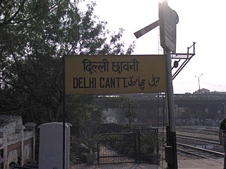
Delhi Cantonment is a Class I Cantonment Board established in 1914. The area of the Cantonment is 10,452 acres (42.30 km2) and the population of the Cantonment as per the 2011 census is 110,351.

Dhanbad district is one of the twenty-four districts of Jharkhand state, India, and Dhanbad is the administrative headquarters of this district. As of 2011, it is the second most populous district of Jharkhand, after Ranchi. It also has the lowest sex ratio in Jharkhand, at 908.

Barpeta is a town in Barpeta district of the state of Assam in India and is district headquarters. The city is located 90 kilometres (56 mi) north west of Guwahati and is one of the major cities in Western Assam. It is also called Satra Nagari of Assam due to the presence of various Vaishnavite Satras in the vicinity.
Chirang District is an administrative district in the Bodoland Territorial Region of Assam state in the North-East of India.
Aminagar Sarai is a town and a nagar panchayat in Baghpat district in the state of Uttar Pradesh, India. It is the oldest town in the Meerut commissionary area.
Bokajan is a town in Karbi Anglong district in the state of Assam, India. Bokajan is best known for its Cement factory. It is 15 km away from Dimapur and partially borders Nagaland.
Gobindpur is a census town in Govindpur CD block in Dhanbad Sadar subdivision of Dhanbad district in the Indian state of Jharkhand.
Kailudih is a neighbourhood in Dhanbad in Dhanbad Sadar subdivision of Dhanbad district in Jharkhand state, India.
Kharkhari is a census town in Baghmara CD block in Dhanbad Sadar subdivision of Dhanbad district in the Indian state of Jharkhand.
Malkera is a census town in Baghmara CD block in Dhanbad Sadar subdivision of Dhanbad district in the Indian state of Jharkhand.

Sainthia is a city and a municipality in Suri Sadar subdivision of Birbhum district in the Indian state of West Bengal. The city is known as business city of Birbhum district. The city is under the jurisdiction of Sainthia police station. Sainthia is the fourth most populous city in Birbhum district and 95th most populous city in West Bengal. The city covers an area of 10 km2 and had a population of 44,601 in 2011. Located on the banks of Mayurakshi River, Sainthia has been a major human settlement. The city is famous for Nandikeshwari Temple, one of the Shakti Peethas in Indian subcontinent.
Sarcarsamakulam, also known as Kovilpalayam, is a western suburb in Coimbatore in the Indian state of Tamil Nadu. This town is located 17 kilometers from Coimbatore Junction and 12 kilometers from Coimbatore International Airport, Tamil Nadu, India, on the Sathyamangalam Road. Neighbouring places are Saravanampatti, Kalapatti, Vilankurichi
Gobindpur is a village located in southern part of Karra block, Khunti district. It is 50 kilometres from Ranchi, the capital of Jharkhand state.
Kerur is a town in Bagalkot district in Karnataka, which located on NH 218. It has an average elevation of 617 meters (2024 feet). It's the birthplace of Jagadish Shettar, a former Chief Minister of Karnataka. Kerur is a Town Panchayat city in the district of Bagalkot, Karnataka. The Kerur city is divided into 16 wards for which elections are held every five years. The Kerur Town Panchayat has a population of 19,731 of which 9,929 are males while 9,802 are females as per report released by Census India 2011.
Venkepally is a medium size village/hamlet in Nuthankal Mandal in Suryapet district of Telangana state, India. It comes under Venkepally Panchayath.It is located 26 km east of the district headquarters of Suryapet and 150 km from the state capital Hyderabad.
Tundi is a community development block that forms an administrative division in Dhanbad Sadar subdivision of Dhanbad district, Jharkhand state, India.
Govindpur is a community development block that forms an administrative division in Dhanbad Sadar subdivision of Dhanbad district, Jharkhand state, India.
Kaviyaloor is a developing town panchayat in the Kanyakumari district in the Indian state of Tamil Nadu approximately 47 kilometres from Thiruvananthapuram.
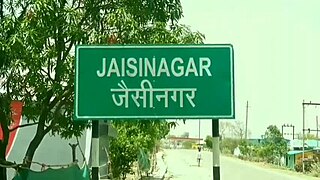
Jaisinagar is a town in Sagar district of Madhya Pradesh. It is a tehsil and Development Block,


