
Ricketts Glen State Park is a Pennsylvania state park on 13,193 acres (5,280 ha) in Columbia, Luzerne, and Sullivan counties in Pennsylvania in the United States. Ricketts Glen is a National Natural Landmark known for its old-growth forest and 24 named waterfalls along Kitchen Creek, which flows down the Allegheny Front escarpment from the Allegheny Plateau to the Ridge-and-Valley Appalachians. The park is near the borough of Benton on Pennsylvania Route 118 and Pennsylvania Route 487, and is in five townships: Sugarloaf in Columbia County, Fairmount and Ross in Luzerne County, and Colley and Davidson in Sullivan County.

Ramapo Mountain State Forest is a 4,200 acres (17 km2) state forest in Bergen and Passaic Counties in New Jersey. The park is operated and maintained by the New Jersey Division of Parks and Forestry.

The Whiskeytown–Shasta–Trinity National Recreation Area is a United States National Recreation Area in northern California. The recreation area was authorized in 1965 by the United States Congress. Recreational activities available include swimming, fishing, boating, camping, and hiking.

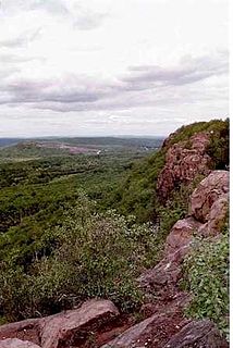
Ragged Mountain, est. 761 feet (232 m), is a traprock mountain ridge located 3 miles (5 km) west of New Britain, Connecticut in the town of Southington and Berlin, Connecticut. It is part of the narrow, linear Metacomet Ridge that extends from Long Island Sound near New Haven, Connecticut, north through the Connecticut River Valley of Massachusetts to the Vermont border. The mountain, a popular hiking and rock climbing attraction located between metropolitan Hartford and Meriden, is known for expansive vistas, vertical cliff faces, mountain ridge reservoirs, unique microclimate ecosystems, and rare plant communities. Ragged Mountain is traversed by the 51-mile (82 km) Metacomet Trail.

Savoy, Mountain State Forest is a remote Massachusetts state forest located primarily in the towns of Savoy and Florida, with portions extending into neighboring Adams and North Adams. Situated along the Hoosac Mountain Range, it features four ponds, and seven hill and mountain summits, including Lewis Hill (2177 ft), Flat Rock Hill (2195 ft), Spruce Hill (2566 ft), and Borden Mountain (2505 ft). Also within the forest are at least two notable waterfalls, Parker Brook Falls and Tannery Falls, the latter of which is a 100-foot (30 m) drop. The forest is managed by the Department of Conservation and Recreation.

Swatara State Park is a 3,515-acre (1,422 ha) Pennsylvania state park in Bethel, Swatara and Union Townships, Lebanon and Pine Grove Township, Schuylkill Counties in Pennsylvania in the United States. 8 miles (13 km) of Swatara Creek lie within the park's boundaries, which are roughly formed by Pennsylvania Route 443 to the north and Interstate 81 to the south. The park is in a valley in the ridge and valley region of Pennsylvania between Second Mountain (north) and Blue Mountain (south).
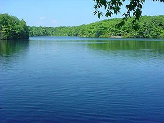
Millers Pond State Park is a public recreation area lying adjacent to Cockaponset State Forest in the towns of Durham and Haddam, Connecticut. The park's central feature is 33-acre (13 ha) Millers Pond, whose principal source of water is large springs that create a body of unpolluted water excellent for trout and smallmouth bass. The park offers fishing, hiking, mountain biking, and hunting.

Wendell State Forest is a Massachusetts state forest located in the town of Wendell. The 7,566-acre (3,062 ha) parcel occupies a forested and hilly upland plateau south of the Millers River and west of the Quabbin Reservoir. Park roads were developed by the Civilian Conservation Corps in the 1930s.
Higby Mountain or Mount Higby 892 feet (272 m), is a traprock mountain ridge located 3.75 miles (6.04 km) east of Meriden, Connecticut. It is part of the narrow, linear Metacomet Ridge that extends from Long Island Sound near New Haven, Connecticut, north through the Connecticut River Valley of Massachusetts to the Vermont border. Higby Mountain is known for its high cliff faces, unique microclimate ecosystems, and rare plant communities. It rises steeply 600 feet (180 m) above the Quinnipiac River valley and the city of Meriden to the west as a continuous 2-mile (3 km) long ledge. The mountain is traversed by the 50-mile (80 km) Mattabesett Trail.
The Clyde River is a tributary of Lake Memphremagog, over 33.5 miles (54 km) long, in northern Vermont in the United States. It is the easternmost of the four major rivers in Orleans County. It is the most powerful of the four within Orleans County, powering several turbines at damsites. It is part of the Northern Forest Canoe Trail.
Pawtuckaway State Park is a 5,000-acre (20 km2) preserve in New Hampshire, United States. It is one of the largest state parks in southeastern New Hampshire and is named for Pawtuckaway Lake and the Pawtuckaway Mountains. The park extends from the west shore of the lake to the west side of the mountains.

The Mead Wildlife Area is a state wildlife area covering over 33,000 acres (130 km2) in central Wisconsin. It includes portions of Marathon, Portage, and Wood counties. It is managed by the Wisconsin Department of Natural Resources (WDNR). The Area is commonly referred to as "the Mead". Five WDNR staff manage the Area. The non-profit organization Friends of the Mead/McMillan Association, Inc. assist with raising funds to support the area's activities.

Ackley Lake State Park is a public recreation area located four miles southwest of Hobson, Montana. The state park covers 290 acres (120 ha) centered around 160-acre (65 ha) Ackley Lake. The Little Belt Mountains and Snowy Mountains are visible on the horizon. The park is operated by the Montana Department of Fish, Wildlife and Parks on land leased from the Montana Department of Natural Resources and Conservation.

Gifford Woods State Park is a state park located at the base of Pico Peak in Killington, Vermont. The wooded park provides camping, picnic, and fishing facilities, and has hiking trails, including a portion of the Appalachian Trail. It preserves an area of old-growth forest that has been designated a National Natural Landmark, and is accessible via an interpretive trail. The park was established in 1931. Part of it is listed on the National Register of Historic Places, for facilities developed by the Civilian Conservation Corps in the 1930s.

Groton State Forest covers 26,164 acres (105.88 km2) in Danville, Groton, Marshfield, Orange, Peacham, Plainfield, Topsham, Vermont. The forest covers areas in Caledonia, Orange, and Washington Counties. Major roads through the forest are U.S. Route 302 and Vermont Route 232.

New Discovery State Park is a state park near Marshfield, Vermont in the United States. It is one of seven state parks located in Groton State Forest. The park is on Vermont Route 232, offering camping, picnicking, and access to forest trails. The park was developed in the 1930s by the Civilian Conservation Corps; its major CCC-built facilities, located mainly in western Peacham, were listed on the National Register of Historic Places in 2002.
Woodford State Park is a 398-acre state park surrounding Adams Reservoir in Woodford, Vermont. The park is at an elevation of 2400 feet in the Green Mountain National Forest. It is located along the Molly Stark Byway.

Mount Mansfield State Forest covers 44,444 acres (179.86 km2) in seven towns in Chittenden, Lamoille and Washington counties in Vermont. The towns are Bolton and Underhill in Chittenden County, Cambridge, Johnson, Morristown and Stowe in Lamoille County, and Waterbury in Washington County. Mt. Mansfield State Forest is the largest contiguous landholding owned by the Vermont Department of Forests, Parks and Recreation.

