Montefrío

Last updated
Montefrío
Montefrío
Montefrio, en Granada (Espana).jpg
View of Montefrío
Escudo de Montefrio (Granada).svg
LocationMontefrio.png
Location of Montefrío
Spain location map with provinces.svg
Red pog.svg
Montefrío
Location in Spain
Coordinates: 37°19′16″N4°00′40″W / 37.32111°N 4.01111°W / 37.32111; -4.01111 Coordinates: 37°19′16″N4°00′40″W / 37.32111°N 4.01111°W / 37.32111; -4.01111
Area
  Total253.92 km2 (98.04 sq mi)
Elevation
834 m (2,736 ft)
Population
 (2018) [1]
  Total5,479
  Density22/km2 (56/sq mi)
Demonym(s) montefrieño, -ña
Time zone UTC+1 (CET)
  Summer (DST) UTC+2 (CEST)
Postal code
18270
Website Official website

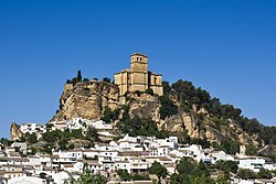
Montefrio is a municipality in the province of Granada. The ruins of a Moorish castle sit near the highest point. Being built midway between the Sierra de Priego and Sierra Parapanda, and commanding the open valley between these ranges, it became one of the chief frontier fortresses of the Moors in the 15th century.

Contents

The climate of Montefrío is a continental Mediterranean type. The economy is typically agrarian, with olives as the main crop. The relatively limited industry revolves around agricultural processing such as oil and dairy products. The population is reported as 6,688, with 3,337 men and 3,351 women. Near the town is a vast archaeological site known as Las Peñas de los Gitanos, famous for its prehistoric tombs and remains of Roman and Visigothic settlements.

Montefrío's main road has many shops, cafes, bars and restaurants which are independently run. It leads on to Plaza Virgen de Los Remedios which then leads on to Plaza de España.

Montefrio's primary church is the only round church in the whole of Spain since its recapture from Muslim control. The church is said to have been converted from an old mosque.

Etymology

The town's name means "cold mountain", from Spanish monte frio.

Geography

Montefrío is in the northwest of the province of Granada, situated in the region of Loja. The township occupies about 254 km2 and has a density of 25.37 inhabitants / km ². Its geographical coordinates are 37 ° 19 'N, 04 ° 01' W. It is situated at an altitude of 834 m and 57 km from the capital of Granada. Montefrio is limited on the north with the municipalities of Priego de Córdoba and Almedinilla (Córdoba) and Alcalá la Real (Jaén); the southeast with íllora, on the south by Villanueva Mesia and Stump; and on the southwest by Loja and Algarinejo, the latter belonging to the province of Granada.

Districts

The municipality counts with the annexed of Lojilla. This small village is located about 7 km from the village. The only access is to Lojilla is by the road between Montefrío and Alcalá la Real, from the junction at “La venta del conejo”. Its altitude is 994.3 meters and the terrain has a slope of 20.89%. Its population is 79 inhabitants. They celebrate a feast on 20 January in honor of its patron saint San Sebastian, and on July 25, the feast of Santiago. They highlight the festival of San Sebastián. The amazing thing about this festival is that locals walk through the streets of the village dressed in colorful costumes, hats with bells and ribbons which are also colored. Jumping, dancing and begging passers towards the cost of the party. It was ancient custom that were getting farmhouse cottage in cakes, oil and melons.[ clarification needed ] The beginning is in the late afternoon and after a day of olive picking and last until the early hours of the night. Flush (coffee with anise) and typical local products such as chorizo and morcilla grilled are taken.

The origin of the festival is unknown, but is believed that the party is related with the one celebrated in Los Verdiales (Málaga) because of the similarity of its outfit. After 15 years without taking place, it was celebrated again in 2010. The party seeks to be declared by their ancestral origin and singularity of interest by the Junta de Andalucía.

Hydrography

The township has four main streams:

Climate

Montefrío climate is Mediterranean with continental features. It is not particularly cold, with rainy winters and hot, dry summers. Autumns and Springs are mild and slightly rainy. According to a study by the Council of Granada, made in the early 1990s, between three distinct locations (Cortijo de Tara, Lojilla and Montefrío), the following data are derived:

Data should not be taken too seriously, because within the same municipality, there are areas with higher rainfall than others. In some areas if this average is reached, other do not get to 500 mm per year.

Communications

The A-335 crosses through the town from north to south. To the east is the NO-26 which also binds to the N-432 as it passes through Puerto Lope and is the shortest way to get to Granada.

From the A92, exit Huétor-Tájar, then up the road connecting the two towns, bordering the creek Milanos, which is the best option. One can also reach Montefrío from neighboring villages and Algarinejo íllora through local roads. The major elevations are the Sierra de Parapanda with 1,604 m at the boundary between Montefrío and íllora, and saw the peak Chanzas Pepper of 1,213 m between Montefrío and Algarinejo.

Economy

Montefrio Montefrio - DSC 2833.JPG
Montefrío

Montefrio's economy is based on agriculture and animal husbandry. Must emphasize the 16,221 olives of which 15204 belong to dry farming and irrigated rest. Within arable crops we highlight the 471 ha of barley and 12 ha of potato (SIMA 2007).

As for livestock, Montefrío in the eighteenth century became one of the most important pastoral areas of eastern Andalusia (about 50,000 head of cattle). Currently these figures are substantially lower, highlighting the pigs won, goat and sheep. It is this primary sector that derives little existing industry. A cooperative dairy related products, the cheese is famous throughout Spain; several mills, two of which incorporated cooperatives; companies engaged in the development of products derived from the olive; and a high-quality meat products.

Montefrío has one of the richest historical and cultural heritages in the province of Granada and is one of Andalucia’s famous “Pueblos Blancos” (white towns of Andalucia). Tourism in Montefrío has escalated in recent years having been named a top 10 National Geographic [2] views of a pueblo (town) in 2017. There are several fiestas (festivals) throughout the year, notably the month long “Fiesta de Agosto” (August Festival). With so much to see and do in Montefrío its culture, fiestas, famous heritage sites and award winning produce attracts tourists throughout the year.

Related Research Articles

Jaén, Spain Municipality in Andalusia, Spain

Jaén, is the urban capital city of the province of Jaén, in the autonomous community of Andalusia, Spain.

Province of Granada Province of Spain

Granada is a province of southern Spain, in the eastern part of the autonomous community of Andalusia. It is bordered by the provinces of Albacete, Murcia, Almería, Jaén, Córdoba, Málaga, and the Mediterranean Sea. Its capital city is also called Granada.

Priego de Córdoba Municipality in Andalusia, Spain

Priego de Córdoba is a town and municipality of Spain located in the autonomous community of Andalusia. It lies on the southeasternmost end of the province of Córdoba, near the headwater of the Guadajoz, and on the northern slope of the Sierra de Priego. The population in 2015 was 22,936.

Ubrique Municipality in Spain

Ubrique is a municipality of Spain located in the province of Cádiz, in the autonomous community of Andalusia. According to the 2005 census, it has a population of 17,362 inhabitants. It is the most important municipality in the Sierra de Cádiz.

Alcalá del Valle Municipality in Andalusia, Spain

Alcalá del Valle is a city located in the province of Cádiz, Spain. According to the 2006 census, the city has a population of 5,355.

Alcalá de los Gazules Municipality in Andalusia, Spain

Alcalá de los Gazules is a city and municipality located in the province of Cádiz, Spain. According to the 2006 census, the town has a population of 5,633 inhabitants. Alcalá de los Gazules is situated in the Sierra de Cádiz.

Iznájar

Iznájar is a town and municipal area in the province of Córdoba in Andalucia, southern Spain.

Autovía A-92 Road in Spain

The Autovía A-92 is a highway in Andalusia, Spain. It is a major east–west route running south of the Sierra Nevada and is known as the Carretera Sevilla a Granada and Autovía de Andalucía.

Genil

The Genil River is the main (left) tributary of the river Guadalquivir in Andalusia, Spain. The Roman Singilis, its modern name derives from the Moorish rendering of the Roman name: Sinyil, Sannil, and Sinnil.

Villanueva del Rosario, Andalusia Place in Andalusia, Spain

Villanueva del Rosario is a town and municipality in the province of Málaga in the autonomous community of Andalusia in southern Spain. It is located off the motorway from Málaga to Granada and Seville. It is situated in the northeast of the province. It belongs to the comarca of Nororma.

Alfacar Place in Spain

Alfacar is a historic town approximately 8 kilometres (5.0 mi) from the city of Granada, in the autonomous Spanish region of Andalucia. In the 2005 census, INE reported its population as 5107 inhabitants. The town is on the edge of the Sierra de Huétor Natural Park and is in a region of intensive olive production. The town is 920 metres (3,020 ft) above sea level, but the local fossil record contains marine molluscs that show the profound geological forces that have shaped the region.

Las Gabias is a Spanish city and municipality located in the central southern part of the Vega of Granada, in the province of Granada, in the autonomous community of Andalusia, approximately 8 km from the provincial capital of Granada. It borders the municipalities of Vegas del Genil, Cúllar Vega, Churriana de la Vega, Alhendín, La Malahá, Chimeneas and Santa Fe. Las Gabias includes the localities of “Gabia Grande”, the municipal capital, and “Gabia Chica” that were a unified with the region in 1973, in addition to the annexation of Híjar, Los Llanos, Pedro Verde and San Javier. The name may have originated from Hisn Caviar, which means “military tower”, in allusion to the one that still exists in Gabia Grande. It is one of the most populous municipalities in Spain as well as one of the youngest, with the median age of inhabitants being only 34.3 years of age. In 2016, the population of Las Gabias surpassed 20,000, making it the fourth most populous municipality in the Granada Metropolitan Area, surpassed only by Granada, Armilla and Maracena.

Huétor-Tájar Place in Granada, Spain

Huétor-Tájar is a municipality and town located in the province of Granada (Andalusia), in the southern Spain. It is situated 43 km west of the city of Granada, and its population in 2007 was 9,467. The municipality's extension is close to 40 km². Huétor-Tájar lies within the fertile Genil river valley, a part of the Granada depression.

Subbaetic System

The Subbaetic or Sub-Baetic System is one of the three systems of mountain ranges of the Baetic System in the southern Iberian Peninsula. Highest point 2,027 m (6,650 ft) high Peña de la Cruz in Sierra Arana. Its northern limit includes the valley of the Guadalquivir in its western part.

Granada Basin

The Granada Basin, Depression of Granada or Granada Depression is a totally enclosed valley in Andalusia, Spain. The river Genil runs through the valley upon exiting from the Sierra Nevada until it passes through the Infiernos de Loja. On the north it borders the comarca of Los Montes on the southern border of the Cordillera Subbética; on the north west are the Sierra de Loja and El Hacho; on the southwest the Sierra Gorda; in the south the Sierra de la Almijara; and in the east the aforementioned Sierra Nevada. It is one of the series of valleys forming the Surco Intrabético.

Frailes, Spain Municipality in Andalucía, Spain

Frailes is a municipality in the Spanish province of Jaén, autonomous community of Andalucia, with a total area of 41,37 km2, a population of 1775 inhabitants and a population density of 43,41 inhab/ km2. It has been immortalised by the British writer, Michael Jacobs, in his 2003 book, The Factory of Light.

Íllora Municipality in Andalusia, Spain

Íllora is a municipality in the province of Granada, located in Andalucia. Spain. It is surrounded by the following villages: Moclín, Pinos Puente, Valderrubio, Moraleda de Zafayona, Villanueva Mesía, Montefrío, and with the municipality of Alcalá la Real. The municipality consists of Íllora, Alomartes, Tocón, Escóznar, Obéilar- also known as La Estación de Íllora–, Brácana, Ventas de Algarra, Vallequemado and La Alhondiguilla.

Monachil Municipality in Granada, Spain

Monachil is a municipality in the province of Granada, Spain. As of 2018, it has a population of 7,826 inhabitants. It lies around 8 km from the city of Granada. It borders the municipalities of Huétor Vega, Cenes de la Vega, Pinos Genil, Güéjar Sierra, Dílar, La Zubia and Cájar.

Comarca de Loja Comarca in Andalusia, Spain

Comarca de Loja is a comarca in the province of Granada, Spain. It contains the following municipalities:

References

  1. Municipal Register of Spain 2018. National Statistics Institute.
  2. "10 pueblos con las mejores vistas del mundo". viajes.nationalgeographic.com.es (in Spanish). 2015-03-20. Retrieved 2020-09-02.

Wikisource-logo.svg This article incorporates text from a publication now in the public domain : Chisholm, Hugh, ed. (1911). "Montefrio". Encyclopædia Britannica . Vol. 18 (11th ed.). Cambridge University Press. p. 765.