
Leverett is a town in Franklin County, Massachusetts, United States. The population was 1,865 as of the 2020 census. It is part of the Springfield, Massachusetts Metropolitan Statistical Area.

The Gurleyville Historic District encompasses a formerly industrial rural crossroads village in Mansfield, Connecticut. Centered on Gurleyville and Chaffeeville Roads, it includes a collection of mainly vernacular 19th-century residences, a stone gristmill dating to about 1749, and the archaeological remains of later industrial endeavours. The district was listed on the National Register of Historic Places in 1975.

The South Lee Historic District encompasses the historic portion of the village of South Lee in Lee, Massachusetts. Extending mainly along Massachusetts Route 102 between Fairview Street and the Stockbridge town line, the village is a well-preserved 19th-century mill village, with fine Federal and Greek Revival buildings and a later 19th-century paper mill. It was listed on the National Register of Historic Places in 1999.
The Colrain Center Historic District encompasses the historic center of Colrain, Massachusetts, a rural hill town in north-western Franklin County. The 30-acre (12 ha) district was listed on the National Register of Historic Places in 2006.

The Montague Center Historic District encompasses the well-preserved 19th century village center of Montague, Massachusetts. Montague Center, one of the town's five villages, is the civic heart of the town, and was also an active industrial area in the 19th century. The district was listed on the National Register of Historic Places in 2001.

The Wendell Town Common Historic District encompasses the historic heart of the small town of Wendell, Massachusetts. Centered on a town common established in 1782, it includes a significant number of well preserved Greek Revival buildings. The district was listed on the National Register of Historic Places in 1992.

The South Worthington Historic District is a historic district encompassing the formerly industrial, but now rural, village of South Worthington, Massachusetts. The village is centered on the junction of Huntington Road, Ireland Street, and Thrasher Hill Road. The district extends along Ireland Road as far as Conwell Road, and one contributing element, the dam which impounds Little Galilee Pond, extends into neighboring Chesterfield. The area had a number of small mills along the banks of the Little River, a tributary of the Westfield River, but only one complex, the Theron Higgins Mill on South Worthington Road, has survived from the 19th century. Most of the buildings in the district are residences dating to the 19th century; also included are three churches, including the particularly elegant Greek Revival South Worthington Methodist Church (1848). The district was added to the National Register of Historic Places in 2005.
The North Chester Historic District is a historic district encompassing the rural village center of North Chester in the town of Chester, Massachusetts. One of the rural community's early settlement nodes, it thrived into the early 19th century around a stagecoach tavern, a few small mills, and farming, and retains buildings and archaeological remains representative of this history. The district was listed on the National Register of Historic Places in 1998.
The Brookside Historic District of Westford, Massachusetts encompasses surviving elements of the 19th century Brookside mill village, the smallest of the town's three 19th-century industrial villages. Developed between about 1860 and 1904, it includes surviving mill buildings and a variety of mill-related worker housing. The district was listed on the National Register of Historic Places in 2003.
The Arlington Center Historic District includes the civic and commercial heart of Arlington, Massachusetts. It runs along the town's main commercial district, Massachusetts Avenue, from Jason Street to Franklin Street, and includes adjacent 19th- and early 20th-century residential areas roughly bounded by Jason Street, Pleasant Street, and Gray Street. The district was listed on the National Register of Historic Places in 1974.

The Waterville Village Historic District encompasses most of the history 19th and early 20th-century village center of Waterville, Vermont. The village grew from beginnings late in the 18th century to serve as a modest civic, commercial, and residential hub for the rural community. It was added to the National Register of Historic Places in 2007.

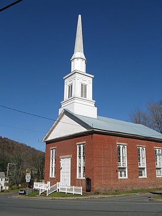
North Leverett is a historic mill village of Leverett, Massachusetts. Centered on the intersection of North Leverett Road with Chestnut Hill Road and Cave Hill Road it includes predominantly residential buildings that were built during the height of the area's industrial activity between the 1770s and mid-19th century. The architecture is mainly Federal and Greek Revival in style, including the 1832 North Leverett Baptist Church. The Slarrow Mill is the only remaining component of the village's industrial past. The village was listed as a historic district on the National Register of Historic Places in 2014.

The Leverett Center Historic District is an expansive 467-acre (189 ha) historic district encompassing the historic heart of the rural community of Leverett in eastern Franklin County, Massachusetts. The district is focused on a two-mile stretch of Depot and Montague Roads, at whose center is the civic heart of the town. It includes the 1838 Greek Revival First Congregational Church, the town hall, whose present form was achieved in 1895 by raising the 1845 construction and building a first floor underneath it, and the Colonial Revival Field Memorial Library (1916). It also includes a town pound built c. 1822, and a number of 18th century residences. The district was listed on the National Register of Historic Places in 2008.

The East Leverett Historic District of Leverett, Massachusetts, encompasses the historic mill village of East Leverett. Centered on the intersection of Cushman Road and Shutesbury Road in the southeastern portion of the rural town, it includes predominantly residential buildings that were built during the height of the area's industrial activity in the first four decades of the 19th century. The architecture is mainly Federal and Greek Revival in style. The district was listed on the National Register of Historic Places in 2014.

The Lyme Center Historic District encompasses a modest crossroads and industrial village in rural Lyme, New Hampshire. The predominantly residential district stretches along Dorchester Road, on either side of its junction with Baker Hill Road. The village's rise in development started in the early 19th century as it was at a crossroads of the east-west Dorchester Road, and the north-south Baker Hill Road and Acorn Hill Road. The village grew rapidly in the 1820s, with a number of simple Greek Revival houses, and in 1830 the Baptist Church was built. The other major civic building in the village is the Lyme Academy, built in 1839, albeit with more Federal than Greek Revival styling. Grant Brook, which runs parallel to Dorchester Road, provided a source of power for the growth of small industrial efforts, including a sawmill at the corner of Dorchester and Baker Hill Roads. This industry provided a second minor building boom in the late 19th to early 20th century. Most of the houses in the district are vernacular Greek Revival or Cape in their styling; probably the most elaborate Greek Revival house is the 1857 Beal-Pike House at 41 Dorchester Road.

The Danby Village Historic District encompasses much of the town center of Danby, Vermont. It is centered on a stretch of Main Street, roughly between Depot Street and Brook Road. The village has a cohesive collection of mid-19th century architecture, mostly residential, with a modest number of later additions. The district was listed on the National Register of Historic Places in 1983.

The Thetford Center Historic District encompasses the village of Thetford Center in Thetford, Vermont. The village contains a well-preserved collection of early to mid-19th century architecture, a legacy of its period of greatest prosperity as an agricultural and industrial center. It was listed on the National Register of Historic Places in 1998.

The Kents Corner Historic District encompasses a well-preserved 19th-century crossroads hamlet in Calais, Vermont. Centered on the junction of Kent Hill Road, Old West Church Road, and Robinson Cemetery Road, it developed as a stagecoach stop with a small industrial presence. It was listed on the National Register of Historic Places in 1973, and substantially enlarged in 2006.

The Manchaug Village Historic District is a historic district encompassing the 19th century industrial village center of Manchaug in Sutton, Massachusetts. Developed in the 1820s around textile mills on the Mumford River, it was the largest industrial area in Sutton, with at least three mill complexes in operation. The district is centered on the junction of Main Street with Manchaug, Putnam Hill, and Whitins Roads.

Franklin Corners is an unincorporated community located along the Passaic River at the intersection of County Route 613 and U.S. Route 202 in Bernards Township of Somerset County, New Jersey. In the 19th century, it had a grist mill, saw mill, general store, school, and several houses. The Franklin Corners Historic District, featuring Van Dorn's Mill, was listed on the National Register of Historic Places in 1975.


