
Lake Gairdner National Park is a protected area associated with Lake Gairdner in South Australia (Australia), 436 km northwest of Adelaide. It is located just south of the Trans-Australian Railway, Stuart Highway, and the Woomera Prohibited area.

Grafton is a city in the Northern Rivers region of the Australian state of New South Wales. It is located on the Clarence River, on a floodplain, approximately 620 kilometres (385 mi) by road north-northeast of the state capital Sydney.

Burwood is an inner eastern suburb of Melbourne, Victoria, Australia, 14 kilometres east of Melbourne's Central Business District, located within the Cities of Monash and Whitehorse local government areas. Burwood recorded a population of 15,147 at the 2021 census.

Ryde is a suburb of Sydney, New South Wales, Australia. Ryde is located 13 km north-west of the Sydney central business district and 8 km east of Parramatta. Ryde is the administrative centre of the local government area of the City of Ryde and part of the Northern Sydney region. It lies on the north bank of the Parramatta River. People from Ryde are colloquially known as Ryders, Rydiens or Rydemen.

Richmond is an inner-city suburb in Melbourne, Victoria, Australia, 3 km (1.9 mi) east of the Melbourne central business district, located within the City of Yarra local government area. Richmond recorded a population of 28,587 at the 2021 census, with a median age of 34.

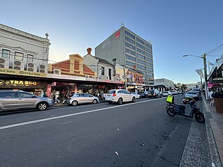
Malvern ( ) is a suburb of Melbourne, Victoria, Australia, 8 km south-east of Melbourne's Central Business District, located within the City of Stonnington local government area. Malvern recorded a population of 9,929 at the 2021 census.

South Yarra is an inner-city suburb in Melbourne, Victoria, Australia, 4 km south-east of Melbourne's Central Business District, located within the Cities of Melbourne and Stonnington local government areas. South Yarra recorded a population of 25,028 at the 2021 census.

Toorak is a suburb of Melbourne, Victoria, Australia, 5 km (3.1 mi) south-east of Melbourne's Central Business District, located within the City of Stonnington local government area. Toorak recorded a population of 12,817 at the 2021 census.
Dianella is a suburb of Perth, Western Australia. It is within the local government area of the City of Stirling.

Clarence Valley Council is a local government area in the Northern Rivers region of New South Wales, Australia.
Strathfield is a suburb in the Inner West of Sydney, in the state of New South Wales, Australia. It is located 12 kilometres west of the Sydney central business district and is the administrative centre of the Municipality of Strathfield. A small section of the suburb north of the railway line lies within the City of Canada Bay, while the area east of The Boulevard lies within the Municipality of Burwood. North Strathfield and Strathfield South are separate suburbs to the north and south, respectively.

Broadway is a 700-metre (2,300 ft) road in inner city Sydney, New South Wales, Australia. The road constitutes the border between the suburbs of Ultimo and Chippendale. Broadway is also an urban locality.

Mount Hotham is a mountain located in the Victorian Alps of the Great Dividing Range, in the Australian state of Victoria. The mountain is located approximately 357 kilometres (222 mi) north east of Melbourne, 746 kilometres (464 mi) from Sydney, and 997 kilometres (620 mi) from Adelaide by road. The nearest major road to the mountain is the Great Alpine Road. The mountain is named after Charles Hotham, Governor of Victoria from 1854 to 1855.

Erina is a suburb located in the Central Coast region of New South Wales, Australia. Erina is the largest commercial hub of the Central Coast and is home to the largest single level shopping centre in the Southern Hemisphere that is called Erina Fair. It is part of the Central Coast Council local government area.

Mount Magnificent Conservation Park is a protected area in the Australian state of South Australia located in the Mount Lofty Ranges about 58 kilometres south of the state capital of Adelaide. It is located within the gazetted locality of Mount Magnificent.

Melbourne is the capital and most populous city of the Australian state of Victoria, and the second-most populous city in Australia, after Sydney. The city's name generally refers to a 9,993 km2 (3,858 sq mi) metropolitan area also known as Greater Melbourne, comprising an urban agglomeration of 31 local government areas. The name is also used to specifically refer to the local government area named City of Melbourne, whose area is centred on the Melbourne central business district and some immediate surrounds.

The Harwood Bridge is a two-lane steel truss bridge which carried the Pacific Highway over the Clarence River in the Northern Rivers region of New South Wales, Australia from 1966 until 2019, when it was replaced by a four-lane 1.5-kilometre-long (4,921 ft) concrete bridge, located 20 metres (66 ft) to its east. The Harwood Bridge has been retained to provide access to Harwood Island.
Moody Tank Conservation Park is a protected area located in the Australian state of South Australia on the Eyre Peninsula about 26 kilometres north-east of Cummins.
Penambol Conservation Park is a protected area in the Australian state of South Australia located in the state's south-east in the gazetted locality of Caroline about 22 kilometres (14 mi) south-east of the city centre in Mount Gambier.
Aberdour Conservation Park is a protected area in the Australian state of South Australia located in the state's south-east in the locality of Willalooka about 226 kilometres (140 mi) south-east of the state capital of Adelaide and about 35 kilometres (22 mi) south of the town of Keith.

