
Western Sydney University, formerly the University of Western Sydney, is an Australian multi-campus university in the Greater Western region of Sydney, Australia. The university in its current form was founded in 1989 as a federated network university with an amalgamation between the Nepean College of Advanced Education and the Hawkesbury Agricultural College. The Macarthur Institute of Higher Education was incorporated in the university in 1989. In 2001, the University of Western Sydney was restructured as a single multi-campus university rather than as a federation. In 2015, the university underwent a rebranding which resulted in a change in name from the University of Western Sydney to Western Sydney University. It is a provider of undergraduate, postgraduate, and higher research degrees with campuses in Bankstown, Blacktown, Campbelltown, Hawkesbury, Liverpool, Parramatta, and Penrith.
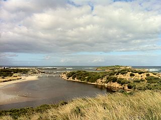
Warrnambool is a city on the south-western coast of Victoria, Australia. At June 2016, Warrnambool had an estimated urban population of 35,214. Situated on the Princes Highway, Warrnambool (Allansford) marks the western end of the Great Ocean Road and the southern end of the Hopkins Highway.

Orange is a city in the Central Tablelands region of New South Wales, Australia. It is 254 km (158 mi) west of the state capital, Sydney [206 km (128 mi) on a great circle], at an altitude of 862 metres (2,828 ft). Orange had an estimated urban population of 40,493 as of June 2018 making the city a significant regional centre. A significant nearby landmark is Mount Canobolas with a peak elevation of 1,395 m (4,577 ft) AHD and commanding views of the district.

St Ives is a suburb on the Upper North Shore of Sydney in the state of New South Wales, Australia 18 kilometres north of the Sydney Central Business District in the local government area of Ku-ring-gai Council. St Ives Chase is a separate suburb, to the north.
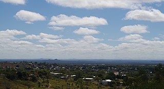
Charters Towers is a town within the Charters Towers Region in northern Queensland, Australia. It is 134 kilometres (83 mi) inland (south-west) from Townsville on the Flinders Highway. At the 2016 census the population was 8,120 people. During the last quarter of the 19th century the town boomed as the rich gold deposits under the city were developed. After becoming uneconomic in the 20th century, profitable mining operations have commenced once again.
Herberton is a rural town and locality in the Tablelands Region, Queensland, Australia. In the 2016 census, Herberton had a population of 855 people.

Villers-Bretonneux is a commune in the Somme department in Hauts-de-France in northern France.

Sutton, meaning 'South Settlement' in Saxon, is a small village in the Southern Tablelands of New South Wales, Australia in Yass Valley Shire. It is situated on the west bank of the Yass River, about 17 kilometres south of Gundaroo, near the Federal Highway, not far from Canberra. It has a primary school, an Anglican church, a general store, an estate agent, a rural supply store and a baker. Sutton has its own volunteer Bush Fire Brigade located in the village.

Forest Lake is an outer south-western suburb of the City of Brisbane, Queensland, Australia. In the 2016 census, Forest Lake had a population of 22,904 people.

Seaham is a suburb of the Port Stephens local government area in the Hunter Region of New South Wales, Australia. It is located on the Williams River which flows into the Hunter River 14.6 km (9.1 mi) downstream from Seaham village at Raymond Terrace.

Miles is a town and a locality in the Western Downs Region, Queensland, Australia. In the 2016 census, Miles had a population of 1,746 people.

Highfields is both a town and a locality in the Toowoomba Region, Queensland, Australia. At the 2016 census, Highfields had a population of 8,131. At June 2015, the estimated urban population for the Highfields urban area was 18,771. In 2017, it was the fastest growing area in Toowoomba.

Collingullie is a village 26 kilometres (16 mi) north-west of Wagga Wagga in the Riverina region of New South Wales, Australia. The village is located on the Sturt Highway, between Wagga Wagga and Narrandera, at the crossroads with the road to Lockhart.

Sougb, or Sogh, is a Papuan language of the East Bird's Head language family spoken in the east of the Bird's Head Peninsula to the east of Meyah and to the south of Manokwari, including the area of Soug Jaya District, Teluk Wondama Regency. It consists of four dialects and is spoken by around 12,000 people in all. The language is alternatively known as Mantion, or Manikion, an originally derogatory term used by the Biak people.

Bendemeer is a village of 485 people on the Macdonald River in the New England region of New South Wales, Australia. It is situated at the junction of the New England and Oxley Highways.

Kingsthorpe is a rural town and locality in the Toowoomba Region, Queensland, Australia. In the 2016 census, Kingsthorpe had a population of 1,867 people.

Wollombi is a small village in the Hunter Region of New South Wales, Australia. It is within the Cessnock City Council LGA, situated 29 kilometres (18 mi) southwest of Cessnock and 128 km (80 mi) north of Sydney. To the south is the village of Laguna, to the east, the village of Millfield and to the north, the village of Broke.

Preston is a rural locality split between the Toowoomba Region and the Lockyer Valley Region in Queensland, Australia. In the 2016 census Preston had a population of 614 people.
Cardstone is a rural locality in the Cassowary Coast Region, Queensland, Australia. In the 2016 census Cardstone had a population of 17 people.

Tamborine is a town in the Scenic Rim Region and a locality split between the Scenic Rim Region and the City of Logan in Queensland, Australia. In the 2016 census the locality of Tamborine had a population of 3,950 people.
