
Tamworth is a city and administrative centre of the north-eastern region of New South Wales, Australia. Situated on the Peel River within the local government area of the Tamworth Regional Council, it is the largest and most populated city in the region, with a population of 43,874 in 2021, making it the second largest inland city in New South Wales. Tamworth is 318 km (198 mi) from the Queensland border and is located almost midway between Brisbane and Sydney.

Liverpool is a suburb of South Western Sydney, in the state of New South Wales, Australia. It is located approximately 31 kilometres (19 mi) south-west of the Sydney CBD. Liverpool is the administrative seat of the local government area of the City of Liverpool and is situated in the Cumberland Plain.
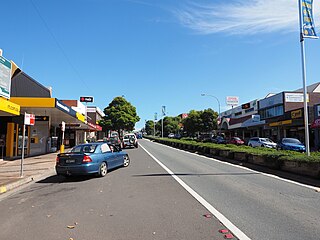
Ulladulla is a coastal town in New South Wales, Australia in the City of Shoalhaven local government area. It is on the Princes Highway about 230 kilometres (140 mi) south of Sydney, halfway between Batemans Bay to the south and Nowra to the north. Ulladulla has close links with the nearby historic settlement of Milton and many services are shared between these towns.

Coonabarabran is a town in Warrumbungle Shire that sits on the divide between the Central West and North West Slopes regions of New South Wales, Australia. At the 2021 census, the town had a population of 2,387, and as of 2021, the population of Coonabarabran and its surrounding area is 3,477. Local and district residents refer to the town as 'Coona'. Coonabarabran is the gateway to the Warrumbungle National Park, Siding Spring Observatory and the Pilliga Forest.
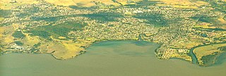
Dapto is a suburb of Wollongong in the Illawarra region of New South Wales, Australia, located on the western side of Lake Illawarra and covering 7.15 square kilometres (2.76 sq mi). As at the 2021 census, the suburb had a population of 10,954.

Scone is a town in the Upper Hunter Shire in the Hunter Region of New South Wales, Australia. At the 2021 census, Scone had a population of 5,013 people. It is on the New England Highway north of Muswellbrook about 270 kilometres(167.77 miles) north of Sydney, and is part of the New England (federal) and Upper Hunter (state) electorates. Scone is in a farming area and is also noted for breeding Thoroughbred racehorses. It is known as the 'Horse capital of Australia'.

Molong is a small town in the Central West region of New South Wales, Australia, in Cabonne Shire.

Clarence Valley Council is a local government area in the Northern Rivers region of New South Wales, Australia.

Aberdeen is a small town in the upper Hunter Region of New South Wales, Australia, in Upper Hunter Shire. It is 12 kilometres north of Muswellbrook on the New England Highway.

Macksville is a small town on the Nambucca River in the Nambucca Valley, New South Wales, Australia. It is halfway between Sydney and Brisbane, along the Pacific Highway, approximately 40 minutes north of Kempsey, 40 minutes south of Coffs Harbour, 70 minutes north of Port Macquarie, five hours south of Brisbane and five hours north of Sydney.

Casino is a town in the Northern Rivers area of New South Wales, Australia, with a population of 9,968 people at the 2021 census. It lies on the banks of the Richmond River and is situated at the junction of the Bruxner Highway and the Summerland Way.

Muswellbrook is a town in the Upper Hunter Region of New South Wales, Australia, about 243 km (151 mi) north of Sydney and 127 km (79 mi) north-west of Newcastle.

Murrurundi( MURR-oo-RUN-dye), is a rural town located in the Upper Hunter Shire, in the Upper Hunter region of New South Wales, Australia.

Nambucca Heads is a town on the Mid North Coast of New South Wales, Australia in the Nambucca Valley. It is located on a ridge, north of the estuary of the Nambucca River near the Pacific Highway. Its 2021 population was 6,675, including 5,226 (78.3%) Australian-born persons and 672 indigenous persons.

Greta is a small town in the Hunter Region of New South Wales, Australia.
Nana Glen is a small village in New South Wales, Australia, located 25 km inland north-west of Coffs Harbour in the City of Coffs Harbour. It is located on the Orara Way and at the juncture of two main roads, one leading to Lower Bucca. The Orara Way is the main thoroughfare through the township and is an alternative route between Grafton and Coffs Harbour. Nana Glen is situated between the township of Coramba and Glenreagh.The local Mayor is Alison Johnson MD.

The City of Newcastle is a local government area in the Hunter region of New South Wales, Australia. The City of Newcastle incorporates much of the area of the Newcastle metropolitan area.

Murrumburrah is a township in New South Wales, Australia, part of a twin town with Harden. The town is in Hilltops Council local government area in the South West Slopes area of NSW. It is on the Burley Griffin Way, the major link from the Riverina to the Hume Highway near Yass, and ultimately Sydney, Canberra and the coast.

Dorrigo, a small town on the Waterfall Way, is located on the Northern Tablelands, in northern New South Wales, Australia. The town is part of Bellingen local government area.

Massie is a rural locality in the Southern Downs Region, Queensland, Australia. In the 2021 census, Massie had a population of 113 people.
