
The Second Church in Newton, United Church of Christ, is located at 60 Highland Street in West Newton, a village of Newton, Massachusetts. This church is rooted in the Congregational denomination, welcomes all visitors, and does not require uniformity of belief. Its present church building, a Gothic Victorian structure designed by architects Allen & Collens and completed in 1916, was listed in the National Register of Historic Places in 1990.

The Kensington Park Historic District of Arlington, Massachusetts encompasses a turn of the 20th century planned residential subdivision in the hills above the town center, representing an early phase in the town's transition from a rural to suburban setting. The district consists of most of the houses on Brantwood and Kensington Roads, which wind around a rocky hillside overlooking Pleasant Street and Spy Pond, just west of the center. A number of the houses are the work of architect C. Herbert McClare, who also lived in the area, and was one of the development's proponents. The district was listed on the National Register of Historic Places in 1985.

The Everett Avenue–Sheffield Road Historic District is a historic district encompassing one of the finest residential districts from the turn of the 20th century in Winchester, Massachusetts. The district is roughly triangular in shape, bounded in the north by Bacon Street, on the west by Church Street, Sheffield West, and Sheffield Road, and on the south and heast by the Upper Mystic Lake and Mystic Valley Parkway. It is characterized by winding roads, with relatively large houses on well-proportioned lots. Most of the houses were built between 1890 and 1916, and all exhibit some architectural sophistication. A significant number of properties were designed by either F. Patterson Smith or Dexter Blaikie, two local architects. The district was listed on the National Register of Historic Places in 1989.

The Wedgemere Historic District encompasses the largest single 19th-century residential development of Winchester, Massachusetts. It is one of the town's largest surviving 19th-century residential subdivisions, with a concentration of high-quality residences built between about 1890 and 1920. The district was listed on the National Register of Historic Places in 1989.
The Washington Square Historic District of Lowell, Massachusetts encompasses a historic subdivision laid out in 1832. The focal point of the subdivision is Kittridge Park, which lies on the eastern side of the district and was an original part of the subdivision plan developed by the Nesmith Brothers. It was the first significant residential subdivision in the city aimed at a wealthier clientele, and was designed by landscape architect Alexander Wadsworth. The district was added to the National Register of Historic Places in 1982, and expanded slightly in 1999.

Hammond Heights is an historic neighborhood subdivision on the west side of Worcester, Massachusetts. It includes properties along Germain, Haviland, Highland, and Westland Streets and Institute Road, most of which were built between 1890 and 1918, and is a good example of a turn-of-the-century residential subdivision, with a diversity of period architectural styles. The district was listed on the National Register of Historic Places in 1980.

The Brae Burn Road Historic District is a residential historic district on Brae Burn and Windermere Roads in Newton, Massachusetts. It encompasses as modest residential subdivision that was laid out in the then-rural area of Auburndale in 1911. Many of its houses were designed by the regionally notable firm of Gay & Proctor, and represent a well-preserved collection of modestly scaled Craftsman and Colonial Revival style houses. The district includes 26 houses. The district was listed on the National Register of Historic Places in 1990.

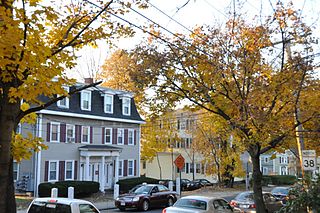
The Commonwealth Avenue Historic District of Newton, Massachusetts, encompasses roughly the eastern half of Commonwealth Avenue, extending from Waban Hill Road, near the city line with Boston, westward to Walnut Street. The roadway was laid out in 1894 and completed in 1895. Its design was influenced in part by the local residents, who were willing to give land for some of the route, and the design of Boston portions of the road, in which Frederick Law Olmsted was involved. Construction of the roadway was followed by the construction of fashionably large residences along its route, which took place mostly between the road's construction and about 1920. The district includes 188 residential properties, which are mainly built in the revival styles popular in the early 20th century. The district was added to the National Register of Historic Places in 1990.
The Farlow Hill Historic District is a residential historic district in the Newton Corner area of Newton, Massachusetts, United States. It includes houses on Shornecliffe Road, Beechcroft Road, Farlow Road, Huntington Road, and a few properties on immediately adjacent streets. Most of the houses in the district were built between 1899 and the late 1920s and are either Craftsman or Colonial Revival in their style. The area was created by the subdivision of the estate of John Farlow, and includes 37 large and well-appointed houses, generally architect-designed, on ample lots. The district was listed on the National Register of Historic Places in 1990.

The Gray Cliff Historic District is a residential historic district encompassing a cluster of exceptionally high quality houses built in Newton, Massachusetts, between about 1890 and 1940. When first listed on the National Register of Historic Places in 1986, it included only the eight houses at 35, 39, 43, 53, 54 ,, 64, 65, and 70 Gray Cliff Road, which were predominantly Shingle style house built before the turn of the 20th century. The district was expanded in 1990 to include an adjacent area known as The Ledges, where the houses were built between 1900 and 1940, and are mainly Colonial Revival and Tudor Revival in their styling.

The Monadnock Road Historic District is a residential historic district encompassing a cohesive subdivision of a former estate in the 1920s in the Chestnut Hill section of Newton, Massachusetts. The development was typical of Newton's explosive residential growth at that time, and includes primarily Tudor Revival houses. The district was listed on the National Register of Historic Places in 1990.

The Old Chestnut Hill Historic District encompasses the historic residential heart of the Newton portion of Chestnut Hill, Massachusetts. When first listed on the National Register of Historic Places in 1986, the district extended along Hammond Street, between Beacon Street and the MBTA Green Line right-of-way, and along Chestnut Hill Road between Hammond and Essex, including properties along a few adjacent streets. The district was expanded in 1990 to include more of Chestnut Hill Road and Essex Road, Suffolk Road and the roads between it and Hammond, and a small section south of the Green Line including properties on Hammond Street, Longwood Road, and Middlesex Road. A further expansion in 1999 added a single property on Suffolk Road.

The Pine Ridge Road–Plainfield Street Historic District encompasses a residential subdivision in the Waban section of Newton, Massachusetts. It includes 44 properties on Pine Ridge Road and Plainfield Street between Chestnut Street and Upland Road, and includes a few properties on the latter two streets. The area was laid out for development in the 1880s after the arrival of suburban rail service, and was built out by the 1930s. The district was listed on the National Register of Historic Places in 1990.

The Windsor Road Historic District is a residential historic district just north of the village of Waban in Newton, Massachusetts.It includes 48 houses on Windsor, Kent and Hereford Roads, a cul-de-sac subdivision adjacent to the village center and the Brae Burn Country Club, which was mostly developed between 1888 and 1920. It was added to the National Register of Historic Places in 1990.

The Webster Park Historic District is a residential historic district in Newton, Massachusetts, encompassing a very early residential subdivision designed by nationally known landscape architect Alexander Wadsworth and laid out in 1844. The district includes Webster Park, a lozenge-shaped park, along with a collection of houses flanking the park and extending eastward along Webster Street. It was added to the National Register of Historic Places in 1986.

Midtown has an area of six square miles in Columbus, Georgia. It possesses residential neighbourhoods, eleven public schools, the Columbus Museum, the Columbus Public Library, the Muscogee County Public Education Center, the Columbus Aquatic Center and the international headquarters for Aflac. The population of Midtown is 22,000 residents living in 8500 households and is 10 kilometres north of Fort Benning on I-185.
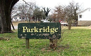
Parkridge is a neighborhood in Knoxville, Tennessee, United States, located off Magnolia Avenue east of the city's downtown area. Developed as a streetcar suburb for Knoxville's professional class in the 1890s, the neighborhood was incorporated as the separate city of Park City in 1907, and annexed by Knoxville in 1917. In the early 1900s, the neighborhood provided housing for workers at the nearby Standard Knitting Mill factory.

The Nakoma Historic District is a historic neighborhood on the southwest side of Madison, Wisconsin near the Nakoma Country Club, including contributing houses built from 1915 to 1946. In 1998 the large district was added to the National Register of Historic Places, primarily for having "the finest collection of Period Revival style buildings" in Madison.

The Chestnut Hill Historic District encompasses the historic portion of the village of Chestnut Hill that lies in Brookline, Massachusetts, with only slight overlap into adjacent Newton. The 70-acre (28 ha) district is bounded on the north by Middlesex Road, on the east by Reservoir Lane, on the south by Crafts Road and Massachusetts Route 9, and on the west by Dunster Road. A small portion of the district extends south of Route 9, including a few houses and the Baldwin School on Heath Street. The district was listed on the National Register of Historic Places on October 17, 1985.
The Highland Historic District is a nationally recognized historic district located in Waterloo, Iowa, United States. It was listed on the National Register of Historic Places in 1984. Because of industrial growth the city's population doubled between 1890 and 1900, and then again between 1900 and 1910. The housing development named the Highlands was developed during this period of economic growth. John Steely, a real estate broker, and Lewis Lichty, an attorney who owned the Waterloo Canning Company, bought the property known as sandhill in 1901, and opened an office for the Highland Land Company in the Century Building in 1905. The historic district is all residential buildings. The oldest house predates the development having been built in 1900. Otherwise construction began in the center of the district in 1908 and moved outward. By 1942 all but 15 houses were built. They are all frame construction with exteriors composed of wood, stucco, brick and stone. Styles popular in the district include Colonial Revival, Tudor Revival and American Craftsman. Waterloo architect Mortimer B. Cleveland is responsible for designing at least 39 of the houses here. Chicago landscape architect Howard Evarts Weed designed the Square and boulevard plantings. This was Waterloo's first suburban residential development. It became the enclave for the city's industrial and professional elite in the first half of the 20th century.


