Related Research Articles

Liberia, officially the Republic of Liberia, is a country on the West African coast. It is bordered by Sierra Leone to its northwest, Guinea to its north, Ivory Coast to its east, and the Atlantic Ocean to its south and southwest. It has a population of around 5 million and covers an area of 43,000 square miles (111,369 km2). English is the official language, but over 20 indigenous languages are spoken, reflecting the country's ethnic and cultural diversity. The country's capital and largest city is Monrovia.

Montserrado County is a county in the northwestern portion of the West African nation of Liberia containing its national capital, Monrovia. One of 15 counties that comprise the first-level of administrative division in the nation, it has 17 sub political districts. As of the 2008 Census, it had a population of 1,118,241, making it the most populous county in Liberia. The area of the county measures 1,912.7 square kilometres (738.5 sq mi), the smallest in the country. Bensonville serves as the capital.

Maryland County is a county in the southeastern portion of Liberia. One of 15 counties that comprise the first-level of administrative division in the nation, it has two districts. Harper serves as the capital with the area of the county measuring 2,297 square kilometres (887 sq mi). As of the 2008 Census, it had a population of 136,404, making it the seventh most populous county in Liberia.
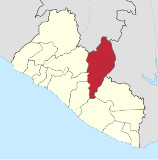
Nimba County is a county in northeastern Liberia that shares borders with the Republic of Côte d'Ivoire in the East and the Republic of Guinea in the Northwest. Its capital city is Sanniquellie and its most populous city is Ganta. With the county's area measuring 11,551 square kilometres (4,460 sq mi), Nimba is the largest of Liberia's 15 counties. The county has six statutory districts. As of the 2008 Census, it had a population of 462,026, making it the second most-populous county in Liberia.

Gbarpolu is a county in the northern portion of Liberia. One of 15 counties that comprise the first-level of administrative division in the nation, it has six districts. Bopulu serves as the capital with the area of the county measuring 9,689 square kilometres (3,741 sq mi). As of the 2008 Census, it had a population of 83,758, making it the eleventh-most populous county in Liberia.

Bomi is a county in the northwestern portion of the West African nation of Liberia. The county was established in 1984. The county's area is 746 square miles (1,900 km2).

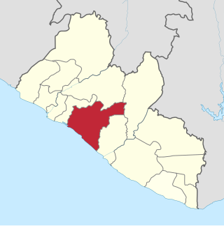
Bong is a county in the north-central portion of the West African nation of Liberia. One of 15 counties that comprise the first-level of administrative division in the nation, it has twelve districts. Gbarnga serves as the capital. The area of the county measures 8,772 square kilometres (3,387 sq mi). As of the 2008 Census, it had a population of 328,919, making it the third-most populous county in Liberia. The county was organized in 1964 and is important for its mining industry.
Grand Bassa is a county in the west-central portion of the West African nation of Liberia. One of 15 counties that comprise the first-level of administrative division in the nation, it has eight districts. Buchanan serves as the capital with the area of the county measuring 7,936 square kilometres (3,064 sq mi). As of the 2008 Census, it had a population of 224,839, making it the fifth most populous county in Liberia.

Grand Kru County is a county in the southeastern portion of Liberia. One of 15 counties that comprise the first-level of administrative division in the nation, it has eighteen districts. Organized in 1984, its capital is Barclayville. The area of the county measures 3,895 square kilometres (1,504 sq mi). As of the 2008 Census, it had a population of 57,106, making it the least populous county in Liberia.

River Gee is a county in the southern portion of Liberia. One of 15 counties that constitute the first-level of administrative division in the nation, it has six districts. Fish Town serves as the capital with the area of the county measuring 5,113 square kilometres (1,974 sq mi). As of the 2008 Census, it had a population of 66,789, making it the third-least populous county in Liberia. It was created in 2000.

Klay District is one of four administrative districts of Bomi County, Liberia. As of 2008 the population was 22,355.
Seuhn Mecca District is one of four administrative districts of Bomi County, Liberia.
Careysburg District is one of four districts located in Montserrado County, Liberia. Bensonville is the capital, and the total district population is 28,463.
Greater Monrovia is one of four districts located in Montserrado County, Liberia. It contains the country's capital Monrovia. It recorded a population of 970,824 in the 2008 census.
St. Paul River is a district located in Montserrado County, Liberia. It recorded a population of 71,831 in the 2008 census. It has no official administrative status. Its inhabitants are primarily Christians and members of the Bassa, Dey, or Kpelle tribes. Farming and fishing are the main economic activities along with some small scale trading. The district has one paved road.
Gbeapo District is one of 10 districts of River Gee County, Liberia. As of 2008, the population was 10,934.
Dewoin District is one of four administrative districts of Bomi County, Liberia. As of 2008 the population was 12,782.
Sanquin District 2 is one of 16 districts of Sinoe County, Liberia. As of 2008, the population was 3,405.
Nyenawliken District (Nyanawriliken) is one of 10 districts of River Gee County, Liberia. As of 2008, the population was 5,159.

Rivercess County is a county in the south-central portion of the West African nation of Liberia. One of 15 counties that compose the first-level of administrative division in the nation, it has six districts. Cesstos City serves as the capital with the area of the county measuring 5,594 square kilometres (2,160 sq mi). As of the 2008 Census, it had a population of 71,509, making it the second least populous county in Liberia after Grand Kru County.
References
- ↑ "River Cess County Development Agenda" (PDF). Republic of Liberia. 2008. Retrieved 2008-10-20.
- ↑ "2008 National Population and Housing Census" (PDF). Government of the Republic of Liberia. 2008. Retrieved 2010-03-10.
| | This Liberia location article is a stub. You can help Wikipedia by expanding it. |