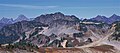
Mount Larrabee is a 7,865-foot (2,397-metre) Skagit Range mountain summit situated 1.4 mile south of the Canada–United States border, in the North Cascades of Washington state. It is located immediately southeast of American Border Peak within the Mount Baker Wilderness, which is part of the Mount Baker-Snoqualmie National Forest, and near North Cascades National Park. It is notable for its reddish coloring caused by oxidation of Iron in the rock. The rock consists of reddish interbedded and interfolded phyllites and greenstone. Originally known as Red Mountain, the name was changed in 1951 to honor Charles F. Larrabee (1895–1950), of the prominent Larrabee family of Bellingham, Washington. The toponym was officially adopted in 1951 by the U.S. Board on Geographic Names.

Tomyhoi Peak is a 7,439-foot (2,267-metre) Skagit Range mountain situated one mile south of the Canada–United States border, in the North Cascades of Washington state. It is located west of Mount Larrabee and within the Mount Baker Wilderness, which is part of the Mount Baker-Snoqualmie National Forest. This mountain's toponym was officially adopted in 1913 by the U.S. Board on Geographic Names.

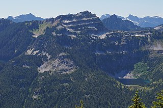
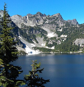
Ruth Mountain is a 7,115 ft (2,170 m) Skagit Range summit located two miles south of Hannegan Pass in the North Cascades of Washington state. The name honors Ruth Cleveland, daughter of President Grover Cleveland. This mountain's name was officially adopted in 1952 by the United States Board on Geographic Names. Ruth Mountain is situated on the shared border of North Cascades National Park and the Mount Baker Wilderness, which is part of the Mount Baker-Snoqualmie National Forest. The summit offers views of Mount Shuksan, East Nooksack Glacier, Seahpo Peak, Nooksack Tower, Icy Peak, Mount Sefrit, Mineral Mountain, and the Picket Range. The melting and receding Ruth Glacier on the north slope of Ruth creates the headwaters for the Chilliwack River. Precipitation runoff also finds its way into the Nooksack and Baker Rivers.

Mount Sefrit is a 7,191 ft (2,190 m) Skagit Range summit located three miles north of Mount Shuksan in the North Cascades of Washington state. It is situated in the Mount Baker Wilderness, which is managed by the Mount Baker-Snoqualmie National Forest. The summit offers views of Mount Shuksan, Mount Baker, and the Picket Range. Mount Sefrit's name honors Frank Ira Sefrit (1867–1950), editor and publisher of The Bellingham Herald for nearly 40 years. This mountain's name was officially adopted in 1952 by the U.S. Board on Geographic Names. Precipitation runoff from the mountain drains into the deep valleys of Ruth Creek and the Nooksack River which nearly encircle Mount Sefrit, except for Nooksack Ridge which connects it to Ruth Mountain.

Table Mountain is a Skagit Range summit located west of Mount Shuksan and northeast of Mount Baker in the North Cascades of Washington state. It is situated in the Mount Baker Wilderness, which is managed by the Mount Baker-Snoqualmie National Forest. Table Mountain is located west of Artist Point, at the end of the Mount Baker Highway. From the Artist Point parking lot, a short 1.4 mile trail leads to the summit at the west end of the mountain. The summit offers views of Mount Shuksan, Mount Baker, Mount Hermann, and Mount Larrabee. Remnants of the Table Mountain Glacier are on the northeast slope. Precipitation runoff from the mountain drains into tributaries of the Skagit and Nooksack Rivers.

Goat Mountain is a 6,844-foot (2,086-metre) summit in the Skagit Range which is a subset of the North Cascades of Washington state. It is located south of Mount Larrabee and north of Mount Shuksan in the Mount Baker Wilderness, which is managed by the Mount Baker-Snoqualmie National Forest. Goat Mountain has a subsidiary 6,725 ft summit known as the west peak, and remnants of what was colloquially known as the Swamp Creek Glacier rest on the northern slope between the two summits. The nearest higher neighbor is Mount Chardonnay, 2.75 mi (4.43 km) to the east. The Silver Tip Mine was located on the south slope of the mountain near the 3,000 ft level. The mine produced silver and gold in the 1940s. Precipitation runoff from the mountain drains into tributaries of the Fraser River and the Nooksack River.

Mount Chaval is a craggy 7,127-foot (2,172-metre) mountain summit located in Skagit County of Washington state. Situated within the Glacier Peak Wilderness, Mount Chaval is positioned west of the crest of the North Cascades Range, approximately 15 miles northeast of the town of Darrington. It has two subsidiary peaks, East Peak and Middle Peak, each 7040 ft. The nearest higher neighbor is Snowking Mountain, 2.51 miles (4.04 km) to the northeast. Precipitation runoff from Mount Chaval drains into tributaries of the Skagit River.

Snowking Mountain is a 7,433-foot (2,266-metre) summit located in Skagit County of Washington state. Situated within the Glacier Peak Wilderness, Snowking Mountain is positioned west of the crest of the North Cascades, approximately 18 miles northeast of the town of Darrington. It is set within the Glacier Peak Wilderness, on land managed by Mount Baker–Snoqualmie National Forest. Snowking has two subsidiary peaks, West Peak (7,425 ft), and Middle Peak (7,400 ft). A broad unnamed glacier known colloquially as Snowking Glacier rests on the north face. Downslope of that glacier are Snowking Lake, Found Lake, and Cyclone Lake. Mount Tommy Thompson is three miles to the northwest, and the nearest higher neighbor is Mount Misch, 5.75 miles (9.25 km) to the southeast. Precipitation runoff from Snowking Mountain drains into tributaries of the Skagit River.
Terrace Mountain is a 6,361-foot (1,939-metre) mountain summit located in the Alpine Lakes Wilderness in eastern King County of Washington state. It is part of the Cascade Range and is situated on land managed by Mount Baker-Snoqualmie National Forest. The peak is situated 4 mi (6.4 km) north of Mount Daniel, and is surrounded by Lake Clarice, Marmot Lake, Ptarmigan Lakes, and the Terrace Lakes. Precipitation runoff from the mountain drains into tributaries of the Skykomish River. Topographic relief is significant as the summit rises over 1,800 feet above Lake Clarice in less than one-half mile (0.8 km). The mountain's descriptive name stems from the terrace-like appearance created by a series of benches on its east aspect.

Granite Mountain is a 6,692-foot (2,040-metre) mountain summit located in the Skagit Range, which is a subset of the North Cascades in Whatcom County of Washington state. It is situated 1.7 mi (2.7 km) south of Mount Chardonnay, and 1.2 mi (1.9 km) northwest of Hannegan Peak in the Mount Baker Wilderness, which is managed by the Mount Baker-Snoqualmie National Forest. Precipitation runoff from the mountain drains into tributaries of the Fraser River and the Nooksack River.

Mount Chardonnay is a prominent 7,020+ ft mountain summit located in the Skagit Range, which is a subset of the North Cascades in Whatcom County of Washington state. It is situated 1.7 mi (2.7 km) north of Granite Mountain and 2.75 mi (4.43 km) east of Goat Mountain in the Mount Baker Wilderness, which is managed by the Mount Baker-Snoqualmie National Forest. The nearest higher peak is Mount Sefrit, 2.77 mi (4.46 km) to the southwest. Precipitation runoff from the mountain drains into Silesia Creek, a tributary of the Fraser River.

Hannegan Peak is a 6,191-foot elevation (1,887 m) mountain summit located in the Skagit Range, which is a subset of the North Cascades in Whatcom County of Washington state. It is situated immediately north of Hannegan Pass, and 2.2 mi (3.5 km) north of Ruth Mountain in the Mount Baker Wilderness, which is managed by Mount Baker-Snoqualmie National Forest. Banning Austin and R.M. Lyle made the first ascent of Hannegan Peak in 1893 while surveying for a possible road across the Cascades over Hannegan Pass to Whatcom Pass. This peak was named in association with Hannegan Pass, which in turn was named for Tom Hannegan, State Road Commissioner at that time. Although no road was built, a four-mile trail leads hikers to the pass, and another one-mile path leads to the summit. Peaks which can be seen from the summit include Mount Shuksan, Ruth Mountain, Mineral Mountain, Mount Baker, Mount Sefrit, Mount Larrabee, Granite Mountain, Mount Chardonnay, Mount Rexford, the Picket Range, and many more.
Mount Roosevelt is a 5,835-foot (1,779-metre) mountain summit located six miles (9.7 km) northwest of Snoqualmie Pass, in east King County of Washington state. It's part of the Cascade Range and is situated within the Alpine Lakes Wilderness, on land managed by Mount Baker-Snoqualmie National Forest. Mount Roosevelt is set above the western shore of Snow Lake, and two miles (3.2 km) immediately north of Kaleetan Peak, which is the nearest higher neighbor. Precipitation runoff from the mountain drains into tributaries of the Snoqualmie River. This mountain's toponym was officially adopted in 1989 by the U.S. Board on Geographic Names.

Malachite Peak is a 6,261-foot (1,908-metre) mountain summit located 5.5 mi (8.9 km) south of Skykomish, in eastern King County of Washington state. It's part of the Cascade Range, and is situated one mile north of Lake Malachite in the Alpine Lakes Wilderness, on land managed by Mount Baker-Snoqualmie National Forest. Precipitation runoff from the mountain drains into tributaries of the Skykomish River. The nearest higher neighbor is Camp Robber Peak, 3.66 mi (5.89 km) to the south. The first ascent of this peak may have been in 1937 by a team from the United States Geological Survey. The USGS named the peak about 1975 based on a triangulation station marked as "Malachite".

Pocket Peak is a 7,056-foot (2,151-metre) mountain summit located in the Skagit Range, which is a subset of the North Cascades in Whatcom County of Washington state. It is situated immediately west of Pocket Lake, and 4 mi (6.4 km) east of Mount Larrabee in the Mount Baker Wilderness, which is managed by Mount Baker-Snoqualmie National Forest. Pocket Peak is set on the Slesse Divide, 0.7 mile south of the Canada–United States border. Its nearest higher neighbor is Rapid Peak, 2.24 mi (3.60 km) to the southeast, North Big Bosom Butte is 2.5 miles to the southwest, and Slesse Mountain is set 3.24 mi (5.21 km) to the northwest. Other peaks which can be seen from the summit include Mount Baker, Mount Shuksan, American Border Peak, Mount Chardonnay, Mount Rexford, and many more. This unofficially named peak is named in association with officially named Pocket Lake. Precipitation runoff from this mountain drains into Silesia and Ensawkwatch Creeks, which are both tributaries of the Chilliwack River.

Bald Eagle Peak is a 6,259-foot (1,908-metre) mountain summit located 7.4 mi (11.9 km) southeast of Skykomish, in eastern King County of Washington state. It's part of the Cascade Range, and is situated in the Alpine Lakes Wilderness, on land managed by Mount Baker-Snoqualmie National Forest. Precipitation runoff from this mountain drains into tributaries of the Foss River. This peak is set on the divide between the east and west forks of Foss River. The nearest neighbor is Silver Eagle Peak, 1.1 mi (1.8 km) to the southwest, and Bald Eagle Lake lies in a cirque midway between the pair. The first ascent of this peak was made in 1933 by Hermann Ulrichs and Ben Falkenburg via the North Ridge. This mountain's toponym and correct location was officially adopted September 8, 1988, by the U.S. Board on Geographic Names. Some older maps will have this peak erroneously labeled at Silver Eagle Peak's location.
Silver Eagle Peak is a 6,241-foot (1,902-metre) mountain summit located 7.7 mi (12.4 km) southeast of Skykomish, in eastern King County of Washington state. It is part of the Cascade Range, and is situated in the Alpine Lakes Wilderness, on land managed by Mount Baker-Snoqualmie National Forest. Precipitation runoff from this mountain drains into tributaries of the Foss River. This peak is set on the divide between the east and west forks of Foss River. Malachite Peak is set 2.6 mi (4.2 km) to the west-northwest, and the nearest higher neighbor is Bald Eagle Peak, 1.1 mi (1.8 km) to the northeast. Bald Eagle Lake lies in a cirque midway between Silver Eagle and Bald Eagle. The first ascent of this peak was made in 1934 by Hermann Ulrichs and three companions. This mountain's toponym was officially adopted September 8, 1988, by the U.S. Board on Geographic Names. Some older maps will have this peak erroneously labeled as Bald Eagle Peak.

North Big Bosom Butte is a 6,384-foot (1,946-metre) mountain summit located in Whatcom County of Washington state.
Mount Watson is a 6,220-foot-elevation (1,900-meter) summit located in the North Cascades, in Whatcom County of Washington state.
Mount Ann is a 5,840-foot-elevation (1,780-meter) mountain summit located in the North Cascades in Whatcom County of Washington state. It is set within the Mount Baker Wilderness, on land managed by Mount Baker-Snoqualmie National Forest, and is only one mile outside the boundary of North Cascades National Park. Mount Ann is situated immediately southwest of line parent Mount Shuksan and northeast of Mount Baker. Mount Ann can be seen south of Artist Point which is at the end of the Mount Baker Highway. Precipitation runoff from the mountain drains into Swift Creek and Shuksan Creek, which empty into Baker Lake. Topographic relief is significant as the west aspect rises 3,200 feet above Swift Creek in approximately one mile. The mountain is unofficially named in association with nearby Lake Ann. Due to its proximity to the Mt. Baker Ski Area, Mount Ann is a winter destination for skiing and snowshoeing.